![](/images/other/stat-length.png)
![Trail Walking Banyuls-sur-Mer - Banyuls Cerbère - Littoral retour bus - 10km 4h 320m déniv. - Photo](https://media.geolcdn.com/t/1900/400/ext.pjpeg?maxdim=2&url=https%3A%2F%2Fstatic1.geolcdn.com%2Fsiteimages%2Fupload%2Ffiles%2F1553511878bg_sport_marche.png)
Banyuls Cerbère - Littoral retour bus - 10km 4h 320m déniv.
jopost
User
![Length](/images/other/stat-length.png)
![Max alt](https://static1.geolcdn.com/siteimages/upload/files/1508320355ic_sort_altitude_max_24dp.png)
![Uphill gradient](https://static1.geolcdn.com/siteimages/upload/files/1508320355ic_sort_den_pos_24dp.png)
![Km-Effort](/images/other/stat-length.png)
![Min alt](https://static1.geolcdn.com/siteimages/upload/files/1508320355ic_sort_altitude_min_24dp.png)
![Downhill gradient](https://static1.geolcdn.com/siteimages/upload/files/1508320355ic_sort_den_neg_24dp.png)
![Boucle](https://static1.geolcdn.com/siteimages/upload/files/16400158638029165_repeat_loop_refresh_sync_direction_icon.png)
![Walking](https://static1.geolcdn.com/sitytour/trail-icons/101.png)
4h12
Difficulty : Difficult
![Scan this QR Code to open this trail in the SityTrail application](https://capi.geolives.com/qq0zvz2zws4bq2lad0pu/sitytour/trails/2719227/qr.png?size=200)
FREE GPS app for hiking
About
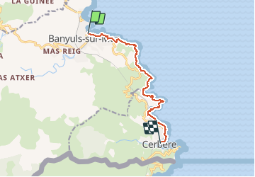
Trail Walking of 10 km to be discovered at Occitania, Pyrénées-Orientales, Banyuls-sur-Mer. This trail is proposed by jopost.
Description
Conseils: De préférence partir le matin vers 8h, cela vous permettra de rentrer avec le bus de 13h10 sinon bus à 18h10 et puis en été il fera moins chaud.
Rando effectuée le 24 mars 2021.
Départ depuis l'office de Tourisme, dirigez vous vers le port et longez l'université P. et M. Curie , au fond prendre l'escalier à droite puis longez la route jusqu'au Troc, ensuite suivez le sentier.
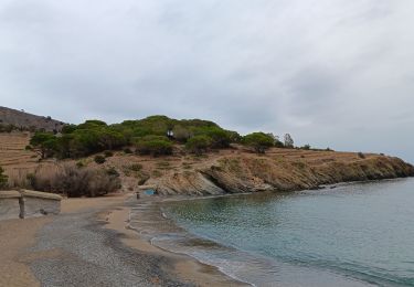
A 4km et 1h30, vous revenez sur la route et sur votre gauche vous trouverez une table d'interprétation, petite pause et direction le Cap de Rederis puis vers 5,7km la plage de Peyrefite. A 6,8km vous serez au Cap de Peyrefite, superbe vue, reprenez la rando vers le Cap Canadell et suivez la voie ferrée puis retrouvez la route vers 9,3km et arrivée devant l'office de Tourisme, arrêt de bus à côté. Pause sur la plage avant de repartir en bus.
Positioning
Comments
Trails nearby
![Trail Walking Port-Vendres - Le sentier des douaniers (Port-Vendres) - Photo](https://media.geolcdn.com/t/375/260/ext.jpg?maxdim=2&url=https%3A%2F%2Fservices.sitytrail.com%2FGeolivesWS%2FDownloadMedia.ashx%3FTrailID%3D109697%26Media%3D4388_1.jpg)
![Walking Walking](https://static1.geolcdn.com/sitytour/trail-icons/101.png)
Walking
![](/images/other/stat-length.png)
![](https://static1.geolcdn.com/siteimages/upload/files/16400158638029165_repeat_loop_refresh_sync_direction_icon.png)
![Trail Walking Port-Vendres - PORT-VENDRES 66 - Sentier littoral jusqu'à BANYULS-SUR-MER - retour par l'arrière pays et le vignoble - Photo](https://media.geolcdn.com/t/375/260/ext.jpg?maxdim=2&url=https%3A%2F%2Fservices.sitytrail.com%2FGeolivesWS%2FDownloadMedia.ashx%3FTrailID%3D427381%26Media%3D20150529181934.jpg)
![Walking Walking](https://static1.geolcdn.com/sitytour/trail-icons/101.png)
Walking
![](/images/other/stat-length.png)
![](https://static1.geolcdn.com/siteimages/upload/files/16400158638029165_repeat_loop_refresh_sync_direction_icon.png)
![Trail Walking Banyuls-sur-Mer - BANYULS- SUR-MER 66 - Sentier littoral - cap Rederis - col de la Creu - Photo](https://media.geolcdn.com/t/375/260/ext.jpg?maxdim=2&url=https%3A%2F%2Fservices.sitytrail.com%2FGeolivesWS%2FDownloadMedia.ashx%3FTrailID%3D420771%26Media%3D20150514182111.jpg)
![Walking Walking](https://static1.geolcdn.com/sitytour/trail-icons/101.png)
Walking
![](/images/other/stat-length.png)
![](https://static1.geolcdn.com/siteimages/upload/files/16400158638029165_repeat_loop_refresh_sync_direction_icon.png)
![Trail Walking Banyuls-sur-Mer - Littoral Banyuls-Cerbere - Photo](https://media.geolcdn.com/t/375/260/ext.jpg?maxdim=2&url=https%3A%2F%2Fservices.sitytrail.com%2FGeolivesWS%2FDownloadMedia.ashx%3FTrailID%3D189223%26Media%3D20130505142649.jpg)
![Walking Walking](https://static1.geolcdn.com/sitytour/trail-icons/101.png)
Walking
![](/images/other/stat-length.png)
![](https://static1.geolcdn.com/siteimages/upload/files/16400158638029165_repeat_loop_refresh_sync_direction_icon.png)
![Trail Walking Port-Vendres - port vendres - Photo](https://media.geolcdn.com/t/375/260/ext.jpg?maxdim=2&url=https%3A%2F%2Fservices.sitytrail.com%2FGeolivesWS%2FDownloadMedia.ashx%3FTrailID%3D158417%26Media%3D20121016172940.jpg)
![Walking Walking](https://static1.geolcdn.com/sitytour/trail-icons/101.png)
Walking
![](/images/other/stat-length.png)
![](https://static1.geolcdn.com/siteimages/upload/files/16400158638029165_repeat_loop_refresh_sync_direction_icon.png)
![Trail Walking Port-Vendres - anse des paulilles - cap bear / retour par les vignes - Photo](https://media.geolcdn.com/t/375/260/25d83323-aada-4695-b055-cec53d82e905.jpg&format=jpg&maxdim=2)
![Walking Walking](https://static1.geolcdn.com/sitytour/trail-icons/101.png)
Walking
![](/images/other/stat-length.png)
![](https://static1.geolcdn.com/siteimages/upload/files/16400158638029165_repeat_loop_refresh_sync_direction_icon.png)
![Trail Walking Port-Vendres - les batteries . collioure . fort sant elme . port vendres . cap gros - Photo](https://media.geolcdn.com/t/375/260/31b91983-60a6-456d-b3fc-f10bbbc18d2f.jpg&format=jpg&maxdim=2)
![Walking Walking](https://static1.geolcdn.com/sitytour/trail-icons/101.png)
Walking
![](/images/other/stat-length.png)
![](https://static1.geolcdn.com/siteimages/upload/files/16400158638029165_repeat_loop_refresh_sync_direction_icon.png)
![Trail Walking Collioure - autour de Collioure a travers les vignes - Photo](https://media.geolcdn.com/t/375/260/72e98b5d-73ad-4de1-8a38-dca1d5f1aa6f.jpg&format=jpg&maxdim=2)
![Walking Walking](https://static1.geolcdn.com/sitytour/trail-icons/101.png)
Walking
![](/images/other/stat-length.png)
![](https://static1.geolcdn.com/siteimages/upload/files/16400158638029165_repeat_loop_refresh_sync_direction_icon.png)
![Trail Walking Banyuls-sur-Mer - puig de sallfort depuis coll de vallauria - Photo](https://media.geolcdn.com/t/375/260/32dcfbc4-3ae5-459d-8552-7ec63e3079a7.jpg&format=jpg&maxdim=2)
![Walking Walking](https://static1.geolcdn.com/sitytour/trail-icons/101.png)
Walking
![](/images/other/stat-length.png)
![](https://static1.geolcdn.com/siteimages/upload/files/16400158638029165_repeat_loop_refresh_sync_direction_icon.png)
Belle randonnée, pio't splendide. Rude au départ est calliouteuse, prévoir bonne chaussure de rando.