![](/images/other/stat-length.png)
![Trail Horseback riding Saint-Just-sur-Dive - Equirando J6 - Saint-Just-sur-Dive > Chênehutte - Photo](https://media.geolcdn.com/t/1900/400/ext.pjpeg?maxdim=2&url=https%3A%2F%2Fstatic1.geolcdn.com%2Fsiteimages%2Fupload%2Ffiles%2F1524743154cheval.jpg)
Equirando J6 - Saint-Just-sur-Dive > Chênehutte
AnaisLambert
User
![Length](/images/other/stat-length.png)
![Max alt](https://static1.geolcdn.com/siteimages/upload/files/1508320355ic_sort_altitude_max_24dp.png)
![Uphill gradient](https://static1.geolcdn.com/siteimages/upload/files/1508320355ic_sort_den_pos_24dp.png)
![Km-Effort](/images/other/stat-length.png)
![Min alt](https://static1.geolcdn.com/siteimages/upload/files/1508320355ic_sort_altitude_min_24dp.png)
![Downhill gradient](https://static1.geolcdn.com/siteimages/upload/files/1508320355ic_sort_den_neg_24dp.png)
![Boucle](https://static1.geolcdn.com/siteimages/upload/files/16400158638029165_repeat_loop_refresh_sync_direction_icon.png)
![Horseback riding](https://static1.geolcdn.com/sitytour/trail-icons/301.png)
3h51
Difficulty : Medium
![Coupling](https://static1.geolcdn.com/sitytour/trail-icons/302.png)
--
Difficulty : Medium
![Scan this QR Code to open this trail in the SityTrail application](https://capi.geolives.com/qq0zvz2zws4bq2lad0pu/sitytour/trails/2716457/qr.png?size=200)
FREE GPS app for hiking
About
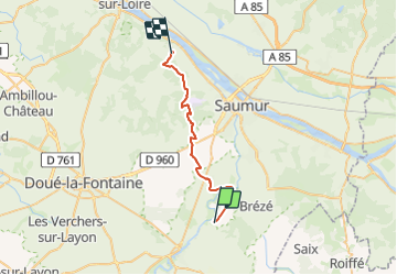
Trail Horseback riding of 26 km to be discovered at Pays de la Loire, Maine-et-Loire, Saint-Just-sur-Dive. This trail is proposed by AnaisLambert.
Description
Balade effectuée en Aout-2021 avec un attelage de 125 cm de large.
Attention,
- vers le 5ème kilomètre, à la Motte, présence de borne à l'entrée et sortie du chemin, où nous avons pu passer entre.
- au nord-ouest du Cadre Noir de Saumur, sur le GR3, un chemin en pointillé un peu étroit mais qui passe et barrière au point 77 où nous avons pu passer sur le coté.
Pour le reste, pas de difficulté particulière.
Positioning
Comments
Trails nearby
![Trail On foot Bellevigne-les-Châteaux - À la confluence du Thouet et de la Dive - Photo](https://media.geolcdn.com/t/375/260/20b36c1d-1d41-40ea-bdce-136b5a57c77b.jpeg&format=jpg&maxdim=2)
![On foot On foot](https://static1.geolcdn.com/sitytour/trail-icons/100.png)
On foot
![](/images/other/stat-length.png)
![](https://static1.geolcdn.com/siteimages/upload/files/16400158638029165_repeat_loop_refresh_sync_direction_icon.png)
![Trail Walking Bellevigne-les-Châteaux - BREZE: LE MARAIS - Photo](https://media.geolcdn.com/t/375/260/30b90cc0-ecf1-4c2c-94d4-50d35ece45a0.jpg&format=jpg&maxdim=2)
![Walking Walking](https://static1.geolcdn.com/sitytour/trail-icons/101.png)
Walking
![](/images/other/stat-length.png)
![](https://static1.geolcdn.com/siteimages/upload/files/16400158638029165_repeat_loop_refresh_sync_direction_icon.png)
![Trail Walking Bellevigne-les-Châteaux - BELLEVIGNE LES CHÂTEAUX / BRÉZÉ: LA DIVE - Photo](https://media.geolcdn.com/t/375/260/142819c3-f42b-4a39-b0c8-288fef65e8ed.jpg&format=jpg&maxdim=2)
![Walking Walking](https://static1.geolcdn.com/sitytour/trail-icons/101.png)
Walking
![](/images/other/stat-length.png)
![](https://static1.geolcdn.com/siteimages/upload/files/16400158638029165_repeat_loop_refresh_sync_direction_icon.png)
![Trail Walking Montreuil-Bellay - Montreuil-Bellay - Photo](https://media.geolcdn.com/t/375/260/38116dd8-5832-47e1-b1df-a088d60aa6ce.jpg&format=jpg&maxdim=2)
![Walking Walking](https://static1.geolcdn.com/sitytour/trail-icons/101.png)
Walking
![](/images/other/stat-length.png)
![](https://static1.geolcdn.com/siteimages/upload/files/16400158638029165_repeat_loop_refresh_sync_direction_icon.png)
![Trail Walking Montreuil-Bellay - Montreuil-Bellay - Photo](https://media.geolcdn.com/t/375/260/f8165781-32be-46d7-bc27-ad276da38098.jpg&format=jpg&maxdim=2)
![Walking Walking](https://static1.geolcdn.com/sitytour/trail-icons/101.png)
Walking
![](/images/other/stat-length.png)
![](https://static1.geolcdn.com/siteimages/upload/files/16400158638029165_repeat_loop_refresh_sync_direction_icon.png)
![Trail Walking Bellevigne-les-Châteaux - BREZE: LA BOUCHARDIERE - Photo](https://media.geolcdn.com/t/375/260/2c925077-c9ca-4c18-90b3-0d0709f34746.jpg&format=jpg&maxdim=2)
![Walking Walking](https://static1.geolcdn.com/sitytour/trail-icons/101.png)
Walking
![](/images/other/stat-length.png)
![](https://static1.geolcdn.com/siteimages/upload/files/16400158638029165_repeat_loop_refresh_sync_direction_icon.png)
![Trail Walking Épieds - EPIEDS: Entre maraîchage, labourage et canotage - Photo](https://media.geolcdn.com/t/375/260/500c8c23-b1dd-4698-bea9-5fac1ebeabb5.jpg&format=jpg&maxdim=2)
![Walking Walking](https://static1.geolcdn.com/sitytour/trail-icons/101.png)
Walking
![](/images/other/stat-length.png)
![](https://static1.geolcdn.com/siteimages/upload/files/16400158638029165_repeat_loop_refresh_sync_direction_icon.png)
![Trail Walking Bellevigne-les-Châteaux - BREZE: circuit rose patrimoine - Photo](https://media.geolcdn.com/t/375/260/f0c1ab50-65f5-46d1-b557-0618528f162b.jpg&format=jpg&maxdim=2)
![Walking Walking](https://static1.geolcdn.com/sitytour/trail-icons/101.png)
Walking
![](/images/other/stat-length.png)
![](https://static1.geolcdn.com/siteimages/upload/files/16400158638029165_repeat_loop_refresh_sync_direction_icon.png)
![Trail Mountain bike Bellevigne-les-Châteaux - BELLEVIGNE LES CHÂTEAUX / BRÉZÉ: LE GRAND TOUR - Photo](https://media.geolcdn.com/t/375/260/054b1370-d22d-4ef0-8f89-221444296662.jpg&format=jpg&maxdim=2)
![Mountain bike Mountain bike](https://static1.geolcdn.com/sitytour/trail-icons/202.png)
Mountain bike
![](/images/other/stat-length.png)
![](https://static1.geolcdn.com/siteimages/upload/files/16400158638029165_repeat_loop_refresh_sync_direction_icon.png)