![](/images/other/stat-length.png)
![Trail Walking Mimet - Massif de l'Etoile - Le Col Sainte-Anne - Le Pilon du Roi - Le Col des Ouides - Photo](https://media.geolcdn.com/t/1900/400/ext.pjpeg?maxdim=2&url=https%3A%2F%2Fstatic1.geolcdn.com%2Fsiteimages%2Fupload%2Ffiles%2F1553511878bg_sport_marche.png)
Massif de l'Etoile - Le Col Sainte-Anne - Le Pilon du Roi - Le Col des Ouides
pourrier
User
![Length](/images/other/stat-length.png)
![Max alt](https://static1.geolcdn.com/siteimages/upload/files/1508320355ic_sort_altitude_max_24dp.png)
![Uphill gradient](https://static1.geolcdn.com/siteimages/upload/files/1508320355ic_sort_den_pos_24dp.png)
![Km-Effort](/images/other/stat-length.png)
![Min alt](https://static1.geolcdn.com/siteimages/upload/files/1508320355ic_sort_altitude_min_24dp.png)
![Downhill gradient](https://static1.geolcdn.com/siteimages/upload/files/1508320355ic_sort_den_neg_24dp.png)
![Boucle](https://static1.geolcdn.com/siteimages/upload/files/16400158638029165_repeat_loop_refresh_sync_direction_icon.png)
![Walking](https://static1.geolcdn.com/sitytour/trail-icons/101.png)
6h43
Difficulty : Unknown
![Scan this QR Code to open this trail in the SityTrail application](https://capi.geolives.com/qq0zvz2zws4bq2lad0pu/sitytour/trails/2715699/qr.png?size=200)
FREE GPS app for hiking
About
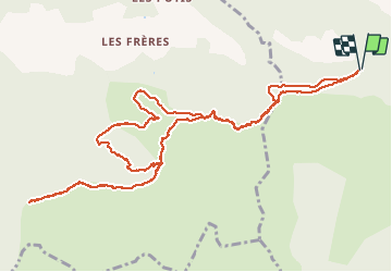
Trail Walking of 14.6 km to be discovered at Provence-Alpes-Côte d'Azur, Bouches-du-Rhône, Mimet. This trail is proposed by pourrier.
Description
Départ du parking du Col de Sainte-Anne puis contourner le Pilon du roi et poursuivre par Les Santons, La Colle et Luminier jusqu'au Col des Ouides. On peut poursuivre jusqu'aux Antennes de l'Etoile et de la Grande Etoile.
Retour par le même chemin et descendre avant la Colle le vallon puis remonter par un chemin escarpé par le Vallon d'Hayette jusqu'au chemin DFCI.
Retour au parking par la piste DFCI et la variante au départ de la citerne du Col Sainte-Anne.
Positioning
Comments
Trails nearby
![Trail Walking Allauch - SityTrail - le Pilon - Photo](https://media.geolcdn.com/t/375/260/f70c47ce-637e-4170-ac86-2a2a395feaa2.jpg&format=jpg&maxdim=2)
![Walking Walking](https://static1.geolcdn.com/sitytour/trail-icons/101.png)
Walking
![](/images/other/stat-length.png)
![](https://static1.geolcdn.com/siteimages/upload/files/16400158638029165_repeat_loop_refresh_sync_direction_icon.png)
![Trail Walking Allauch - Le tour des Grands Ubacs au départ de Pichauris - Photo](https://media.geolcdn.com/t/375/260/21675de2-6304-4cb6-a0f7-b5d15f62bb3e.jpg&format=jpg&maxdim=2)
![Walking Walking](https://static1.geolcdn.com/sitytour/trail-icons/101.png)
Walking
![](/images/other/stat-length.png)
![](https://static1.geolcdn.com/siteimages/upload/files/16400158638029165_repeat_loop_refresh_sync_direction_icon.png)
![Trail Walking Allauch - Domaine de Pichauris - Allauch - Photo](https://media.geolcdn.com/t/375/260/ext.jpg?maxdim=2&url=https%3A%2F%2Fservices.sitytrail.com%2FGeolivesWS%2FDownloadMedia.ashx%3FTrailID%3D103813%26Media%3D6587_1.jpg)
![Walking Walking](https://static1.geolcdn.com/sitytour/trail-icons/101.png)
Walking
![](/images/other/stat-length.png)
![](https://static1.geolcdn.com/siteimages/upload/files/16400158638029165_repeat_loop_refresh_sync_direction_icon.png)
![Trail Walking Allauch - le pic du Taoumé par Pichauris - Photo](https://media.geolcdn.com/t/375/260/6e9ae51a-41c8-431b-88f6-0e231e4db660.jpg&format=jpg&maxdim=2)
![Walking Walking](https://static1.geolcdn.com/sitytour/trail-icons/101.png)
Walking
![](/images/other/stat-length.png)
![](https://static1.geolcdn.com/siteimages/upload/files/16400158638029165_repeat_loop_refresh_sync_direction_icon.png)
![Trail Mountain bike Allauch - les antennes du garlaban à modifier - Photo](https://media.geolcdn.com/t/375/260/b5861fec-07e7-4c16-8ca8-179e78ebdfae.jpg&format=jpg&maxdim=2)
![Mountain bike Mountain bike](https://static1.geolcdn.com/sitytour/trail-icons/202.png)
Mountain bike
![](/images/other/stat-length.png)
![](https://static1.geolcdn.com/siteimages/upload/files/16400158638029165_repeat_loop_refresh_sync_direction_icon.png)
![Trail Mountain bike Allauch - les antennes du garlaban - Photo](https://media.geolcdn.com/t/375/260/b5861fec-07e7-4c16-8ca8-179e78ebdfae.jpg&format=jpg&maxdim=2)
![Mountain bike Mountain bike](https://static1.geolcdn.com/sitytour/trail-icons/202.png)
Mountain bike
![](/images/other/stat-length.png)
![](https://static1.geolcdn.com/siteimages/upload/files/16400158638029165_repeat_loop_refresh_sync_direction_icon.png)
![Trail Mountain bike Allauch - de Pichauris au mont du Marseillais - Photo](https://media.geolcdn.com/t/375/260/ext.jpg?maxdim=2&url=https%3A%2F%2Fservices.sitytrail.com%2FGeolivesWS%2FDownloadMedia.ashx%3FTrailID%3D855696%26Media%3Dfix__20171101163219.jpg)
![Mountain bike Mountain bike](https://static1.geolcdn.com/sitytour/trail-icons/202.png)
Mountain bike
![](/images/other/stat-length.png)
![](https://static1.geolcdn.com/siteimages/upload/files/16400158638029165_repeat_loop_refresh_sync_direction_icon.png)
![Trail Walking Gréasque - Gréasque-Puits Hély d'Oissel-La Diote-Les Charbonnières - Photo](https://media.geolcdn.com/t/375/260/ext.jpg?maxdim=2&url=https%3A%2F%2Fstatic1.geolcdn.com%2Fsiteimages%2Fupload%2Ffiles%2F1553511878bg_sport_marche.png)
![Walking Walking](https://static1.geolcdn.com/sitytour/trail-icons/101.png)
Walking
![](/images/other/stat-length.png)
![](https://static1.geolcdn.com/siteimages/upload/files/16400158638029165_repeat_loop_refresh_sync_direction_icon.png)
![Trail Walking Cadolive - cadolive - Photo](https://media.geolcdn.com/t/375/260/eb589fa2-2a8c-4ecf-b7eb-f49d91a9cccb.jpg&format=jpg&maxdim=2)
![Walking Walking](https://static1.geolcdn.com/sitytour/trail-icons/101.png)
Walking
![](/images/other/stat-length.png)
![](https://static1.geolcdn.com/siteimages/upload/files/16400158638029165_repeat_loop_refresh_sync_direction_icon.png)