Trail Mountain bike Ensuès-la-Redonne - Entre Carry, Sausset et Chateauneuf - Photo
© OpenStreetMap contributors
Length
Length
34 km
Max alt
Max alt
202 m
Uphill gradient
Uphill gradient
765 m
Km-Effort
Km-Effort  
44 km
Min alt
Min alt
17 m
Downhill gradient
Downhill gradient
765 m
Boucle
Boucle
Yes
Creation date :
2021-03-20 12:51:45.596
Updated on :
2021-03-22 13:55:08.357

(0 Reviews)

Mountain bike
Mountain bike
2h54
Difficulty : Difficult

Scan this QR Code to open this trail in the SityTrail application

FREE GPS app for hiking

Logo SityTrail SityTrail

IGN / Geographical institutes

Download SityTrail from the App Store Download SityTrail from Google Play

Logo SityTrail SityTrail World

The world is yours!

Download SityTrail from the App Store Download SityTrail from Google Play Download SityTrail on Huawei AppGallery

About

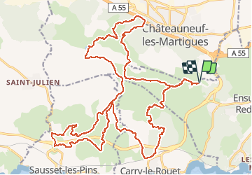
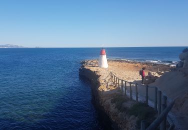
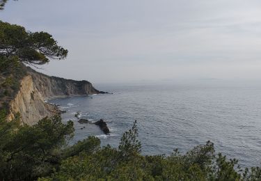
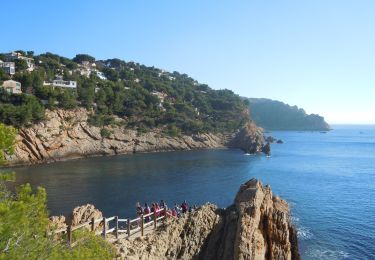
Trail Mountain bike of 34 km to be discovered at Provence-Alpes-Côte d'Azur, Bouches-du-Rhône, Ensuès-la-Redonne. This trail is proposed by samifly51.

Description

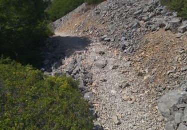
Le parking au départ de la carrière est désormais fermé. Le stationnement se fait le long de la route. Le single qui descend vers Carry devient de plus en plus compliqué à rouler et se termine à côté du vélo sur les 50 derniers mètres. Un petit porté sur 200m au Km 8.5. Pour tout le reste c'est du bonheur !

Elevation profile

Positioning

Country:
France
Region :
Provence-Alpes-Côte d'Azur
Department/Province :
Bouches-du-Rhône
Municipality :
Ensuès-la-Redonne
Location:
Unknown
Start:(UTM)
676367 ; 4803434 (31T) N.

Trails nearby

Trail On foot Carry-le-Rouet - Le Vallon de Jaume par les Grottes - Photo
On foot
GUIDE+

On foot

Easy
Carry-le-Rouet, Provence-Alpes-Côte d'Azur, Bouches-du-Rhône, France
7.5 km | 10.2 km-effort
2h 19min
No
Trail On foot Carry-le-Rouet - Le Tour du Romaron - Photo
On foot
GUIDE+

On foot

Easy
Carry-le-Rouet, Provence-Alpes-Côte d'Azur, Bouches-du-Rhône, France
7.3 km | 10 km-effort
2h 15min
No
Trail On foot Carry-le-Rouet - Entre calanques et collines - Photo
On foot
GUIDE+

On foot

Easy
Carry-le-Rouet, Provence-Alpes-Côte d'Azur, Bouches-du-Rhône, France
11.8 km | 14.6 km-effort
3h 19min
No
Trail On foot Ensuès-la-Redonne - Grand Sentier de la Côte Bleue - Photo
On foot
GUIDE+

On foot

Very difficult
Ensuès-la-Redonne, Provence-Alpes-Côte d'Azur, Bouches-du-Rhône, France
50 km | 60 km-effort
13h 34min
No
Trail Walking Ensuès-la-Redonne - 13 Méjean ebeverine redonne 02.06.24 - Photo
Walking
GUIDE
randodyssée

Walking

Medium
Ensuès-la-Redonne, Provence-Alpes-Côte d'Azur, Bouches-du-Rhône, France
10.2 km | 14.4 km-effort
3h 28min
No
Trail Walking Ensuès-la-Redonne - La Redonne - Calanques des Anthénors et de Figuières - Photo
Walking
patjobou

Walking

Medium
Ensuès-la-Redonne, Provence-Alpes-Côte d'Azur, Bouches-du-Rhône, France
4.6 km | 6.7 km-effort
1h 46min
Yes
Trail Walking Carry-le-Rouet - L'Estaque - Le Sentier du Lézard  - Photo
Walking
patjobou

Walking

Easy
Carry-le-Rouet, Provence-Alpes-Côte d'Azur, Bouches-du-Rhône, France
4.9 km | 5.7 km-effort
1h 24min
Yes
Trail Walking Ensuès-la-Redonne - laRedonne le grand Méjan - Photo
Walking
TOULAUDIN

Walking

Medium
Ensuès-la-Redonne, Provence-Alpes-Côte d'Azur, Bouches-du-Rhône, France
7.6 km | 11 km-effort
4h 5min
Yes
Trail Walking Ensuès-la-Redonne - Ensuez la redonne vers Niolon - Photo
Walking
Fayolle Chantal

Walking

Medium
Ensuès-la-Redonne, Provence-Alpes-Côte d'Azur, Bouches-du-Rhône, France
6.8 km | 10 km-effort
2h 16min
No


Close
My subscriptions