![](/images/other/stat-length.png)
![Trail Nordic walking Lay-Saint-Christophe - Lay-saint-Christophe 11 460m +225m - Photo](https://media.geolcdn.com/t/1900/400/ext.pjpeg?maxdim=2&url=https%3A%2F%2Fstatic1.geolcdn.com%2Fsiteimages%2Fupload%2Ffiles%2F1545311037marcheuse_200dpi.jpg)
Lay-saint-Christophe 11 460m +225m
DanielROLLET
User
![Length](/images/other/stat-length.png)
Length
11.5 km
![Max alt](https://static1.geolcdn.com/siteimages/upload/files/1508320355ic_sort_altitude_max_24dp.png)
Max alt
360 m
![Uphill gradient](https://static1.geolcdn.com/siteimages/upload/files/1508320355ic_sort_den_pos_24dp.png)
Uphill gradient
225 m
![Km-Effort](/images/other/stat-length.png)
Km-Effort
14.4 km
![Min alt](https://static1.geolcdn.com/siteimages/upload/files/1508320355ic_sort_altitude_min_24dp.png)
Min alt
196 m
![Downhill gradient](https://static1.geolcdn.com/siteimages/upload/files/1508320355ic_sort_den_neg_24dp.png)
Downhill gradient
222 m
![Boucle](https://static1.geolcdn.com/siteimages/upload/files/16400158638029165_repeat_loop_refresh_sync_direction_icon.png)
Boucle
Yes
Creation date :
2021-03-18 07:46:42.756
Updated on :
2021-03-18 13:11:08.614
![Nordic walking](https://static1.geolcdn.com/sitytour/trail-icons/102.png)
2h26
Difficulty : Easy
![Scan this QR Code to open this trail in the SityTrail application](https://capi.geolives.com/qq0zvz2zws4bq2lad0pu/sitytour/trails/2711350/qr.png?size=200)
FREE GPS app for hiking
About
Trail Nordic walking of 11.5 km to be discovered at Grand Est, Meurthe-et-Moselle, Lay-Saint-Christophe. This trail is proposed by DanielROLLET.
Description
2021 03 18 Marche nordique - 12 personnes - beau temps frais
08:50 à 11:10
vitesse progression réduite dans les chemins boueux
Positioning
Country:
France
Region :
Grand Est
Department/Province :
Meurthe-et-Moselle
Municipality :
Lay-Saint-Christophe
Location:
Unknown
Start:(Dec)
Start:(UTM)
294556 ; 5403017 (32U) N.
Comments
Trails nearby
![Trail On foot Champigneulles - Circuit du Val Saint-Barthélémy - Photo](https://media.geolcdn.com/t/375/260/199ee8e6-f9b7-4be8-9188-093275697409.jpeg&format=jpg&maxdim=2)
![On foot On foot](https://static1.geolcdn.com/sitytour/trail-icons/100.png)
Circuit du Val Saint-Barthélémy
On foot
Easy
Champigneulles,
Grand Est,
Meurthe-et-Moselle,
France
![](/images/other/stat-length.png)
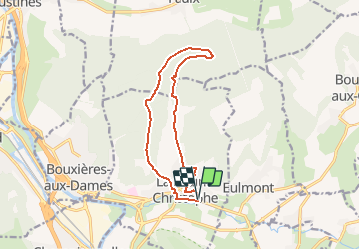
7 km | 8.6 km-effort
1h 57min
![](https://static1.geolcdn.com/siteimages/upload/files/16400158638029165_repeat_loop_refresh_sync_direction_icon.png)
Yes
![Trail On foot Agincourt - Circuit M - Photo](https://media.geolcdn.com/t/375/260/af3027bd-6d38-4135-8a9f-8cca4de624d0.jpeg&format=jpg&maxdim=2)
![On foot On foot](https://static1.geolcdn.com/sitytour/trail-icons/100.png)
Circuit M
On foot
Easy
Agincourt,
Grand Est,
Meurthe-et-Moselle,
France
![](/images/other/stat-length.png)
13.3 km | 17.8 km-effort
4h 3min
![](https://static1.geolcdn.com/siteimages/upload/files/16400158638029165_repeat_loop_refresh_sync_direction_icon.png)
No
![Trail Bicycle tourism Frouard - 4ème rando vélo Frouard - Lagarde 62 km - Photo](https://media.geolcdn.com/t/375/260/13993c5f-3965-404c-880f-e186b1a79db8.jpg&format=jpg&maxdim=2)
![Bicycle tourism Bicycle tourism](https://static1.geolcdn.com/sitytour/trail-icons/204.png)
4ème rando vélo Frouard - Lagarde 62 km
Bicycle tourism
Very difficult
Frouard,
Grand Est,
Meurthe-et-Moselle,
France
![](/images/other/stat-length.png)
62 km | 67 km-effort
4h 32min
![](https://static1.geolcdn.com/siteimages/upload/files/16400158638029165_repeat_loop_refresh_sync_direction_icon.png)
No
![Trail On foot Lay-Saint-Christophe - Circuit L - Photo](https://media.geolcdn.com/t/375/260/8edc069d-a9b9-439a-9f46-3e2f5923a387.jpeg&format=jpg&maxdim=2)
![On foot On foot](https://static1.geolcdn.com/sitytour/trail-icons/100.png)
Circuit L
On foot
Easy
Lay-Saint-Christophe,
Grand Est,
Meurthe-et-Moselle,
France
![](/images/other/stat-length.png)
14.7 km | 18.5 km-effort
4h 11min
![](https://static1.geolcdn.com/siteimages/upload/files/16400158638029165_repeat_loop_refresh_sync_direction_icon.png)
Yes
![Trail On foot Champigneulles - Circuit de Bellefontaine - général ouest - Photo](https://media.geolcdn.com/t/375/260/afefad02-ca10-49a0-94f8-a0d611ca2a91.jpeg&format=jpg&maxdim=2)
![On foot On foot](https://static1.geolcdn.com/sitytour/trail-icons/100.png)
Circuit de Bellefontaine - général ouest
On foot
Easy
Champigneulles,
Grand Est,
Meurthe-et-Moselle,
France
![](/images/other/stat-length.png)
6.1 km | 8 km-effort
1h 48min
![](https://static1.geolcdn.com/siteimages/upload/files/16400158638029165_repeat_loop_refresh_sync_direction_icon.png)
No
![Trail On foot Champigneulles - Circuit du Vallum de la Fourasse - Photo](https://media.geolcdn.com/t/375/260/ff5ef522-89ca-4a55-89a5-b4737ce72d51.jpeg&format=jpg&maxdim=2)
![On foot On foot](https://static1.geolcdn.com/sitytour/trail-icons/100.png)
Circuit du Vallum de la Fourasse
On foot
Easy
Champigneulles,
Grand Est,
Meurthe-et-Moselle,
France
![](/images/other/stat-length.png)
3.3 km | 4.9 km-effort
1h 6min
![](https://static1.geolcdn.com/siteimages/upload/files/16400158638029165_repeat_loop_refresh_sync_direction_icon.png)
Yes
![Trail On foot Bouxières-aux-Dames - Circuit moyenne ceinture - Photo](https://media.geolcdn.com/t/375/260/88bdd629-0aa3-4fce-b286-82104b98c415.jpeg&format=jpg&maxdim=2)
![On foot On foot](https://static1.geolcdn.com/sitytour/trail-icons/100.png)
Circuit moyenne ceinture
On foot
Easy
Bouxières-aux-Dames,
Grand Est,
Meurthe-et-Moselle,
France
![](/images/other/stat-length.png)
3.8 km | 5.3 km-effort
1h 12min
![](https://static1.geolcdn.com/siteimages/upload/files/16400158638029165_repeat_loop_refresh_sync_direction_icon.png)
Yes
![Trail Walking Eulmont - 2020-12-11_18h42m13_Eulmont_La tour du Crany_10kms - Photo](https://media.geolcdn.com/t/375/260/ext.jpg?maxdim=2&url=https%3A%2F%2Fstatic1.geolcdn.com%2Fsiteimages%2Fupload%2Ffiles%2F1553511878bg_sport_marche.png)
![Walking Walking](https://static1.geolcdn.com/sitytour/trail-icons/101.png)
2020-12-11_18h42m13_Eulmont_La tour du Crany_10kms
Walking
Difficult
(2)
Eulmont,
Grand Est,
Meurthe-et-Moselle,
France
![](/images/other/stat-length.png)
9.6 km | 12.6 km-effort
2h 51min
![](https://static1.geolcdn.com/siteimages/upload/files/16400158638029165_repeat_loop_refresh_sync_direction_icon.png)
Yes
![Trail Walking Dommartemont - Dommartemont - Photo](https://media.geolcdn.com/t/375/260/8cd51545-df85-4589-bd14-ed6d542f080f.jpg&format=jpg&maxdim=2)
![Walking Walking](https://static1.geolcdn.com/sitytour/trail-icons/101.png)
Dommartemont
Walking
Medium
Dommartemont,
Grand Est,
Meurthe-et-Moselle,
France
![](/images/other/stat-length.png)
29 km | 34 km-effort
3h 5min
![](https://static1.geolcdn.com/siteimages/upload/files/16400158638029165_repeat_loop_refresh_sync_direction_icon.png)
No