


6 km | 6.6 km-effort


Club randonnées SERVON


FREE GPS app for hiking
 SityTrail
IGN / Geographical institutes
SityTrail World
The world is yours!
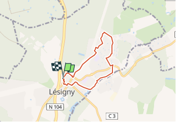
Trail On foot of 5.7 km to be discovered at Ile-de-France, Seine-et-Marne, Lésigny. This trail is proposed by Les 1000 pattes.
Itinéraire : Lésigny village
Stationnement : Rue Du Petit Parc (Carrefour market) à Lésigny
Départ : Mairie de Servon
Trajet Servon-->Lésigny (4,4km: 6mn)
Distance : 5.1 km - dénivelé 46m

On foot

Walking
On foot

On foot

Walking

On foot

On foot

Walking

Walking