Trail On foot Bilhères - La Cabane de Lasbordes - G2 - Photo

La Cabane de Lasbordes - G2

© OpenStreetMap contributors
Length
Length
11.9 km
Max alt
Max alt
1446 m
Uphill gradient
Uphill gradient
650 m
Km-Effort
Km-Effort  
21 km
Min alt
Min alt
828 m
Downhill gradient
Downhill gradient
648 m
Boucle
Boucle
Yes
Creation date :
2021-03-11 19:55:05.802
Updated on :
2022-06-08 10:34:35.431

(0 Reviews)

On foot
On foot
4h41
Difficulty : Medium

Scan this QR Code to open this trail in the SityTrail application

FREE GPS app for hiking

Logo SityTrail SityTrail

IGN / Geographical institutes

Download SityTrail from the App Store Download SityTrail from Google Play

Logo SityTrail SityTrail World

The world is yours!

Download SityTrail from the App Store Download SityTrail from Google Play Download SityTrail on Huawei AppGallery

About

Trail On foot of 11.9 km to be discovered at New Aquitaine, Pyrénées-Atlantiques, Bilhères. This trail is proposed by mitch1952.

Description

Ce circuit (D 625m) vous emmène sur les pentes du versant sud du BENOU. En prenant de la hauteur , c'est aussi  une autre dimension qui se présente à vous: un décor sauvage et des points de vue  panoramiques à près de 1500m d'altitude (Rocher d'ARAN, Massif de LAZERGUE, Montagne du REY,  Massif de JAUT,...). N'oubliez pas votre appareil photo! Après la cabane d LASBORDES, typique cujala montagnard,  la descente sur le BENOU est douce et ombragée.

Elevation profile

Positioning

Country:
France
Region :
New Aquitaine
Department/Province :
Pyrénées-Atlantiques
Municipality :
Bilhères
Location:
Unknown
Start:(UTM)
707064 ; 4770819 (30T) N.

Trails nearby

Trail Walking Louvie-Juzon - Soum de las Picarras Montagne du Rey - Photo
Walking
DuMarsan

Walking

Easy
(1)
Louvie-Juzon, New Aquitaine, Pyrénées-Atlantiques, France
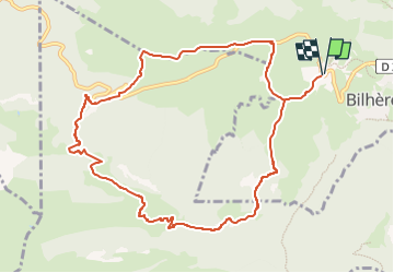
12.2 km | 25 km-effort
5h 16min
Yes
Trail Walking Bielle - Pics de Cambeilh et petit Gerbe  - Photo
Walking
DuMarsan

Walking

Easy
(1)
Bielle, New Aquitaine, Pyrénées-Atlantiques, France
13.7 km | 27 km-effort
5h 24min
Yes
Trail Walking Bielle - BIELLE l arriu Mage reco  3443541 - Photo
Walking
GUIDE
marmotte65

Walking

Difficult
Bielle, New Aquitaine, Pyrénées-Atlantiques, France
8.7 km | 14.7 km-effort
2h 47min
Yes
Trail On foot Gère-Bélesten - La fontaine d'Esteret - Photo
On foot
GUIDE+

On foot

Easy
Gère-Bélesten, New Aquitaine, Pyrénées-Atlantiques, France
3.7 km | 7.6 km-effort
1h 43min
Yes
Trail On foot Bielle - L'Arriu-Mage - Photo
On foot
GUIDE+

On foot

Easy
Bielle, New Aquitaine, Pyrénées-Atlantiques, France
8 km | 14 km-effort
3h 10min
Yes
Trail On foot Bilhères - Les cercles de pierre (Bilhères) - Photo
On foot
GUIDE+

On foot

Easy
Bilhères, New Aquitaine, Pyrénées-Atlantiques, France
7.2 km | 11.6 km-effort
2h 37min
Yes
Trail On foot Bilhères - Les cabanes de Lasbordes - Photo
On foot
GUIDE+

On foot

Easy
Bilhères, New Aquitaine, Pyrénées-Atlantiques, France
11.2 km | 19.7 km-effort
4h 28min
Yes
Trail On foot Louvie-Juzon - Le piémont du Rey - Photo
On foot
GUIDE+

On foot

Easy
Louvie-Juzon, New Aquitaine, Pyrénées-Atlantiques, France
3.5 km | 10.2 km-effort
2h 19min
No
Trail On foot Arudy - Le tour du bassin d'Arudy - Photo
On foot
GUIDE+

On foot

Medium
Arudy, New Aquitaine, Pyrénées-Atlantiques, France
19.2 km | 27 km-effort
6h 7min
Yes


Close
My subscriptions