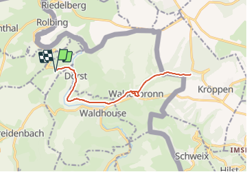
![](/images/other/stat-length.png)
![Trail Other activity Walschbronn - Ecureuils 26 avril 2014 - Photo](https://media.geolcdn.com/t/1900/400/ext.pjpeg?maxdim=2&url=https%3A%2F%2Fstatic1.geolcdn.com%2Fsiteimages%2Fupload%2Ffiles%2F1545311037marcheuse_200dpi.jpg)
Ecureuils 26 avril 2014
lucienp
User
![Length](/images/other/stat-length.png)
Length
14.4 km
![Max alt](https://static1.geolcdn.com/siteimages/upload/files/1508320355ic_sort_altitude_max_24dp.png)
Max alt
301 m
![Uphill gradient](https://static1.geolcdn.com/siteimages/upload/files/1508320355ic_sort_den_pos_24dp.png)
Uphill gradient
208 m
![Km-Effort](/images/other/stat-length.png)
Km-Effort
17.2 km
![Min alt](https://static1.geolcdn.com/siteimages/upload/files/1508320355ic_sort_altitude_min_24dp.png)
Min alt
250 m
![Downhill gradient](https://static1.geolcdn.com/siteimages/upload/files/1508320355ic_sort_den_neg_24dp.png)
Downhill gradient
209 m
![Boucle](https://static1.geolcdn.com/siteimages/upload/files/16400158638029165_repeat_loop_refresh_sync_direction_icon.png)
Boucle
Yes
Creation date :
2014-12-10 00:00:00.0
Updated on :
2014-12-10 00:00:00.0
![Other activity](https://static1.geolcdn.com/sitytour/trail-icons/900.png)
2h00
Difficulty : Easy
![Scan this QR Code to open this trail in the SityTrail application](https://capi.geolives.com/qq0zvz2zws4bq2lad0pu/sitytour/trails/270390/qr.png?size=200)
FREE GPS app for hiking
About
Trail Other activity of 14.4 km to be discovered at Grand Est, Moselle, Walschbronn. This trail is proposed by lucienp.
Description
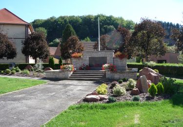
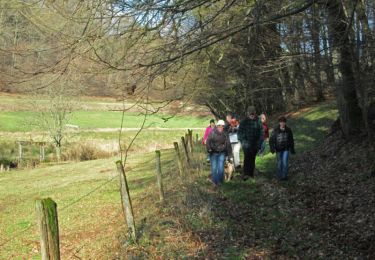
Sortie du 26 avril 2014, groupe Ecureuils de l'école cyclo de Bitche.
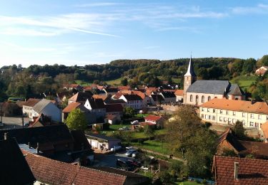
Visite de l'ancien château de Walschbronn et chasse au oeufs à Hexenfelsen
Positioning
Country:
France
Region :
Grand Est
Department/Province :
Moselle
Municipality :
Walschbronn
Location:
Unknown
Start:(Dec)
Start:(UTM)
386421 ; 5445997 (32U) N.
Comments
Trails nearby
![Trail On foot Walschbronn - Anneau bleu - Photo](https://media.geolcdn.com/t/375/260/70df8705-fd05-4999-bdfc-2508ac6b9e15.jpeg&format=jpg&maxdim=2)
![On foot On foot](https://static1.geolcdn.com/sitytour/trail-icons/100.png)
![Trail On foot Schweix - Anneau rouge - Photo](https://media.geolcdn.com/t/375/260/5ef45392-b749-445c-a602-485042878f58.jpeg&format=jpg&maxdim=2)
![On foot On foot](https://static1.geolcdn.com/sitytour/trail-icons/100.png)
Anneau rouge
On foot
Easy
Schweix,
Rhineland-Palatinate,
Südwestpfalz,
Germany
![](/images/other/stat-length.png)
11.6 km | 14.3 km-effort
3h 15min
![](https://static1.geolcdn.com/siteimages/upload/files/16400158638029165_repeat_loop_refresh_sync_direction_icon.png)
Yes
![Trail Walking Liederschiedt - Enregistré le 25 nov. 2022 13:58:31 - Photo](https://media.geolcdn.com/t/375/260/af420eb2-af54-4d1d-a556-ec096faf6265.jpg&format=jpg&maxdim=2)
![Walking Walking](https://static1.geolcdn.com/sitytour/trail-icons/101.png)
Enregistré le 25 nov. 2022 13:58:31
Walking
Medium
Liederschiedt,
Grand Est,
Moselle,
France
![](/images/other/stat-length.png)
6.1 km | 8.6 km-effort
1h 57min
![](https://static1.geolcdn.com/siteimages/upload/files/16400158638029165_repeat_loop_refresh_sync_direction_icon.png)
Yes
![Trail Walking Bousseviller - De Bousseviller à Eberbach - Photo](https://media.geolcdn.com/t/375/260/ext.jpg?maxdim=2&url=https%3A%2F%2Fservices.sitytrail.com%2FGeolivesWS%2FDownloadMedia.ashx%3FTrailID%3D317560%26Media%3D16816_6.jpg)
![Walking Walking](https://static1.geolcdn.com/sitytour/trail-icons/101.png)
De Bousseviller à Eberbach
Walking
Medium
Bousseviller,
Grand Est,
Moselle,
France
![](/images/other/stat-length.png)
13.1 km | 17.7 km-effort
3h 19min
![](https://static1.geolcdn.com/siteimages/upload/files/16400158638029165_repeat_loop_refresh_sync_direction_icon.png)
Yes
![Trail Walking Waldhouse - sentier d'excellence transfrontalier - Photo](https://media.geolcdn.com/t/375/260/ext.jpg?maxdim=2&url=https%3A%2F%2Fstatic1.geolcdn.com%2Fsiteimages%2Fupload%2Ffiles%2F1553511878bg_sport_marche.png)
![Walking Walking](https://static1.geolcdn.com/sitytour/trail-icons/101.png)
sentier d'excellence transfrontalier
Walking
Medium
Waldhouse,
Grand Est,
Moselle,
France
![](/images/other/stat-length.png)
11.9 km | 15 km-effort
2h 10min
![](https://static1.geolcdn.com/siteimages/upload/files/16400158638029165_repeat_loop_refresh_sync_direction_icon.png)
No
![Trail Walking Schweix - liederscbied - Photo](https://media.geolcdn.com/t/375/260/ext.jpg?maxdim=2&url=https%3A%2F%2Fstatic1.geolcdn.com%2Fsiteimages%2Fupload%2Ffiles%2F1553511878bg_sport_marche.png)
![Walking Walking](https://static1.geolcdn.com/sitytour/trail-icons/101.png)
liederscbied
Walking
Medium
Schweix,
Rhineland-Palatinate,
Südwestpfalz,
Germany
![](/images/other/stat-length.png)
9 km | 11.5 km-effort
2h 45min
![](https://static1.geolcdn.com/siteimages/upload/files/16400158638029165_repeat_loop_refresh_sync_direction_icon.png)
Yes
![Trail Cycle Walschbronn - parcours didier route aprem - Photo](https://media.geolcdn.com/t/375/260/ext.jpg?maxdim=2&url=https%3A%2F%2Fstatic1.geolcdn.com%2Fsiteimages%2Fupload%2Ffiles%2F1524743154velo.jpg)
![Cycle Cycle](https://static1.geolcdn.com/sitytour/trail-icons/200.png)
parcours didier route aprem
Cycle
Very easy
Walschbronn,
Grand Est,
Moselle,
France
![](/images/other/stat-length.png)
33 km | 40 km-effort
2h 17min
![](https://static1.geolcdn.com/siteimages/upload/files/16400158638029165_repeat_loop_refresh_sync_direction_icon.png)
Yes
![Trail Mountain bike Walschbronn - Matin grands 09.06.2018 - Photo](https://media.geolcdn.com/t/375/260/ext.jpg?maxdim=2&url=https%3A%2F%2Fstatic1.geolcdn.com%2Fsiteimages%2Fupload%2Ffiles%2F1524743154velo.jpg)
![Mountain bike Mountain bike](https://static1.geolcdn.com/sitytour/trail-icons/202.png)
Matin grands 09.06.2018
Mountain bike
Very easy
Walschbronn,
Grand Est,
Moselle,
France
![](/images/other/stat-length.png)
13.7 km | 17.9 km-effort
1h 12min
![](https://static1.geolcdn.com/siteimages/upload/files/16400158638029165_repeat_loop_refresh_sync_direction_icon.png)
Yes
![Trail Mountain bike Walschbronn - matin petits 09.06.2018 - Photo](https://media.geolcdn.com/t/375/260/ext.jpg?maxdim=2&url=https%3A%2F%2Fstatic1.geolcdn.com%2Fsiteimages%2Fupload%2Ffiles%2F1524743154velo.jpg)
![Mountain bike Mountain bike](https://static1.geolcdn.com/sitytour/trail-icons/202.png)
matin petits 09.06.2018
Mountain bike
Very easy
Walschbronn,
Grand Est,
Moselle,
France
![](/images/other/stat-length.png)
5.9 km | 7.2 km-effort
34min
![](https://static1.geolcdn.com/siteimages/upload/files/16400158638029165_repeat_loop_refresh_sync_direction_icon.png)
Yes