Trail Touring skiing La Plagne-Tarentaise - Plagne Bellecote a Roche de Mio - Photo

Plagne Bellecote a Roche de Mio

 nave
nave

User

© OpenStreetMap contributors
Length
Length
9.8 km
Max alt
Max alt
2615 m
Uphill gradient
Uphill gradient
643 m
Km-Effort
Km-Effort  
18.6 km
Min alt
Min alt
1927 m
Downhill gradient
Downhill gradient
686 m
Boucle
Boucle
No
Creation date :
2021-03-11 10:04:32.171
Updated on :
2021-03-11 14:44:07.496

(0 Reviews)

Touring skiing
Touring skiing
3h45
Difficulty : Very easy

Scan this QR Code to open this trail in the SityTrail application

FREE GPS app for hiking

Logo SityTrail SityTrail

IGN / Geographical institutes

Download SityTrail from the App Store Download SityTrail from Google Play

Logo SityTrail SityTrail World

The world is yours!

Download SityTrail from the App Store Download SityTrail from Google Play Download SityTrail on Huawei AppGallery

About

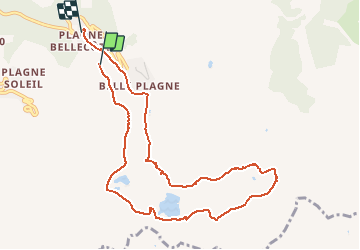
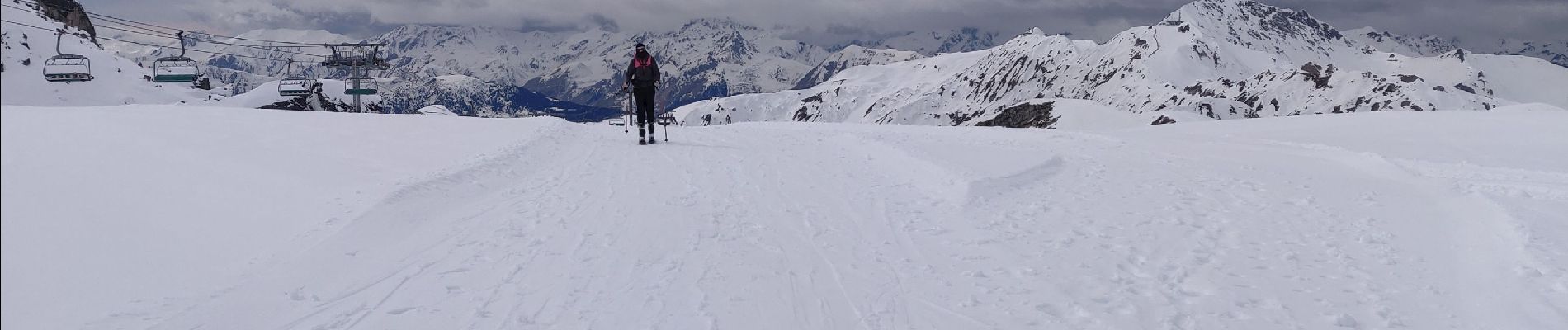
Trail Touring skiing of 9.8 km to be discovered at Auvergne-Rhône-Alpes, Savoy, La Plagne-Tarentaise. This trail is proposed by nave.

Description

Itinéraire à partir de Plagne bellecote vers Roche de Mio à ski de randonnée - quelques passages techniques mais belle randonnée -descente par la piste des Sources

Elevation profile

Photos

Positioning

Country:
France
Region :
Auvergne-Rhône-Alpes
Department/Province :
Savoy
Municipality :
La Plagne-Tarentaise
Location:
Mâcot-la-Plagne
Start:(UTM)
320366 ; 5042136 (32T) N.

Trails nearby

Trail On foot Aime-la-Plagne - Le Mont Jovet - Photo
On foot
GUIDE+

On foot

Medium
Aime-la-Plagne, Auvergne-Rhône-Alpes, Savoy, France
11.1 km | 21 km-effort
4h 45min
Yes
Trail On foot La Plagne-Tarentaise - Les Frasses - Photo
On foot
GUIDE+

On foot

Easy
La Plagne-Tarentaise, Auvergne-Rhône-Alpes, Savoy, France
5.7 km | 7.8 km-effort
1h 45min
No
Trail On foot La Plagne-Tarentaise - Boucle du Carroley - Photo
On foot
GUIDE+

On foot

Easy
La Plagne-Tarentaise, Auvergne-Rhône-Alpes, Savoy, France
4.2 km | 7.5 km-effort
1h 41min
No
Trail On foot La Plagne-Tarentaise - Sentier Découverte Grande Rochette - Photo
On foot
GUIDE+

On foot

Easy
La Plagne-Tarentaise, Auvergne-Rhône-Alpes, Savoy, France
9.2 km | 16.3 km-effort
3h 42min
Yes
Trail On foot La Plagne-Tarentaise - Boucle de Roche de Mio - Photo
On foot
GUIDE+

On foot

Easy
La Plagne-Tarentaise, Auvergne-Rhône-Alpes, Savoy, France
5.6 km | 12.1 km-effort
2h 44min
No
Trail On foot Aime-la-Plagne - Route Balcon - Photo
On foot
GUIDE+

On foot

Easy
Aime-la-Plagne, Auvergne-Rhône-Alpes, Savoy, France
7.4 km | 9.6 km-effort
2h 11min
No
Trail On foot La Plagne-Tarentaise - Le Lac Vert - Photo
On foot
GUIDE+

On foot

Easy
La Plagne-Tarentaise, Auvergne-Rhône-Alpes, Savoy, France
4.6 km | 7 km-effort
1h 36min
Yes
Trail Walking Bozel - Le Mont Jovet - Bozel - Photo
Walking
tracegps

Walking

Difficult
(1)
Bozel, Auvergne-Rhône-Alpes, Savoy, France
17.3 km | 32 km-effort
4h 45min
Yes
Trail Walking La Plagne-Tarentaise - Plagne Soleil, La Grande Rochette, Plagne Centre  - Photo
Walking
GUIDE
lhomme.ph

Walking

Difficult
La Plagne-Tarentaise, Auvergne-Rhône-Alpes, Savoy, France
8.6 km | 14.5 km-effort
2h 57min
No


Close
My subscriptions