Trail Walking Chichilianne - du Pas de l'Aiguille au pas de l'Essaure - Photo

du Pas de l'Aiguille au pas de l'Essaure

 Chafoin
Chafoin

User

© OpenStreetMap contributors
Length
Length
10.7 km
Max alt
Max alt
1845 m
Uphill gradient
Uphill gradient
662 m
Km-Effort
Km-Effort  
19.9 km
Min alt
Min alt
1078 m
Downhill gradient
Downhill gradient
792 m
Boucle
Boucle
No
Creation date :
2021-03-06 15:14:46.591
Updated on :
2021-03-06 15:36:57.655

(0 Reviews)

Walking
Walking
4h31
Difficulty : Medium

Scan this QR Code to open this trail in the SityTrail application

FREE GPS app for hiking

Logo SityTrail SityTrail

IGN / Geographical institutes

Download SityTrail from the App Store Download SityTrail from Google Play

Logo SityTrail SityTrail World

The world is yours!

Download SityTrail from the App Store Download SityTrail from Google Play Download SityTrail on Huawei AppGallery

About

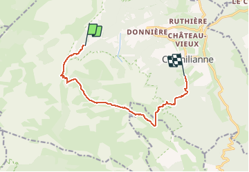
Trail Walking of 10.7 km to be discovered at Auvergne-Rhône-Alpes, Isère, Chichilianne. This trail is proposed by Chafoin.

Description

La montée jusqu'au refuge des Chaumailloux est donnée en 2h et la descente par le pas de l'Essaure en 1h 45 dans le guide Massif du Vercors Royans de S.Sarthou et J.-J Bach .La Richardière Chichilianne : 62,6 km de Grenoble Carte 3236 OT Villard-de-LanS

Elevation profile

Positioning

Country:
France
Region :
Auvergne-Rhône-Alpes
Department/Province :
Isère
Municipality :
Chichilianne
Location:
Unknown
Start:(UTM)
699462 ; 4965627 (31T) N.

Trails nearby

Trail Walking Saint-Michel-les-Portes - Grand Ceymont par la face Sud - Photo
Walking
GUIDE
nadd73

Walking

Difficult
(1)
Saint-Michel-les-Portes, Auvergne-Rhône-Alpes, Isère, France
14.3 km | 31 km-effort
6h 0min
Yes
Trail Walking Châtillon-en-Diois - Combau-TêteChevalière 05-05-2018 - Photo
Walking
Philindy26

Walking

Easy
(4)
Châtillon-en-Diois, Auvergne-Rhône-Alpes, Drôme, France
10.2 km | 17.1 km-effort
4h 0min
Yes
Trail Walking Chichilianne - La Fontaine Pourrie - Hauts Plateaux Sud du Vercors - Photo
Walking
tracegps

Walking

Medium
(2)
Chichilianne, Auvergne-Rhône-Alpes, Isère, France
19.4 km | 33 km-effort
7h 45min
Yes
Trail Walking Gresse-en-Vercors - traversée Sud nord du Grand Veymont  - Photo
Walking
GUIDE
nadd73

Walking

Difficult
Gresse-en-Vercors, Auvergne-Rhône-Alpes, Isère, France
26 km | 40 km-effort
10h 42min
No
Trail Walking Chichilianne - 14923554-Tour du Mont Aiguille - Photo
Walking
Maryma

Walking

Very difficult
(1)
Chichilianne, Auvergne-Rhône-Alpes, Isère, France
17.7 km | 33 km-effort
7h 27min
Yes
Trail Snowshoes Chichilianne - chichilianne archiane - Photo
Snowshoes
jerome-dupont@laposte.net

Snowshoes

Medium
(1)
Chichilianne, Auvergne-Rhône-Alpes, Isère, France
18.9 km | 32 km-effort
8h 0min
No
Trail Walking Chichilianne - Diois 2024 1ère journée  - Photo
Walking
planets

Walking

Medium
Chichilianne, Auvergne-Rhône-Alpes, Isère, France
22 km | 35 km-effort
4h 59min
No
Trail Walking Châtillon-en-Diois - Vallon de Combeau - Photo
Walking
AIGUIER

Walking

Difficult
Châtillon-en-Diois, Auvergne-Rhône-Alpes, Drôme, France
12.2 km | 19.5 km-effort
4h 51min
Yes
Trail Walking Châtillon-en-Diois - la Montagnette par le Grand Pas - Photo
Walking
bymarc26

Walking

Difficult
Châtillon-en-Diois, Auvergne-Rhône-Alpes, Drôme, France
6.7 km | 13.4 km-effort
2h 22min
Yes


Close
My subscriptions