![](/images/other/stat-length.png)
![Trail Walking La Bernerie-en-Retz - Les Tréans - La Bernerie en Retz - Photo](https://media.geolcdn.com/t/1900/400/ext.pjpeg?maxdim=2&url=https%3A%2F%2Fstatic1.geolcdn.com%2Fsiteimages%2Fupload%2Ffiles%2F1553511878bg_sport_marche.png)
Les Tréans - La Bernerie en Retz
Polenade
User
![Length](/images/other/stat-length.png)
Length
9.8 km
![Max alt](https://static1.geolcdn.com/siteimages/upload/files/1508320355ic_sort_altitude_max_24dp.png)
Max alt
41 m
![Uphill gradient](https://static1.geolcdn.com/siteimages/upload/files/1508320355ic_sort_den_pos_24dp.png)
Uphill gradient
66 m
![Km-Effort](/images/other/stat-length.png)
Km-Effort
10.7 km
![Min alt](https://static1.geolcdn.com/siteimages/upload/files/1508320355ic_sort_altitude_min_24dp.png)
Min alt
1 m
![Downhill gradient](https://static1.geolcdn.com/siteimages/upload/files/1508320355ic_sort_den_neg_24dp.png)
Downhill gradient
65 m
![Boucle](https://static1.geolcdn.com/siteimages/upload/files/16400158638029165_repeat_loop_refresh_sync_direction_icon.png)
Boucle
Yes
Creation date :
2021-03-03 16:32:05.994
Updated on :
2021-03-03 16:35:59.687
![Walking](https://static1.geolcdn.com/sitytour/trail-icons/101.png)
2h25
Difficulty : Medium
![Scan this QR Code to open this trail in the SityTrail application](https://capi.geolives.com/qq0zvz2zws4bq2lad0pu/sitytour/trails/2693620/qr.png?size=200)
FREE GPS app for hiking
About
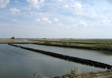
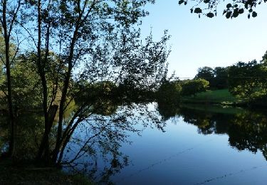
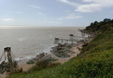
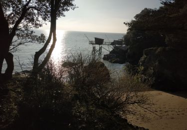
Trail Walking of 9.8 km to be discovered at Pays de la Loire, Loire-Atlantique, La Bernerie-en-Retz. This trail is proposed by Polenade.
Description
Différents visages de la Bernerie en Retz, entre mer et campagne, entre plage et champs. Passage à proximité du moulin des Tréans, bâti au XIIIème siècle
Au départ une variante permet de passer par la plage à marée basse
Positioning
Country:
France
Region :
Pays de la Loire
Department/Province :
Loire-Atlantique
Municipality :
La Bernerie-en-Retz
Location:
Unknown
Start:(Dec)
Start:(UTM)
573067 ; 5214364 (30T) N.
Comments
Trails nearby
![Trail On foot Les Moutiers-en-Retz - Le Collet - Photo](https://media.geolcdn.com/t/375/260/1a57d417-9132-4bf4-870f-21ad0636d79e.jpeg&format=jpg&maxdim=2)
![On foot On foot](https://static1.geolcdn.com/sitytour/trail-icons/100.png)
Le Collet
On foot
Easy
Les Moutiers-en-Retz,
Pays de la Loire,
Loire-Atlantique,
France
![](/images/other/stat-length.png)
9.9 km | 10.5 km-effort
2h 22min
![](https://static1.geolcdn.com/siteimages/upload/files/16400158638029165_repeat_loop_refresh_sync_direction_icon.png)
Yes
![Trail Walking Pornic - LaFontaineAuxBretons-A - Photo](https://media.geolcdn.com/t/375/260/ext.jpg?maxdim=2&url=https%3A%2F%2Fstatic1.geolcdn.com%2Fsiteimages%2Fupload%2Ffiles%2F1553511878bg_sport_marche.png)
![Walking Walking](https://static1.geolcdn.com/sitytour/trail-icons/101.png)
LaFontaineAuxBretons-A
Walking
Medium
(1)
Pornic,
Pays de la Loire,
Loire-Atlantique,
France
![](/images/other/stat-length.png)
9.7 km | 11.1 km-effort
2h 31min
![](https://static1.geolcdn.com/siteimages/upload/files/16400158638029165_repeat_loop_refresh_sync_direction_icon.png)
Yes
![Trail Walking Pornic - LaFontaineAuxBretons-A - Photo](https://media.geolcdn.com/t/375/260/ext.jpg?maxdim=2&url=https%3A%2F%2Fstatic1.geolcdn.com%2Fsiteimages%2Fupload%2Ffiles%2F1553511878bg_sport_marche.png)
![Walking Walking](https://static1.geolcdn.com/sitytour/trail-icons/101.png)
LaFontaineAuxBretons-A
Walking
Easy
(1)
Pornic,
Pays de la Loire,
Loire-Atlantique,
France
![](/images/other/stat-length.png)
10 km | 11.2 km-effort
2h 59min
![](https://static1.geolcdn.com/siteimages/upload/files/16400158638029165_repeat_loop_refresh_sync_direction_icon.png)
Yes
![Trail Walking Pornic - Canal de Haute Perche - Photo](https://media.geolcdn.com/t/375/260/ext.jpg?maxdim=2&url=https%3A%2F%2Fservices.sitytrail.com%2FGeolivesWS%2FDownloadMedia.ashx%3FTrailID%3D771862%26Media%3D27594949-f20c-4a60-8416-85c35d063bd1.jpg)
![Walking Walking](https://static1.geolcdn.com/sitytour/trail-icons/101.png)
Canal de Haute Perche
Walking
Medium
Pornic,
Pays de la Loire,
Loire-Atlantique,
France
![](/images/other/stat-length.png)
9 km | 9.8 km-effort
2h 0min
![](https://static1.geolcdn.com/siteimages/upload/files/16400158638029165_repeat_loop_refresh_sync_direction_icon.png)
Yes
![Trail Walking Pornic - LaFontaineAuxBretons-A - Photo](https://media.geolcdn.com/t/375/260/ext.jpg?maxdim=2&url=https%3A%2F%2Fstatic1.geolcdn.com%2Fsiteimages%2Fupload%2Ffiles%2F1553511878bg_sport_marche.png)
![Walking Walking](https://static1.geolcdn.com/sitytour/trail-icons/101.png)
LaFontaineAuxBretons-A
Walking
Easy
(1)
Pornic,
Pays de la Loire,
Loire-Atlantique,
France
![](/images/other/stat-length.png)
12.1 km | 13.5 km-effort
2h 59min
![](https://static1.geolcdn.com/siteimages/upload/files/16400158638029165_repeat_loop_refresh_sync_direction_icon.png)
Yes
![Trail Walking La Bernerie-en-Retz - Bernerie_Trou de l'enfer - Photo](https://media.geolcdn.com/t/375/260/ext.jpg?maxdim=2&url=https%3A%2F%2Fstatic1.geolcdn.com%2Fsiteimages%2Fupload%2Ffiles%2F1553511878bg_sport_marche.png)
![Walking Walking](https://static1.geolcdn.com/sitytour/trail-icons/101.png)
Bernerie_Trou de l'enfer
Walking
Easy
(1)
La Bernerie-en-Retz,
Pays de la Loire,
Loire-Atlantique,
France
![](/images/other/stat-length.png)
8.4 km | 9.5 km-effort
2h 10min
![](https://static1.geolcdn.com/siteimages/upload/files/16400158638029165_repeat_loop_refresh_sync_direction_icon.png)
Yes
![Trail Walking La Bernerie-en-Retz - La BERNERIE en RETZ - Photo](https://media.geolcdn.com/t/375/260/54207d45-9ea7-4a75-9cd9-948582a4f765.jpg&format=jpg&maxdim=2)
![Walking Walking](https://static1.geolcdn.com/sitytour/trail-icons/101.png)
La BERNERIE en RETZ
Walking
Easy
La Bernerie-en-Retz,
Pays de la Loire,
Loire-Atlantique,
France
![](/images/other/stat-length.png)
9.3 km | 10.7 km-effort
2h 24min
![](https://static1.geolcdn.com/siteimages/upload/files/16400158638029165_repeat_loop_refresh_sync_direction_icon.png)
Yes
![Trail Walking Pornic - pornic - Photo](https://media.geolcdn.com/t/375/260/2af5d4f4-9da6-40b2-888a-8e32a57069e0.jpg&format=jpg&maxdim=2)
![Walking Walking](https://static1.geolcdn.com/sitytour/trail-icons/101.png)
pornic
Walking
Easy
Pornic,
Pays de la Loire,
Loire-Atlantique,
France
![](/images/other/stat-length.png)
7.7 km | 9 km-effort
2h 45min
![](https://static1.geolcdn.com/siteimages/upload/files/16400158638029165_repeat_loop_refresh_sync_direction_icon.png)
No
![Trail Walking Pornic - 2024-01-13 boucle pornic - Photo](https://media.geolcdn.com/t/375/260/62dfdd50-f639-466e-afe0-ec7c6aed7092.jpg&format=jpg&maxdim=2)
![Walking Walking](https://static1.geolcdn.com/sitytour/trail-icons/101.png)
2024-01-13 boucle pornic
Walking
Easy
(1)
Pornic,
Pays de la Loire,
Loire-Atlantique,
France
![](/images/other/stat-length.png)
5.8 km | 6.6 km-effort
1h 8min
![](https://static1.geolcdn.com/siteimages/upload/files/16400158638029165_repeat_loop_refresh_sync_direction_icon.png)
Yes