Trail Walking Saint-Remy-en-Bouzemont-Saint-Genest-et-Isson - Saint Rémy - Photo
 JD51290
JD51290

User

© OpenStreetMap contributors
Length
Length
11.9 km
Max alt
Max alt
136 m
Uphill gradient
Uphill gradient
57 m
Km-Effort
Km-Effort  
12.7 km
Min alt
Min alt
105 m
Downhill gradient
Downhill gradient
57 m
Boucle
Boucle
Yes
Creation date :
2014-12-10 00:00:00.0
Updated on :
2014-12-10 00:00:00.0

(0 Reviews)

Walking
Walking
2h47
Difficulty : Unknown

Scan this QR Code to open this trail in the SityTrail application

FREE GPS app for hiking

Logo SityTrail SityTrail

IGN / Geographical institutes

Download SityTrail from the App Store Download SityTrail from Google Play

Logo SityTrail SityTrail World

The world is yours!

Download SityTrail from the App Store Download SityTrail from Google Play Download SityTrail on Huawei AppGallery

About

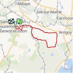
Trail Walking of 11.9 km to be discovered at Grand Est, Marne, Saint-Remy-en-Bouzemont-Saint-Genest-et-Isson. This trail is proposed by JD51290.

Elevation profile

Positioning

Country:
France
Region :
Grand Est
Department/Province :
Marne
Municipality :
Saint-Remy-en-Bouzemont-Saint-Genest-et-Isson
Location:
Unknown
Start:(UTM)
621407 ; 5387364 (31U) N.

Trails nearby

Trail Walking Saint-Remy-en-Bouzemont-Saint-Genest-et-Isson - Chemin de Compostelle, Voie de Vézelay GR654® De Saint Rémy en Bouzemont à Lentilles - Photo
Walking
tracegps

Walking

Difficult
Saint-Remy-en-Bouzemont-Saint-Genest-et-Isson, Grand Est, Marne, France
25 km | 27 km-effort
5h 0min
No
Trail Walking Saint-Remy-en-Bouzemont-Saint-Genest-et-Isson - Via Columbani 13 du 30.08.2024 - Photo
Walking
bene_dictus77

Walking

Medium
Saint-Remy-en-Bouzemont-Saint-Genest-et-Isson, Grand Est, Marne, France
32 km | 35 km-effort
9h 37min
No


Close
My subscriptions