![](/images/other/stat-length.png)
![Trail Walking Montségur - Boucle Col du Séguela - le Taulat 6,4km 556m dén. 3h20 - Photo](https://media.geolcdn.com/t/1900/400/ext.pjpeg?maxdim=2&url=https%3A%2F%2Fstatic1.geolcdn.com%2Fsiteimages%2Fupload%2Ffiles%2F1553511878bg_sport_marche.png)
Boucle Col du Séguela - le Taulat 6,4km 556m dén. 3h20
jopost
User
![Length](/images/other/stat-length.png)
![Max alt](https://static1.geolcdn.com/siteimages/upload/files/1508320355ic_sort_altitude_max_24dp.png)
![Uphill gradient](https://static1.geolcdn.com/siteimages/upload/files/1508320355ic_sort_den_pos_24dp.png)
![Km-Effort](/images/other/stat-length.png)
![Min alt](https://static1.geolcdn.com/siteimages/upload/files/1508320355ic_sort_altitude_min_24dp.png)
![Downhill gradient](https://static1.geolcdn.com/siteimages/upload/files/1508320355ic_sort_den_neg_24dp.png)
![Boucle](https://static1.geolcdn.com/siteimages/upload/files/16400158638029165_repeat_loop_refresh_sync_direction_icon.png)
![Walking](https://static1.geolcdn.com/sitytour/trail-icons/101.png)
3h20
Difficulty : Medium
![Scan this QR Code to open this trail in the SityTrail application](https://capi.geolives.com/qq0zvz2zws4bq2lad0pu/sitytour/trails/2689633/qr.png?size=200)
FREE GPS app for hiking
About
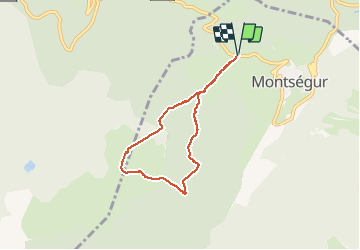
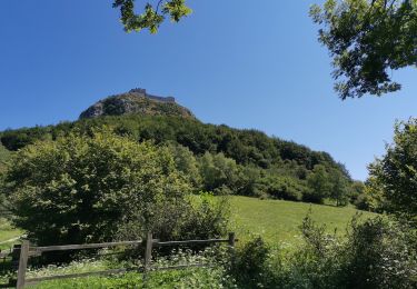
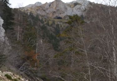
Trail Walking of 6.4 km to be discovered at Occitania, Ariège, Montségur. This trail is proposed by jopost.
Description
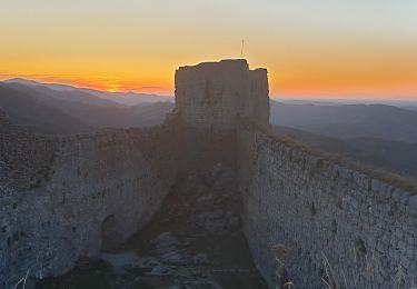
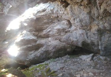
départ depuis le parking du Col du Séguéla (1059m) et montez à droite une vingtaine de minutes jusqu'au panneau "LE PIC", là allez sur la gauche dans le bois et suivez le circuit jaune, en février 2021,beaucoup d'arbres déracinés et couchés sur le chemin, ne vous égarez pas, continuez jusqu'à la sortie du bois et vous verrez le Massif de Tabe avec Le Soularac et le St Barthélémy devant vous après 1h30. N'oubliez pas de partir vers la droite en longeant la crête et vous verrez le Taulat au loin, continuez jusqu'aux panneaux 1584m ( après 2h30 depuis le départ et 4,2km) qui sert de carrefour vers le Pic St Barthélémy ou Moulzoune. Profitez d'être au sommet pour vous restaurer, puis vous irez à droite pour le retour vers Montségur. Vous aurez alors 2,2km de descente pour environ 1h. Au total vous aurez effectué 6,4km pour un dénivelé de 556m et environ 3h30 sans pause. bonne rando.
Positioning
Comments
Trails nearby
![Trail Walking Montferrier - Pic de Saint-Barthélémy - Pla de la Galine - Photo](https://media.geolcdn.com/t/375/260/ext.jpg?maxdim=2&url=https%3A%2F%2Fservices.sitytrail.com%2FGeolivesWS%2FDownloadMedia.ashx%3FTrailID%3D107183%26Media%3D12034_5.jpg)
![Walking Walking](https://static1.geolcdn.com/sitytour/trail-icons/101.png)
Walking
![](/images/other/stat-length.png)
![](https://static1.geolcdn.com/siteimages/upload/files/16400158638029165_repeat_loop_refresh_sync_direction_icon.png)
![Walking Walking](https://static1.geolcdn.com/sitytour/trail-icons/101.png)
Walking
![](/images/other/stat-length.png)
![](https://static1.geolcdn.com/siteimages/upload/files/16400158638029165_repeat_loop_refresh_sync_direction_icon.png)
![Trail Walking Montferrier - découverte du château de montsegur et du village par montferroer - Photo](https://media.geolcdn.com/t/375/260/dbb91943-13a6-421f-97eb-22e28af831f5.jpg&format=jpg&maxdim=2)
![Walking Walking](https://static1.geolcdn.com/sitytour/trail-icons/101.png)
Walking
![](/images/other/stat-length.png)
![](https://static1.geolcdn.com/siteimages/upload/files/16400158638029165_repeat_loop_refresh_sync_direction_icon.png)
![Trail Walking Montségur - 03 et 04 - MONTSEGUR COMUS SORGEAT - Chemin des Bons-Hommes GR107 - Photo](https://media.geolcdn.com/t/375/260/695e8c03-f8ca-4a73-a2fc-4cbbe8211d15.jpg&format=jpg&maxdim=2)
![Walking Walking](https://static1.geolcdn.com/sitytour/trail-icons/101.png)
Walking
![](/images/other/stat-length.png)
![](https://static1.geolcdn.com/siteimages/upload/files/16400158638029165_repeat_loop_refresh_sync_direction_icon.png)
![Trail Walking Montségur - la Frau - Photo](https://media.geolcdn.com/t/375/260/ext.jpg?maxdim=2&url=https%3A%2F%2Fservices.sitytrail.com%2FGeolivesWS%2FDownloadMedia.ashx%3FTrailID%3D1026292%26Media%3Dfix__20180821154103.jpg)
![Walking Walking](https://static1.geolcdn.com/sitytour/trail-icons/101.png)
![Trail Snowshoes Montferrier - Mont d'Olmes - le Planas - Photo](https://media.geolcdn.com/t/375/260/ext.jpg?maxdim=2&url=https%3A%2F%2Fservices.sitytrail.com%2FGeolivesWS%2FDownloadMedia.ashx%3FTrailID%3D696670%26Media%3Dfix__20170211144313.jpg)
![Snowshoes Snowshoes](https://static1.geolcdn.com/sitytour/trail-icons/504.png)
Snowshoes
![](/images/other/stat-length.png)
![](https://static1.geolcdn.com/siteimages/upload/files/16400158638029165_repeat_loop_refresh_sync_direction_icon.png)
![Trail Walking Montségur - Sentier Cathare - De Montségur à Comus - Photo](https://media.geolcdn.com/t/375/260/ext.jpg?maxdim=2&url=https%3A%2F%2Fservices.sitytrail.com%2FGeolivesWS%2FDownloadMedia.ashx%3FTrailID%3D106621%26Media%3D11231_6.jpg)
![Walking Walking](https://static1.geolcdn.com/sitytour/trail-icons/101.png)
Walking
![](/images/other/stat-length.png)
![](https://static1.geolcdn.com/siteimages/upload/files/16400158638029165_repeat_loop_refresh_sync_direction_icon.png)
![Trail Walking Montségur - CLA09-08 Château de Montségur - Photo](https://media.geolcdn.com/t/375/260/769bb975-7d09-46b3-a7d3-7cc8a1c4ef80.jpg&format=jpg&maxdim=2)
![Walking Walking](https://static1.geolcdn.com/sitytour/trail-icons/101.png)
Walking
![](/images/other/stat-length.png)
![](https://static1.geolcdn.com/siteimages/upload/files/16400158638029165_repeat_loop_refresh_sync_direction_icon.png)
![Trail Other activity Montségur - roc punchut grotte des foyers - Photo](https://media.geolcdn.com/t/375/260/a4b55b03-ce46-46d1-8d53-1f5741836163.jpg&format=jpg&maxdim=2)
![Other activity Other activity](https://static1.geolcdn.com/sitytour/trail-icons/900.png)
Other activity
![](/images/other/stat-length.png)
![](https://static1.geolcdn.com/siteimages/upload/files/16400158638029165_repeat_loop_refresh_sync_direction_icon.png)