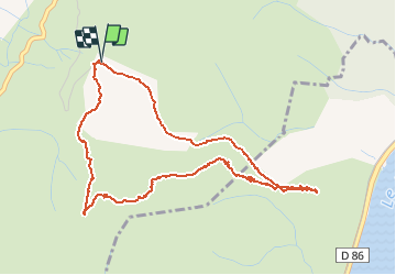
![](/images/other/stat-length.png)
![Trail Walking Rompon - Le couvent des chèvres par le vieux Rompon - Photo](https://media.geolcdn.com/t/1900/400/ext.pjpeg?maxdim=2&url=https%3A%2F%2Fmedia.geolcdn.com%2Ff%2F556465a4-326c-46b4-8d98-dedf95001abe.jpg)
Le couvent des chèvres par le vieux Rompon
crocau
User
![Length](/images/other/stat-length.png)
![Max alt](https://static1.geolcdn.com/siteimages/upload/files/1508320355ic_sort_altitude_max_24dp.png)
![Uphill gradient](https://static1.geolcdn.com/siteimages/upload/files/1508320355ic_sort_den_pos_24dp.png)
![Km-Effort](/images/other/stat-length.png)
![Min alt](https://static1.geolcdn.com/siteimages/upload/files/1508320355ic_sort_altitude_min_24dp.png)
![Downhill gradient](https://static1.geolcdn.com/siteimages/upload/files/1508320355ic_sort_den_neg_24dp.png)
![Boucle](https://static1.geolcdn.com/siteimages/upload/files/16400158638029165_repeat_loop_refresh_sync_direction_icon.png)
![Walking](https://static1.geolcdn.com/sitytour/trail-icons/101.png)
1h54
Difficulty : Very easy
![Scan this QR Code to open this trail in the SityTrail application](https://capi.geolives.com/qq0zvz2zws4bq2lad0pu/sitytour/trails/2689390/qr.png?size=200)
FREE GPS app for hiking
About
Trail Walking of 5.2 km to be discovered at Auvergne-Rhône-Alpes, Ardèche, Rompon. This trail is proposed by crocau.
Description
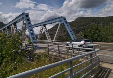
Se rendre au hameau du Vieux Rompon et se garer sur l'aire aménagée en bordure de route.
(D/A) Du parking, suivre la route qui passe devant la chapelle. Traverser le hameau et poursuivre par le chemin de terre jusqu'à un portail en fer.
Passer celui-ci en prenant soin de le refermer derrière vous. Prendre en face légèrement sur la droite le sentier qui monte fort (On peut également suivre le chemin forestier à gauche, moins pentu) et rejoindre le chemin forestier. Continuer à droite, laisser un départ à droite et rejoindre le prochain croisement avec trois chemins.
Prendre à gauche et suivre le chemin de terre jusqu'à un bel arbre isolé.
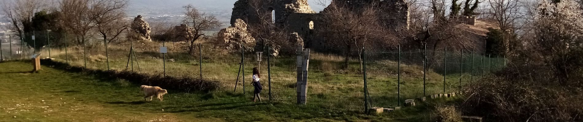
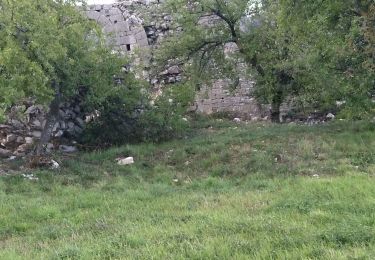
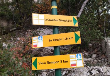
Poursuivre à gauche, droit sur un pylône de ligne électrique et descendre le long d'un grillage et rejoindre un sentier que vous suivrez à droite jusqu'au Couvent des Chèvres.
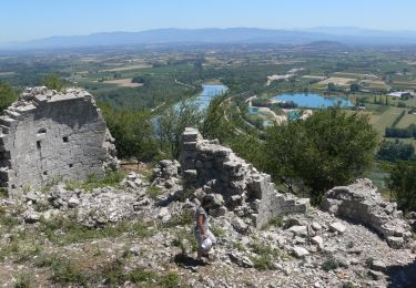
Repartir en suivant le chemin forestier qui passe sur le coteau, au-dessus de la carrière. Laisser le départ de piste sur la droite et continuer jusqu'à un portail à contourner par la droite (refermer le portillon). Rejoindre le parking au hameau du Vieux Rompon
Positioning
Comments
Trails nearby
![Trail Walking La Voulte-sur-Rhône - La Voulte Via-Rhôna 7KM - Photo](https://media.geolcdn.com/t/375/260/ext.jpg?maxdim=2&url=https%3A%2F%2Fmedia.geolcdn.com%2Ff%2F620eea2b-7c65-44be-a1eb-b1fcfc74c039.jpg)
![Walking Walking](https://static1.geolcdn.com/sitytour/trail-icons/101.png)
Walking
![](/images/other/stat-length.png)
![](https://static1.geolcdn.com/siteimages/upload/files/16400158638029165_repeat_loop_refresh_sync_direction_icon.png)
![Trail Walking La Voulte-sur-Rhône - La Voulte ViaRhona 6,5km - Photo](https://media.geolcdn.com/t/375/260/ext.jpg?maxdim=2&url=https%3A%2F%2Fmedia.geolcdn.com%2Ff%2F9614651f-4007-44ca-9c3c-97a6e4ce7270.jpg)
![Walking Walking](https://static1.geolcdn.com/sitytour/trail-icons/101.png)
Walking
![](/images/other/stat-length.png)
![](https://static1.geolcdn.com/siteimages/upload/files/16400158638029165_repeat_loop_refresh_sync_direction_icon.png)
![Trail Road bike La Voulte-sur-Rhône - 07 la voulte privas voie payre - Photo](https://media.geolcdn.com/t/375/260/ext.jpg?maxdim=2&url=https%3A%2F%2Fmedia.geolcdn.com%2Ff%2Fa0a6e94a-154b-402d-a870-cb27302170ee.jpg)
![Road bike Road bike](https://static1.geolcdn.com/sitytour/trail-icons/201.png)
Road bike
![](/images/other/stat-length.png)
![](https://static1.geolcdn.com/siteimages/upload/files/16400158638029165_repeat_loop_refresh_sync_direction_icon.png)
![Trail Walking Le Pouzin - le Pouzin le couvent des Chèvres vieux Rompon - Photo](https://media.geolcdn.com/t/375/260/ext.jpg?maxdim=2&url=https%3A%2F%2Fmedia.geolcdn.com%2Ff%2F2a1fff91-e20b-436c-b942-1b82467f68e9.jpg)
![Walking Walking](https://static1.geolcdn.com/sitytour/trail-icons/101.png)
Walking
![](/images/other/stat-length.png)
![](https://static1.geolcdn.com/siteimages/upload/files/16400158638029165_repeat_loop_refresh_sync_direction_icon.png)
![Trail Walking Saint-Julien-en-Saint-Alban - saint julien en Saint Alban-Le Pouzain 07 - Photo](https://media.geolcdn.com/t/375/260/ext.jpg?maxdim=2&url=https%3A%2F%2Fmedia.geolcdn.com%2Ff%2F1e4688d6-1dfb-4151-9a3f-8e9b2b55e268.jpg)
![Walking Walking](https://static1.geolcdn.com/sitytour/trail-icons/101.png)
Walking
![](/images/other/stat-length.png)
![](https://static1.geolcdn.com/siteimages/upload/files/16400158638029165_repeat_loop_refresh_sync_direction_icon.png)
![Trail Walking Le Pouzin - 07 pouzin couvent des chèvres zel - Photo](https://media.geolcdn.com/t/375/260/ext.jpg?maxdim=2&url=https%3A%2F%2Fmedia.geolcdn.com%2Ff%2F27e3009c-a2c9-4a5b-9e79-278e69de3846.jpg)
![Walking Walking](https://static1.geolcdn.com/sitytour/trail-icons/101.png)
Walking
![](/images/other/stat-length.png)
![](https://static1.geolcdn.com/siteimages/upload/files/16400158638029165_repeat_loop_refresh_sync_direction_icon.png)
![Trail Walking Flaviac - Flaviac Serre de l'Eglise 15km - Photo](https://media.geolcdn.com/t/375/260/ext.jpg?maxdim=2&url=https%3A%2F%2Fmedia.geolcdn.com%2Ff%2F6203886c-16c3-47c9-ace2-85f55b06e3cd.jpg)
![Walking Walking](https://static1.geolcdn.com/sitytour/trail-icons/101.png)
Walking
![](/images/other/stat-length.png)
![](https://static1.geolcdn.com/siteimages/upload/files/16400158638029165_repeat_loop_refresh_sync_direction_icon.png)
![Trail Walking Le Pouzin - Balcon de l'Ouvèze - Photo](https://media.geolcdn.com/t/375/260/ext.jpg?maxdim=2&url=https%3A%2F%2Fmedia.geolcdn.com%2Ff%2F60f01936-1b34-45ee-ae81-570080e25fbf.jpg)
![Walking Walking](https://static1.geolcdn.com/sitytour/trail-icons/101.png)
Walking
![](/images/other/stat-length.png)
![](https://static1.geolcdn.com/siteimages/upload/files/16400158638029165_repeat_loop_refresh_sync_direction_icon.png)
![Trail Walking Le Pouzin - 07 balcon Ouvèze pouzin - Photo](https://media.geolcdn.com/t/375/260/ext.jpg?maxdim=2&url=https%3A%2F%2Fmedia.geolcdn.com%2Ff%2Fe1f893af-61d3-4cd8-a418-b5cde15229b8.jpg)
![Walking Walking](https://static1.geolcdn.com/sitytour/trail-icons/101.png)
Walking
![](/images/other/stat-length.png)
![](https://static1.geolcdn.com/siteimages/upload/files/16400158638029165_repeat_loop_refresh_sync_direction_icon.png)