Trail Walking Chanonat - Chanonat_Montagne_Serre - Photo
 jagarnier
jagarnier

User GUIDE

© OpenStreetMap contributors
Length
Length
13.1 km
Max alt
Max alt
722 m
Uphill gradient
Uphill gradient
351 m
Km-Effort
Km-Effort  
17.8 km
Min alt
Min alt
479 m
Downhill gradient
Downhill gradient
351 m
Boucle
Boucle
Yes
Creation date :
2021-02-25 05:28:56.626
Updated on :
2023-09-08 05:15:04.106

(2 Reviews)

Walking
Walking
4h00
Difficulty : Medium

Scan this QR Code to open this trail in the SityTrail application

FREE GPS app for hiking

Logo SityTrail SityTrail

IGN / Geographical institutes

Download SityTrail from the App Store Download SityTrail from Google Play

Logo SityTrail SityTrail World

The world is yours!

Download SityTrail from the App Store Download SityTrail from Google Play Download SityTrail on Huawei AppGallery

About

Trail Walking of 13.1 km to be discovered at Auvergne-Rhône-Alpes, Puy-de-Dôme, Chanonat. This trail is proposed by jagarnier.

Description

Au départ de Chanonat, joli village médiéval, vous flânerez le long de l'Auzon avant de grimper sur les hauteurs de la Montagne de la Serre. Ce relief inversé est né de l'érosion des roches sédimentaires de la plaine alentour par les rivières, dont l'Auzon, sur son versant Nord.

Elevation profile

Photos

Positioning

Country:
France
Region :
Auvergne-Rhône-Alpes
Department/Province :
Puy-de-Dôme
Municipality :
Chanonat
Location:
Unknown
Start:(UTM)
507628 ; 5060128 (31T) N.

Comments

Please log in to post a review or rate the element


Trails nearby

Trail Walking Ceyrat - Ceyrat_Tour_Montrognon - Photo
Walking
GUIDE
jagarnier

Walking

Easy
(1)
Ceyrat, Auvergne-Rhône-Alpes, Puy-de-Dôme, France
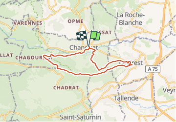
7.2 km | 9.3 km-effort
2h 15min
Yes
Trail Walking Romagnat - Le Puy Giroux près d'Opme - Photo
Walking
tracegps

Walking

Easy
(1)
Romagnat, Auvergne-Rhône-Alpes, Puy-de-Dôme, France
6.6 km | 9.2 km-effort
1h 45min
Yes
Trail On foot Saint-Saturnin - Les Cirques de longevette et des Cotes - Photo
On foot
GUIDE+

On foot

Easy
Saint-Saturnin, Auvergne-Rhône-Alpes, Puy-de-Dôme, France
5.4 km | 7.1 km-effort
1h 37min
Yes
Trail On foot Saint-Amant-Tallende - Le Puy de Peyronere - Photo
On foot
GUIDE+

On foot

Easy
Saint-Amant-Tallende, Auvergne-Rhône-Alpes, Puy-de-Dôme, France
9.5 km | 13 km-effort
2h 57min
Yes
Trail On foot Chanonat - Le Crest - Photo
On foot
GUIDE+

On foot

Easy
Chanonat, Auvergne-Rhône-Alpes, Puy-de-Dôme, France
10.7 km | 14.7 km-effort
3h 20min
Yes
Trail On foot Ceyrat - Redon - Photo
On foot
GUIDE+

On foot

Easy
Ceyrat, Auvergne-Rhône-Alpes, Puy-de-Dôme, France
8.4 km | 11.4 km-effort
2h 35min
Yes
Trail On foot Ceyrat - Les Gorges de l'Artiere - Photo
On foot
GUIDE+

On foot

Easy
Ceyrat, Auvergne-Rhône-Alpes, Puy-de-Dôme, France
6.9 km | 10.4 km-effort
2h 22min
Yes
Trail On foot Chanonat - Le Puy de Jussat - Photo
On foot
GUIDE+

On foot

Easy
Chanonat, Auvergne-Rhône-Alpes, Puy-de-Dôme, France
4.7 km | 6.8 km-effort
1h 32min
Yes
Trail On foot La Roche-Blanche - Le Plateau de Gergovie - Photo
On foot
GUIDE+

On foot

Easy
La Roche-Blanche, Auvergne-Rhône-Alpes, Puy-de-Dôme, France
3.5 km | 4.4 km-effort
59min
Yes


Close
My subscriptions