Trail Walking La Cadière-d'Azur - la Cadière d azur st Cyr sur mer - Photo

la Cadière d azur st Cyr sur mer

 chrifor
chrifor

User

© OpenStreetMap contributors
Length
Length
16.4 km
Max alt
Max alt
226 m
Uphill gradient
Uphill gradient
481 m
Km-Effort
Km-Effort  
23 km
Min alt
Min alt
22 m
Downhill gradient
Downhill gradient
481 m
Boucle
Boucle
Yes
Creation date :
2021-02-24 08:39:31.413
Updated on :
2021-02-25 10:34:40.132

(1 Reviews)

Walking
Walking
5h52
Difficulty : Medium

Scan this QR Code to open this trail in the SityTrail application

FREE GPS app for hiking

Logo SityTrail SityTrail

IGN / Geographical institutes

Download SityTrail from the App Store Download SityTrail from Google Play

Logo SityTrail SityTrail World

The world is yours!

Download SityTrail from the App Store Download SityTrail from Google Play Download SityTrail on Huawei AppGallery

About

Trail Walking of 16.4 km to be discovered at Provence-Alpes-Côte d'Azur, Var, La Cadière-d'Azur. This trail is proposed by chrifor.

Description

Randonnée (parcourue) agréable entre pinède, vignes et vue sur la sainte Baume et la mer ...si la brume marine n'est pas de la fête!

Elevation profile

Photos

Positioning

Country:
France
Region :
Provence-Alpes-Côte d'Azur
Department/Province :
Var
Municipality :
La Cadière-d'Azur
Location:
Unknown
Start:(UTM)
723277 ; 4785568 (31T) N.

Comments

Please log in to post a review or rate the element


Trails nearby

Trail Walking Saint-Cyr-sur-Mer - St Cyr  - Bandol - Photo
Walking
kephas

Walking

Medium
(1)
Saint-Cyr-sur-Mer, Provence-Alpes-Côte d'Azur, Var, France
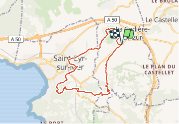
16.1 km | 21 km-effort
4h 53min
No
Trail Walking Saint-Cyr-sur-Mer - Port d'Alon - Bandol - Port d'Alon - Photo
Walking
tracegps

Walking

Medium
(1)
Saint-Cyr-sur-Mer, Provence-Alpes-Côte d'Azur, Var, France
7.7 km | 9.9 km-effort
2h 0min
Yes
Trail Walking Saint-Cyr-sur-Mer - Le Port d'Alon - Photo
Walking
tracegps

Walking

Medium
(2)
Saint-Cyr-sur-Mer, Provence-Alpes-Côte d'Azur, Var, France
9.4 km | 12.8 km-effort
3h 0min
Yes
Trail Nordic walking La Cadière-d'Azur - 20220329_La Cadière d'Azur - Photo
Nordic walking
Marcsaintcyr

Nordic walking

Very easy
(1)
La Cadière-d'Azur, Provence-Alpes-Côte d'Azur, Var, France
6.8 km | 8.6 km-effort
1h 30min
Yes
Trail Nordic walking La Cadière-d'Azur - 20220329_La Cadière d'Azur - Photo
Nordic walking
Marcsaintcyr

Nordic walking

Very easy
(1)
La Cadière-d'Azur, Provence-Alpes-Côte d'Azur, Var, France
6.8 km | 8.6 km-effort
1h 30min
Yes
Trail Walking Saint-Cyr-sur-Mer - le sentier littoral de la Madrague et la colline de sable - Photo
Walking
GUIDE
amiral13

Walking

Easy
(1)
Saint-Cyr-sur-Mer, Provence-Alpes-Côte d'Azur, Var, France
13 km | 18.7 km-effort
5h 20min
Yes
Trail Walking Le Castellet - Traversée du Gros Cerveau - forteresses et grotte - Photo
Walking
Bart2015

Walking

Difficult
Le Castellet, Provence-Alpes-Côte d'Azur, Var, France
11.8 km | 18.3 km-effort
4h 9min
Yes
Trail Walking Le Castellet - Roche Redonne depuis Ste Anne du Castelet - Photo
Walking
Daniel.BRUN-PICARD

Walking

Difficult
Le Castellet, Provence-Alpes-Côte d'Azur, Var, France
11 km | 15.7 km-effort
3h 34min
Yes
Trail sport Saint-Cyr-sur-Mer - Sentier du littoral et des vigne - Photo
sport
lviallet

sport

Very easy
Saint-Cyr-sur-Mer, Provence-Alpes-Côte d'Azur, Var, France
10 km | 13.1 km-effort
Unknown
Yes


Close
My subscriptions