![](/images/other/stat-length.png)
![Trail Hybrid bike Bagnoles-de-l'Orne-Normandie - bagnoles de l'ore - Photo](https://media.geolcdn.com/t/1900/400/4eea9336-edc2-458e-9d5f-3a5eced18dc8.jpg&format=pjpeg&maxdim=2)
bagnoles de l'ore
valetg
User
![Length](/images/other/stat-length.png)
Length
18.6 km
![Max alt](https://static1.geolcdn.com/siteimages/upload/files/1508320355ic_sort_altitude_max_24dp.png)
Max alt
225 m
![Uphill gradient](https://static1.geolcdn.com/siteimages/upload/files/1508320355ic_sort_den_pos_24dp.png)
Uphill gradient
214 m
![Km-Effort](/images/other/stat-length.png)
Km-Effort
22 km
![Min alt](https://static1.geolcdn.com/siteimages/upload/files/1508320355ic_sort_altitude_min_24dp.png)
Min alt
147 m
![Downhill gradient](https://static1.geolcdn.com/siteimages/upload/files/1508320355ic_sort_den_neg_24dp.png)
Downhill gradient
218 m
![Boucle](https://static1.geolcdn.com/siteimages/upload/files/16400158638029165_repeat_loop_refresh_sync_direction_icon.png)
Boucle
Yes
Creation date :
2021-02-24 11:20:23.624
Updated on :
2021-02-24 13:41:32.095
![Hybrid bike](https://static1.geolcdn.com/sitytour/trail-icons/203.png)
1h41
Difficulty : Easy
![Scan this QR Code to open this trail in the SityTrail application](https://capi.geolives.com/qq0zvz2zws4bq2lad0pu/sitytour/trails/2683314/qr.png?size=200)
FREE GPS app for hiking
About
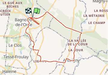
Trail Hybrid bike of 18.6 km to be discovered at Normandy, Orne, Bagnoles-de-l'Orne-Normandie. This trail is proposed by valetg.
Description
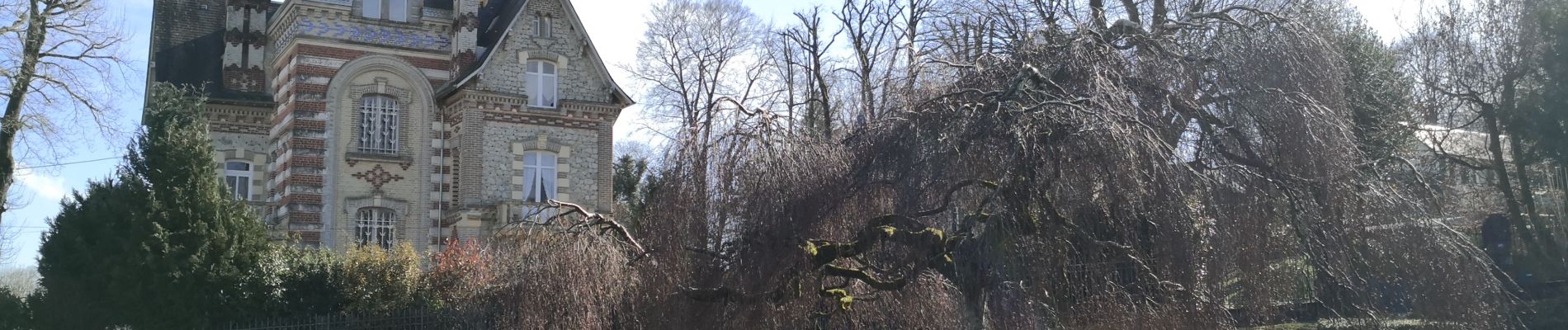
un tour dans la forêt, puis la campagne pour finir au cœur de la ville thermale de bagnoles de l'Orne et ses maisons somptueuses. une curiosité
Positioning
Country:
France
Region :
Normandy
Department/Province :
Orne
Municipality :
Bagnoles-de-l'Orne-Normandie
Location:
Bagnoles-de-l'Orne
Start:(Dec)
Start:(UTM)
690940 ; 5381478 (30U) N.
Comments
Trails nearby
![Trail On foot Rives-d'Andaine - Sentier des Templiers - Photo](https://media.geolcdn.com/t/375/260/7f8f2913-590f-4c31-b4e9-64954dd46906.jpeg&format=jpg&maxdim=2)
![On foot On foot](https://static1.geolcdn.com/sitytour/trail-icons/100.png)
Sentier des Templiers
On foot
Easy
Rives-d'Andaine,
Normandy,
Orne,
France
![](/images/other/stat-length.png)
4.9 km | 6.2 km-effort
1h 23min
![](https://static1.geolcdn.com/siteimages/upload/files/16400158638029165_repeat_loop_refresh_sync_direction_icon.png)
No
![Trail Walking Bagnoles-de-l'Orne-Normandie - Saint Ortaire - Photo](https://media.geolcdn.com/t/375/260/ext.jpg?maxdim=2&url=https%3A%2F%2Fstatic1.geolcdn.com%2Fsiteimages%2Fupload%2Ffiles%2F1553511878bg_sport_marche.png)
![Walking Walking](https://static1.geolcdn.com/sitytour/trail-icons/101.png)
Saint Ortaire
Walking
Difficult
(1)
Bagnoles-de-l'Orne-Normandie,
Normandy,
Orne,
France
![](/images/other/stat-length.png)
5.5 km | 6.9 km-effort
1h 39min
![](https://static1.geolcdn.com/siteimages/upload/files/16400158638029165_repeat_loop_refresh_sync_direction_icon.png)
Yes
![Trail Walking Bagnoles-de-l'Orne-Normandie - Forêt d'Andaine - Photo](https://media.geolcdn.com/t/375/260/4445009f-5e34-4cf0-9270-1184d385e215.jpg&format=jpg&maxdim=2)
![Walking Walking](https://static1.geolcdn.com/sitytour/trail-icons/101.png)
Forêt d'Andaine
Walking
Easy
Bagnoles-de-l'Orne-Normandie,
Normandy,
Orne,
France
![](/images/other/stat-length.png)
3.6 km | 4.2 km-effort
2h 0min
![](https://static1.geolcdn.com/siteimages/upload/files/16400158638029165_repeat_loop_refresh_sync_direction_icon.png)
No
![Trail On foot Bagnoles-de-l'Orne-Normandie - Les Arbres remarquables de Bagnoles-de-l'Orne - Photo](https://media.geolcdn.com/t/375/260/3f5af4f6-b5c2-468d-a381-1ea1dcd7f8d4.jpeg&format=jpg&maxdim=2)
![On foot On foot](https://static1.geolcdn.com/sitytour/trail-icons/100.png)
Les Arbres remarquables de Bagnoles-de-l'Orne
On foot
Easy
Bagnoles-de-l'Orne-Normandie,
Normandy,
Orne,
France
![](/images/other/stat-length.png)
7.7 km | 9 km-effort
2h 2min
![](https://static1.geolcdn.com/siteimages/upload/files/16400158638029165_repeat_loop_refresh_sync_direction_icon.png)
Yes
![Trail On foot Bagnoles-de-l'Orne-Normandie - Bagnoles-de-l'Orne - Photo](https://media.geolcdn.com/t/375/260/352c0479-80dd-4a7d-ade5-52d7e1895bb3.jpeg&format=jpg&maxdim=2)
![On foot On foot](https://static1.geolcdn.com/sitytour/trail-icons/100.png)
Bagnoles-de-l'Orne
On foot
Easy
Bagnoles-de-l'Orne-Normandie,
Normandy,
Orne,
France
![](/images/other/stat-length.png)
8.2 km | 9.7 km-effort
2h 11min
![](https://static1.geolcdn.com/siteimages/upload/files/16400158638029165_repeat_loop_refresh_sync_direction_icon.png)
No
![Trail On foot La Ferté-Macé - Circuit des Bornes Cavalières - Photo](https://media.geolcdn.com/t/375/260/ae4572a0-be41-42e4-9cb7-abcf5f5905ac.jpeg&format=jpg&maxdim=2)
![On foot On foot](https://static1.geolcdn.com/sitytour/trail-icons/100.png)
Circuit des Bornes Cavalières
On foot
Easy
La Ferté-Macé,
Normandy,
Orne,
France
![](/images/other/stat-length.png)
8 km | 9.5 km-effort
2h 10min
![](https://static1.geolcdn.com/siteimages/upload/files/16400158638029165_repeat_loop_refresh_sync_direction_icon.png)
No
![Trail Walking Magny-le-Désert - Andaines - Villiers - Photo](https://media.geolcdn.com/t/375/260/ext.jpg?maxdim=2&url=https%3A%2F%2Fstatic1.geolcdn.com%2Fsiteimages%2Fupload%2Ffiles%2F1553511878bg_sport_marche.png)
![Walking Walking](https://static1.geolcdn.com/sitytour/trail-icons/101.png)
Andaines - Villiers
Walking
Medium
(1)
Magny-le-Désert,
Normandy,
Orne,
France
![](/images/other/stat-length.png)
10.6 km | 13.6 km-effort
2h 36min
![](https://static1.geolcdn.com/siteimages/upload/files/16400158638029165_repeat_loop_refresh_sync_direction_icon.png)
Yes
![Trail Walking Bagnoles-de-l'Orne-Normandie - Bagnoles de l' orne - Photo](https://media.geolcdn.com/t/375/260/fa0660f3-37d7-48ea-8a93-ad724fc5fdf8.jpg&format=jpg&maxdim=2)
![Walking Walking](https://static1.geolcdn.com/sitytour/trail-icons/101.png)
Bagnoles de l' orne
Walking
Very easy
Bagnoles-de-l'Orne-Normandie,
Normandy,
Orne,
France
![](/images/other/stat-length.png)
4.8 km | 6.1 km-effort
1h 49min
![](https://static1.geolcdn.com/siteimages/upload/files/16400158638029165_repeat_loop_refresh_sync_direction_icon.png)
Yes
![Trail Walking Bagnoles-de-l'Orne-Normandie - bagnole de l orne - Photo](https://media.geolcdn.com/t/375/260/43a8163c-0967-482d-b4a8-4e78d64fb14a.jpg&format=jpg&maxdim=2)
![Walking Walking](https://static1.geolcdn.com/sitytour/trail-icons/101.png)
bagnole de l orne
Walking
Medium
Bagnoles-de-l'Orne-Normandie,
Normandy,
Orne,
France
![](/images/other/stat-length.png)
8.2 km | 10 km-effort
4h 5min
![](https://static1.geolcdn.com/siteimages/upload/files/16400158638029165_repeat_loop_refresh_sync_direction_icon.png)
Yes