![](/images/other/stat-length.png)
![Trail Walking Six-Fours-les-Plages - Cap Sicié - Notre Dame du Mai - Six fours - Photo](https://media.geolcdn.com/t/1900/400/5d40a7c9-6bdb-4d87-9016-02770321b032.jpg&format=pjpeg&maxdim=2)
Cap Sicié - Notre Dame du Mai - Six fours
affinetataille
User GUIDE
![Length](/images/other/stat-length.png)
Length
8.1 km
![Max alt](https://static1.geolcdn.com/siteimages/upload/files/1508320355ic_sort_altitude_max_24dp.png)
Max alt
339 m
![Uphill gradient](https://static1.geolcdn.com/siteimages/upload/files/1508320355ic_sort_den_pos_24dp.png)
Uphill gradient
397 m
![Km-Effort](/images/other/stat-length.png)
Km-Effort
13.4 km
![Min alt](https://static1.geolcdn.com/siteimages/upload/files/1508320355ic_sort_altitude_min_24dp.png)
Min alt
103 m
![Downhill gradient](https://static1.geolcdn.com/siteimages/upload/files/1508320355ic_sort_den_neg_24dp.png)
Downhill gradient
398 m
![Boucle](https://static1.geolcdn.com/siteimages/upload/files/16400158638029165_repeat_loop_refresh_sync_direction_icon.png)
Boucle
Yes
Creation date :
2021-02-24 07:45:20.195
Updated on :
2022-10-18 12:30:52.996
![Walking](https://static1.geolcdn.com/sitytour/trail-icons/101.png)
3h53
Difficulty : Medium
![Scan this QR Code to open this trail in the SityTrail application](https://capi.geolives.com/qq0zvz2zws4bq2lad0pu/sitytour/trails/2683156/qr.png?size=200)
FREE GPS app for hiking
About
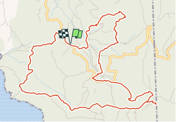
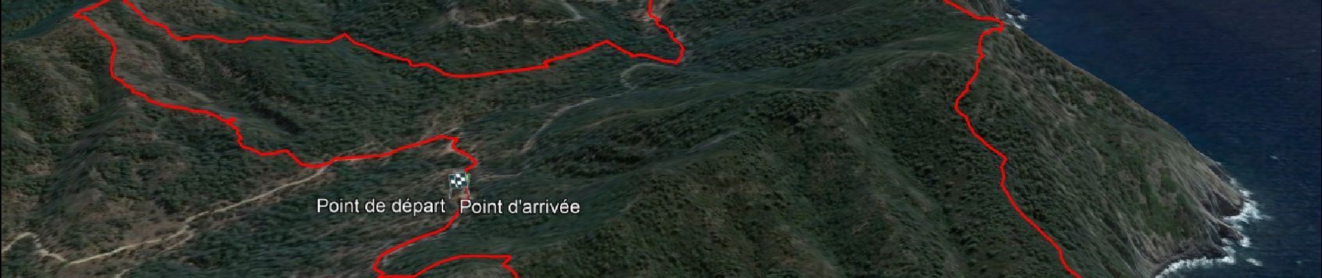
Trail Walking of 8.1 km to be discovered at Provence-Alpes-Côte d'Azur, Var, Six-Fours-les-Plages. This trail is proposed by affinetataille.
Description
Petite boucle avec peu de difficultés.
Une montée et une descente un peu "raides" mais courtes.
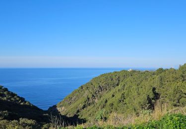
De superbes points de vue.
Positioning
Country:
France
Region :
Provence-Alpes-Côte d'Azur
Department/Province :
Var
Municipality :
Six-Fours-les-Plages
Location:
Unknown
Start:(Dec)
Start:(UTM)
730638 ; 4771468 (31T) N.
Comments
Trails nearby
![Trail Walking Six-Fours-les-Plages - ND de Pepiole via colline du fort de Six-Fours, retour par Les Lônes - Photo](https://media.geolcdn.com/t/375/260/1379151f-75a9-4587-8d69-64d0542e06ca.jpg&format=jpg&maxdim=2)
![Walking Walking](https://static1.geolcdn.com/sitytour/trail-icons/101.png)
ND de Pepiole via colline du fort de Six-Fours, retour par Les Lônes
Walking
Easy
(1)
Six-Fours-les-Plages,
Provence-Alpes-Côte d'Azur,
Var,
France
![](/images/other/stat-length.png)
8.2 km | 10.7 km-effort
3h 0min
![](https://static1.geolcdn.com/siteimages/upload/files/16400158638029165_repeat_loop_refresh_sync_direction_icon.png)
Yes
![Trail Walking Six-Fours-les-Plages - Le sentier du littoral - Photo](https://media.geolcdn.com/t/375/260/b906d75c-22ca-4676-a4ea-efd131997cad.jpeg&format=jpg&maxdim=2)
![Walking Walking](https://static1.geolcdn.com/sitytour/trail-icons/101.png)
Le sentier du littoral
Walking
Difficult
(1)
Six-Fours-les-Plages,
Provence-Alpes-Côte d'Azur,
Var,
France
![](/images/other/stat-length.png)
11 km | 15.8 km-effort
3h 23min
![](https://static1.geolcdn.com/siteimages/upload/files/16400158638029165_repeat_loop_refresh_sync_direction_icon.png)
Yes
![Trail Walking Six-Fours-les-Plages - ND de Pepiole via colline du fort de Six-Fours - Photo](https://media.geolcdn.com/t/375/260/1379151f-75a9-4587-8d69-64d0542e06ca.jpg&format=jpg&maxdim=2)
![Walking Walking](https://static1.geolcdn.com/sitytour/trail-icons/101.png)
ND de Pepiole via colline du fort de Six-Fours
Walking
Easy
(1)
Six-Fours-les-Plages,
Provence-Alpes-Côte d'Azur,
Var,
France
![](/images/other/stat-length.png)
8.7 km | 12.3 km-effort
3h 0min
![](https://static1.geolcdn.com/siteimages/upload/files/16400158638029165_repeat_loop_refresh_sync_direction_icon.png)
Yes
![Trail Walking La Seyne-sur-Mer - fabregas parking du bœuf, plage des nudistes, sémaphore, notre dame de mai. - Photo](https://media.geolcdn.com/t/375/260/d2496b6d-773d-4991-9a61-fe4c8adf1522.jpg&format=jpg&maxdim=2)
![Walking Walking](https://static1.geolcdn.com/sitytour/trail-icons/101.png)
fabregas parking du bœuf, plage des nudistes, sémaphore, notre dame de mai.
Walking
Medium
(3)
La Seyne-sur-Mer,
Provence-Alpes-Côte d'Azur,
Var,
France
![](/images/other/stat-length.png)
10.2 km | 16.3 km-effort
2h 52min
![](https://static1.geolcdn.com/siteimages/upload/files/16400158638029165_repeat_loop_refresh_sync_direction_icon.png)
Yes
![Trail Mountain bike La Seyne-sur-Mer - Cap Sicié - Fabregas - Photo](https://media.geolcdn.com/t/375/260/ext.jpg?maxdim=2&url=https%3A%2F%2Fservices.sitytrail.com%2FGeolivesWS%2FDownloadMedia.ashx%3FTrailID%3D105841%26Media%3D9806_1.jpg)
![Mountain bike Mountain bike](https://static1.geolcdn.com/sitytour/trail-icons/202.png)
Cap Sicié - Fabregas
Mountain bike
Difficult
(3)
La Seyne-sur-Mer,
Provence-Alpes-Côte d'Azur,
Var,
France
![](/images/other/stat-length.png)
18.3 km | 26 km-effort
2h 40min
![](https://static1.geolcdn.com/siteimages/upload/files/16400158638029165_repeat_loop_refresh_sync_direction_icon.png)
Yes
![Trail Walking Six-Fours-les-Plages - Randonnée - Roumagnan - Dolmen de La Lèque - Sentier du Littoral - Photo](https://media.geolcdn.com/t/375/260/e37183bf-4c1c-448c-8453-7e7135227837.jpg&format=jpg&maxdim=2)
![Walking Walking](https://static1.geolcdn.com/sitytour/trail-icons/101.png)
Randonnée - Roumagnan - Dolmen de La Lèque - Sentier du Littoral
Walking
Medium
Six-Fours-les-Plages,
Provence-Alpes-Côte d'Azur,
Var,
France
![](/images/other/stat-length.png)
7.3 km | 12 km-effort
4h 0min
![](https://static1.geolcdn.com/siteimages/upload/files/16400158638029165_repeat_loop_refresh_sync_direction_icon.png)
Yes
![Trail Walking La Seyne-sur-Mer - janas - Photo](https://media.geolcdn.com/t/375/260/ext.jpg?maxdim=2&url=https%3A%2F%2Fstatic1.geolcdn.com%2Fsiteimages%2Fupload%2Ffiles%2F1553511878bg_sport_marche.png)
![Walking Walking](https://static1.geolcdn.com/sitytour/trail-icons/101.png)
janas
Walking
Easy
(2)
La Seyne-sur-Mer,
Provence-Alpes-Côte d'Azur,
Var,
France
![](/images/other/stat-length.png)
11.8 km | 17.6 km-effort
1h 33min
![](https://static1.geolcdn.com/siteimages/upload/files/16400158638029165_repeat_loop_refresh_sync_direction_icon.png)
Yes
![Trail Walking Six-Fours-les-Plages - Notre Dame du Mai - Photo](https://media.geolcdn.com/t/375/260/18808833-47b1-42f5-834a-45451e7fa18d.jpg&format=jpg&maxdim=2)
![Walking Walking](https://static1.geolcdn.com/sitytour/trail-icons/101.png)
Notre Dame du Mai
Walking
Very difficult
Six-Fours-les-Plages,
Provence-Alpes-Côte d'Azur,
Var,
France
![](/images/other/stat-length.png)
13.2 km | 19.3 km-effort
6h 31min
![](https://static1.geolcdn.com/siteimages/upload/files/16400158638029165_repeat_loop_refresh_sync_direction_icon.png)
Yes
![Walking Walking](https://static1.geolcdn.com/sitytour/trail-icons/101.png)
Notre Dame du Mai - Cap Sicié
Walking
Very difficult
La Seyne-sur-Mer,
Provence-Alpes-Côte d'Azur,
Var,
France
![](/images/other/stat-length.png)
16.2 km | 23 km-effort
5h 15min
![](https://static1.geolcdn.com/siteimages/upload/files/16400158638029165_repeat_loop_refresh_sync_direction_icon.png)
No