Trail Walking Orcival - CHAÎNE DES PUYS Guery / Roche Sanadoire et Tuilière - Photo

CHAÎNE DES PUYS Guery / Roche Sanadoire et Tuilière

© OpenStreetMap contributors
Length
Length
13.3 km
Max alt
Max alt
1348 m
Uphill gradient
Uphill gradient
556 m
Km-Effort
Km-Effort  
21 km
Min alt
Min alt
1017 m
Downhill gradient
Downhill gradient
555 m
Boucle
Boucle
Yes
Creation date :
2021-02-21 10:40:50.181
Updated on :
2021-02-21 17:31:08.016

(0 Reviews)

Walking
Walking
3h34
Difficulty : Medium

Scan this QR Code to open this trail in the SityTrail application

FREE GPS app for hiking

Logo SityTrail SityTrail

IGN / Geographical institutes

Download SityTrail from the App Store Download SityTrail from Google Play

Logo SityTrail SityTrail World

The world is yours!

Download SityTrail from the App Store Download SityTrail from Google Play Download SityTrail on Huawei AppGallery

About

Trail Walking of 13.3 km to be discovered at Auvergne-Rhône-Alpes, Puy-de-Dôme, Orcival. This trail is proposed by PsyPezman.

Description

Attention au 5ème km, passage dans les champs et clôtures à enjamber. Possibilité de rester sur le chemin en prolongeant par Douharesse.

Elevation profile

Photos

Positioning

Country:
France
Region :
Auvergne-Rhône-Alpes
Department/Province :
Puy-de-Dôme
Municipality :
Orcival
Location:
Unknown
Start:(UTM)
486005 ; 5052008 (31T) N.

Trails nearby

Trail Walking Orcival - Lac de Servières à partir du Café du Lac - Photo
Walking
Dalma Chuck

Walking

Medium
(1)
Orcival, Auvergne-Rhône-Alpes, Puy-de-Dôme, France
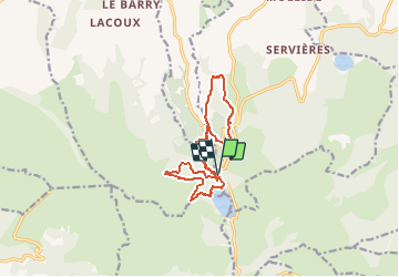
6.6 km | 9.5 km-effort
2h 9min
Yes
Trail Walking Orcival - Servieres_Vallee_Sioulot - Photo
Walking
GUIDE
jagarnier

Walking

Medium
(1)
Orcival, Auvergne-Rhône-Alpes, Puy-de-Dôme, France
11.7 km | 16.3 km-effort
3h 30min
Yes
Trail Walking Mont-Dore - Le puy de la tache, le lacs servières et guèry par la cascade du Queureuilh depuis l'Escalidou.  - Photo
Walking
loloetienne

Walking

Difficult
(3)
Mont-Dore, Auvergne-Rhône-Alpes, Puy-de-Dôme, France
34 km | 50 km-effort
10h 16min
Yes
Trail Walking Perpezat - Le lac de Guéry - Photo
Walking
tracegps

Walking

Difficult
(2)
Perpezat, Auvergne-Rhône-Alpes, Puy-de-Dôme, France
15 km | 22 km-effort
4h 0min
Yes
Trail Walking Chambon-sur-Lac - Puy de l'Angle 2740m 11.5.24 - Photo
Walking
GUIDE
fredetpascale

Walking

Medium
Chambon-sur-Lac, Auvergne-Rhône-Alpes, Puy-de-Dôme, France
7.8 km | 15.2 km-effort
2h 30min
Yes
Trail On foot Mont-Dore - Le Puy Gros - Photo
On foot
GUIDE+

On foot

Easy
(1)
Mont-Dore, Auvergne-Rhône-Alpes, Puy-de-Dôme, France
8.1 km | 13.7 km-effort
3h 6min
Yes
Trail On foot Murat-le-Quaire - La Banne d'Ordanche - Photo
On foot
GUIDE+

On foot

Easy
Murat-le-Quaire, Auvergne-Rhône-Alpes, Puy-de-Dôme, France
8.2 km | 13.9 km-effort
3h 9min
Yes
Trail On foot Mont-Dore - Le plateau du Guery - Photo
On foot
GUIDE+

On foot

Easy
Mont-Dore, Auvergne-Rhône-Alpes, Puy-de-Dôme, France
12.2 km | 18.4 km-effort
4h 11min
No
Trail On foot Mont-Dore - Les Cascades - Photo
On foot
GUIDE+

On foot

Medium
Mont-Dore, Auvergne-Rhône-Alpes, Puy-de-Dôme, France
15.7 km | 27 km-effort
6h 8min
Yes


Close
My subscriptions