![](/images/other/stat-length.png)
![Trail Running Azzana - Tour du Monté Cervellu - Photo](https://media.geolcdn.com/t/1900/400/ext.pjpeg?maxdim=2&url=https%3A%2F%2Fservices.sitytrail.com%2FGeolivesWS%2FDownloadMedia.ashx%3FTrailID%3D267365%26Media%3Dfix__20140416112729.jpg)
Tour du Monté Cervellu
Bruno.febvre
User
![Length](/images/other/stat-length.png)
![Max alt](https://static1.geolcdn.com/siteimages/upload/files/1508320355ic_sort_altitude_max_24dp.png)
![Uphill gradient](https://static1.geolcdn.com/siteimages/upload/files/1508320355ic_sort_den_pos_24dp.png)
![Km-Effort](/images/other/stat-length.png)
![Min alt](https://static1.geolcdn.com/siteimages/upload/files/1508320355ic_sort_altitude_min_24dp.png)
![Downhill gradient](https://static1.geolcdn.com/siteimages/upload/files/1508320355ic_sort_den_neg_24dp.png)
![Boucle](https://static1.geolcdn.com/siteimages/upload/files/16400158638029165_repeat_loop_refresh_sync_direction_icon.png)
![Running](https://static1.geolcdn.com/sitytour/trail-icons/103.png)
6h03
Difficulty : Very difficult
![Scan this QR Code to open this trail in the SityTrail application](https://capi.geolives.com/qq0zvz2zws4bq2lad0pu/sitytour/trails/267365/qr.png?size=200)
FREE GPS app for hiking
About
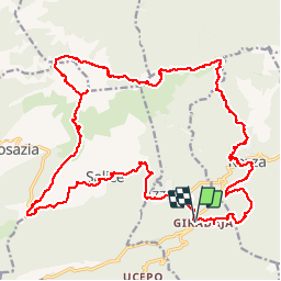
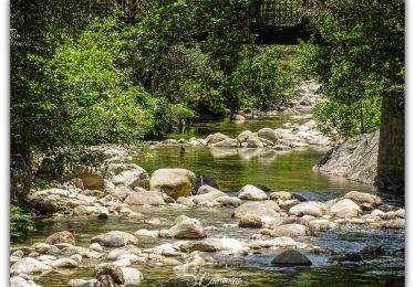
Trail Running of 30 km to be discovered at Corsica, South Corsica, Azzana. This trail is proposed by Bruno.febvre.
Description
Si vous aimez faire le sanglier, et vous frayer un passage dans la verte ce parcours est pour vous. Jusqu'à Bocca di Campu d'Occhiu tout se déroule bien. Ensuite les difficultés commencent ... Tout d'abord pour contourner le Mont Tretorre ensuite en versant nord du Cervellu. En effet le marquage est rare (orange) et le sentier souvent inexistant. Il faut être bien vigilant et repérer les anciens murets du sentier. La remontée sur le Monte Cervellu ne pose aucun problème. Par contre la descente en crête plein sud est une aventure. On cherche très souvent le sentier !!! J'étais en plein brouillard ... Ceci explique peut être mes galères. Retour par la route car je n'ai pas trouvé la variante Macchione. Sinon un beau parcours d'entrainement mais l'ensemble reste peu roulant ... Vous ne battrez pas votre record de vitesse ...
Positioning
Comments
Trails nearby
![Trail Walking Rosazia - Monte Cervellu - Photo](https://media.geolcdn.com/t/375/260/b300dc97-9263-4f72-ac85-116880e29142.jpg&format=jpg&maxdim=2)
![Walking Walking](https://static1.geolcdn.com/sitytour/trail-icons/101.png)
Walking
![](/images/other/stat-length.png)
![](https://static1.geolcdn.com/siteimages/upload/files/16400158638029165_repeat_loop_refresh_sync_direction_icon.png)
![Trail Walking Salice - bocca di tartavellu st eliseu sarrula - Photo](https://media.geolcdn.com/t/375/260/56b60591-e6b4-42ed-9e8f-b27f016988e6.jpg&format=jpg&maxdim=2)
![Walking Walking](https://static1.geolcdn.com/sitytour/trail-icons/101.png)
Walking
![](/images/other/stat-length.png)
![](https://static1.geolcdn.com/siteimages/upload/files/16400158638029165_repeat_loop_refresh_sync_direction_icon.png)
![Trail Walking Azzana - cruzzini - Photo](https://media.geolcdn.com/t/375/260/44789842-532a-4648-81a1-18a3135715ca.jpg&format=jpg&maxdim=2)
![Walking Walking](https://static1.geolcdn.com/sitytour/trail-icons/101.png)
![Trail Walking Pastricciola - Mare a mare Nord Boucle centre - Etape 5 - Pastricciola - Guagno - Photo](https://media.geolcdn.com/t/375/260/ext.jpg?maxdim=2&url=https%3A%2F%2Fstatic1.geolcdn.com%2Fsiteimages%2Fupload%2Ffiles%2F1553511878bg_sport_marche.png)
![Walking Walking](https://static1.geolcdn.com/sitytour/trail-icons/101.png)
Walking
![](/images/other/stat-length.png)
![](https://static1.geolcdn.com/siteimages/upload/files/16400158638029165_repeat_loop_refresh_sync_direction_icon.png)
![Trail Walking Salice - Punta Sant'Eliseo - Photo](https://media.geolcdn.com/t/375/260/ext.jpg?maxdim=2&url=https%3A%2F%2Fstatic1.geolcdn.com%2Fsiteimages%2Fupload%2Ffiles%2F1553511878bg_sport_marche.png)
![Walking Walking](https://static1.geolcdn.com/sitytour/trail-icons/101.png)
Walking
![](/images/other/stat-length.png)
![](https://static1.geolcdn.com/siteimages/upload/files/16400158638029165_repeat_loop_refresh_sync_direction_icon.png)
![Trail Walking Salice - Punta Baricci A/R - Photo](https://media.geolcdn.com/t/375/260/ext.jpg?maxdim=2&url=https%3A%2F%2Fstatic1.geolcdn.com%2Fsiteimages%2Fupload%2Ffiles%2F1553511878bg_sport_marche.png)
![Walking Walking](https://static1.geolcdn.com/sitytour/trail-icons/101.png)
Walking
![](/images/other/stat-length.png)
![](https://static1.geolcdn.com/siteimages/upload/files/16400158638029165_repeat_loop_refresh_sync_direction_icon.png)
![Trail Walking Salice - 6 sept - Photo](https://media.geolcdn.com/t/375/260/ext.jpg?maxdim=2&url=https%3A%2F%2Fstatic1.geolcdn.com%2Fsiteimages%2Fupload%2Ffiles%2F1553511878bg_sport_marche.png)
![Walking Walking](https://static1.geolcdn.com/sitytour/trail-icons/101.png)
![Trail Car Guagno - piste tretorre - Photo](https://media.geolcdn.com/t/375/260/ext.jpg?maxdim=2&url=https%3A%2F%2Fstatic1.geolcdn.com%2Fsiteimages%2Fupload%2Ffiles%2F15247431544x4.jpg)
![Car Car](https://static1.geolcdn.com/sitytour/trail-icons/401.png)