![](/images/other/stat-length.png)
![Trail Walking Welkenraedt - Henri-Chapelle - Photo](https://media.geolcdn.com/t/1900/400/dbd0d890-28e1-4cee-b79e-4fe8d3420920.jpg&format=pjpeg&maxdim=2)
Henri-Chapelle
mumu.larandonneuse
User GUIDE
![Length](/images/other/stat-length.png)
Length
12.1 km
![Max alt](https://static1.geolcdn.com/siteimages/upload/files/1508320355ic_sort_altitude_max_24dp.png)
Max alt
353 m
![Uphill gradient](https://static1.geolcdn.com/siteimages/upload/files/1508320355ic_sort_den_pos_24dp.png)
Uphill gradient
207 m
![Km-Effort](/images/other/stat-length.png)
Km-Effort
14.9 km
![Min alt](https://static1.geolcdn.com/siteimages/upload/files/1508320355ic_sort_altitude_min_24dp.png)
Min alt
254 m
![Downhill gradient](https://static1.geolcdn.com/siteimages/upload/files/1508320355ic_sort_den_neg_24dp.png)
Downhill gradient
205 m
![Boucle](https://static1.geolcdn.com/siteimages/upload/files/16400158638029165_repeat_loop_refresh_sync_direction_icon.png)
Boucle
Yes
Creation date :
2021-02-11 12:51:06.205
Updated on :
2021-02-11 17:37:15.323
![Walking](https://static1.geolcdn.com/sitytour/trail-icons/101.png)
2h31
Difficulty : Easy
![Scan this QR Code to open this trail in the SityTrail application](https://capi.geolives.com/qq0zvz2zws4bq2lad0pu/sitytour/trails/2667646/qr.png?size=200)
FREE GPS app for hiking
About
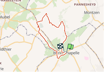
Trail Walking of 12.1 km to be discovered at Wallonia, Liège, Welkenraedt. This trail is proposed by mumu.larandonneuse.
Description
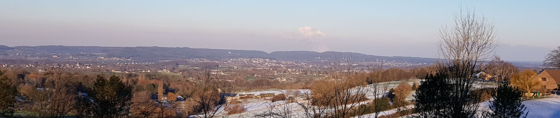
Très beau parcours balisé au départ d'Henri-Chapelle, village du Pays de Herve avec ses vues à 360° sur 3 vallées : vallée de la Vesdre, vallée de la Berwinne et vallée de la Gueule.
📌 Place du village
Positioning
Country:
Belgium
Region :
Wallonia
Department/Province :
Liège
Municipality :
Welkenraedt
Location:
Henri-Chapelle
Start:(Dec)
Start:(UTM)
707143 ; 5617960 (31U) N.
Comments
Trails nearby
![Trail Walking Thimister-Clermont - Froidthier - Photo](https://media.geolcdn.com/t/375/260/9142f7fe-feb5-4533-8005-65992f1c4338.jpg&format=jpg&maxdim=2)
![Walking Walking](https://static1.geolcdn.com/sitytour/trail-icons/101.png)
Froidthier
Walking
Easy
(1)
Thimister-Clermont,
Wallonia,
Liège,
Belgium
![](/images/other/stat-length.png)
6.6 km | 7.9 km-effort
1h 48min
![](https://static1.geolcdn.com/siteimages/upload/files/16400158638029165_repeat_loop_refresh_sync_direction_icon.png)
Yes
![Walking Walking](https://static1.geolcdn.com/sitytour/trail-icons/101.png)
20220428 - Bois de Hess 6.7 Km
Walking
Medium
(1)
Plombières,
Wallonia,
Liège,
Belgium
![](/images/other/stat-length.png)
6.7 km | 8.4 km-effort
3h 11min
![](https://static1.geolcdn.com/siteimages/upload/files/16400158638029165_repeat_loop_refresh_sync_direction_icon.png)
Yes
![Trail Walking Lontzen - 2021-05-03_18h55m44_herbesthal - Photo](https://media.geolcdn.com/t/375/260/f329bf39-b33b-4890-a8af-1e7d956ba015.jpg&format=jpg&maxdim=2)
![Walking Walking](https://static1.geolcdn.com/sitytour/trail-icons/101.png)
2021-05-03_18h55m44_herbesthal
Walking
Easy
(2)
Lontzen,
Wallonia,
Liège,
Belgium
![](/images/other/stat-length.png)
13.4 km | 15.8 km-effort
3h 35min
![](https://static1.geolcdn.com/siteimages/upload/files/16400158638029165_repeat_loop_refresh_sync_direction_icon.png)
Yes
![Trail Walking Aubel - RB-Lg-04 - Raccourci - À travers le bocage aubelois - Photo](https://media.geolcdn.com/t/375/260/ext.jpg?maxdim=2&url=https%3A%2F%2Fservices.sitytrail.com%2FGeolivesWS%2FDownloadMedia.ashx%3FTrailID%3D209393%26Media%3D9ac6c0af-9a08-4948-b5d5-06a09e8ba132.jpg)
![Walking Walking](https://static1.geolcdn.com/sitytour/trail-icons/101.png)
RB-Lg-04 - Raccourci - À travers le bocage aubelois
Walking
Medium
(4)
Aubel,
Wallonia,
Liège,
Belgium
![](/images/other/stat-length.png)
17.1 km | 22 km-effort
4h 50min
![](https://static1.geolcdn.com/siteimages/upload/files/16400158638029165_repeat_loop_refresh_sync_direction_icon.png)
Yes
![Trail Walking Welkenraedt - Promenade des deux Châteaux (5km) - Photo](https://media.geolcdn.com/t/375/260/ext.jpg?maxdim=2&url=https%3A%2F%2Fstatic1.geolcdn.com%2Fsiteimages%2Fupload%2Ffiles%2F1553511878bg_sport_marche.png)
![Walking Walking](https://static1.geolcdn.com/sitytour/trail-icons/101.png)
Promenade des deux Châteaux (5km)
Walking
Very easy
(2)
Welkenraedt,
Wallonia,
Liège,
Belgium
![](/images/other/stat-length.png)
5.4 km | 6 km-effort
Unknown
![](https://static1.geolcdn.com/siteimages/upload/files/16400158638029165_repeat_loop_refresh_sync_direction_icon.png)
Yes
![Trail Walking Plombières - Promenade autour de Moresnet (7km) - Photo](https://media.geolcdn.com/t/375/260/ext.jpg?maxdim=2&url=https%3A%2F%2Fstatic1.geolcdn.com%2Fsiteimages%2Fupload%2Ffiles%2F1553511878bg_sport_marche.png)
![Walking Walking](https://static1.geolcdn.com/sitytour/trail-icons/101.png)
Promenade autour de Moresnet (7km)
Walking
Very easy
(1)
Plombières,
Wallonia,
Liège,
Belgium
![](/images/other/stat-length.png)
6.9 km | 8.7 km-effort
Unknown
![](https://static1.geolcdn.com/siteimages/upload/files/16400158638029165_repeat_loop_refresh_sync_direction_icon.png)
Yes
![Trail Walking Welkenraedt - Welkenraedt - Eupen gare à gare 24 km - Photo](https://media.geolcdn.com/t/375/260/e68d37f0-dd17-4776-8e5a-50b786d8e3bf.jpg&format=jpg&maxdim=2)
![Walking Walking](https://static1.geolcdn.com/sitytour/trail-icons/101.png)
Welkenraedt - Eupen gare à gare 24 km
Walking
Difficult
Welkenraedt,
Wallonia,
Liège,
Belgium
![](/images/other/stat-length.png)
25 km | 29 km-effort
6h 40min
![](https://static1.geolcdn.com/siteimages/upload/files/16400158638029165_repeat_loop_refresh_sync_direction_icon.png)
No
![Trail Walking Thimister-Clermont - 20240803 - TOTEMUS THIMISTER-CLERMONT - 6.5 Km - Photo](https://media.geolcdn.com/t/375/260/70a0f284-29e7-4259-9b30-c9307bf9a076.jpeg&format=jpg&maxdim=2)
![Walking Walking](https://static1.geolcdn.com/sitytour/trail-icons/101.png)
20240803 - TOTEMUS THIMISTER-CLERMONT - 6.5 Km
Walking
Medium
Thimister-Clermont,
Wallonia,
Liège,
Belgium
![](/images/other/stat-length.png)
6.6 km | 7.8 km-effort
1h 45min
![](https://static1.geolcdn.com/siteimages/upload/files/16400158638029165_repeat_loop_refresh_sync_direction_icon.png)
Yes
![Trail Walking Aubel - 20240707 - AUBEL La belle balade BelRTL - 6.5 Km - Photo](https://media.geolcdn.com/t/375/260/5e90ecb1-1ab6-4f36-8ef5-58cf1e535eda.jpeg&format=jpg&maxdim=2)
![Walking Walking](https://static1.geolcdn.com/sitytour/trail-icons/101.png)
20240707 - AUBEL La belle balade BelRTL - 6.5 Km
Walking
Medium
Aubel,
Wallonia,
Liège,
Belgium
![](/images/other/stat-length.png)
6.5 km | 7.8 km-effort
1h 46min
![](https://static1.geolcdn.com/siteimages/upload/files/16400158638029165_repeat_loop_refresh_sync_direction_icon.png)
Yes