![](/images/other/stat-length.png)
![Trail Walking Villejuif - Le tour de Villejuif - Photo](https://media.geolcdn.com/t/1900/400/89c68fa5-e218-427b-b741-ac8d8012970d.jpg&format=pjpeg&maxdim=2)
Le tour de Villejuif
c.chehere
User
![Length](/images/other/stat-length.png)
Length
13.2 km
![Max alt](https://static1.geolcdn.com/siteimages/upload/files/1508320355ic_sort_altitude_max_24dp.png)
Max alt
136 m
![Uphill gradient](https://static1.geolcdn.com/siteimages/upload/files/1508320355ic_sort_den_pos_24dp.png)
Uphill gradient
139 m
![Km-Effort](/images/other/stat-length.png)
Km-Effort
15.1 km
![Min alt](https://static1.geolcdn.com/siteimages/upload/files/1508320355ic_sort_altitude_min_24dp.png)
Min alt
64 m
![Downhill gradient](https://static1.geolcdn.com/siteimages/upload/files/1508320355ic_sort_den_neg_24dp.png)
Downhill gradient
144 m
![Boucle](https://static1.geolcdn.com/siteimages/upload/files/16400158638029165_repeat_loop_refresh_sync_direction_icon.png)
Boucle
Yes
Creation date :
2021-02-09 09:01:47.996
Updated on :
2021-02-09 13:21:12.086
![Walking](https://static1.geolcdn.com/sitytour/trail-icons/101.png)
3h32
Difficulty : Very easy
![Scan this QR Code to open this trail in the SityTrail application](https://capi.geolives.com/qq0zvz2zws4bq2lad0pu/sitytour/trails/2665411/qr.png?size=200)
FREE GPS app for hiking
About
Trail Walking of 13.2 km to be discovered at Ile-de-France, Val-de-Marne, Villejuif. This trail is proposed by c.chehere.
Description
Des inégalités, des passages intéressants et des longueurs.
Balisage très irrégulier, des manques sur de grandes longueurs.
Perso, j'ai utilisé les transports. Le bus 162 arrêt" IGR"
Positioning
Country:
France
Region :
Ile-de-France
Department/Province :
Val-de-Marne
Municipality :
Villejuif
Location:
Unknown
Start:(Dec)
Start:(UTM)
452273 ; 5405088 (31U) N.
Comments
Trails nearby
![Trail Walking Paris - Balade Paris Mars - Street art 13 ème / Tours Novel / Mouffetard---> Montorgueil - Photo](https://media.geolcdn.com/t/375/260/f8997d8c-ff6a-4865-a3fa-0c8ffc9300f3.jpg&format=jpg&maxdim=2)
![Walking Walking](https://static1.geolcdn.com/sitytour/trail-icons/101.png)
Balade Paris Mars - Street art 13 ème / Tours Novel / Mouffetard---> Montorgueil
Walking
Very easy
(1)
Paris,
Ile-de-France,
Paris,
France
![](/images/other/stat-length.png)
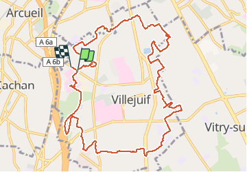
18.4 km | 22 km-effort
6h 21min
![](https://static1.geolcdn.com/siteimages/upload/files/16400158638029165_repeat_loop_refresh_sync_direction_icon.png)
No
![Trail Walking Paris - Balade parisienne le 28 février - Photo](https://media.geolcdn.com/t/375/260/68aea2de-42ab-49c3-94e6-4fbf1fbdd020.jpg&format=jpg&maxdim=2)
![Walking Walking](https://static1.geolcdn.com/sitytour/trail-icons/101.png)
Balade parisienne le 28 février
Walking
Very easy
(1)
Paris,
Ile-de-France,
Paris,
France
![](/images/other/stat-length.png)
23 km | 27 km-effort
5h 39min
![](https://static1.geolcdn.com/siteimages/upload/files/16400158638029165_repeat_loop_refresh_sync_direction_icon.png)
No
![Trail Walking Paris - DP75-16 De Chevaleret à Tolbiac - Photo](https://media.geolcdn.com/t/375/260/8a47c3b6-24b3-49fa-a2b6-5293a39f948c.jpg&format=jpg&maxdim=2)
![Walking Walking](https://static1.geolcdn.com/sitytour/trail-icons/101.png)
DP75-16 De Chevaleret à Tolbiac
Walking
Easy
(1)
Paris,
Ile-de-France,
Paris,
France
![](/images/other/stat-length.png)
4.3 km | 5.1 km-effort
1h 8min
![](https://static1.geolcdn.com/siteimages/upload/files/16400158638029165_repeat_loop_refresh_sync_direction_icon.png)
No
![Trail Walking Paris - DP75-15 Du square Saint-Médard à Chevaleret - Photo](https://media.geolcdn.com/t/375/260/78e272bf-5c47-4ff2-b6dd-62e8326c2885.jpg&format=jpg&maxdim=2)
![Walking Walking](https://static1.geolcdn.com/sitytour/trail-icons/101.png)
DP75-15 Du square Saint-Médard à Chevaleret
Walking
Easy
(1)
Paris,
Ile-de-France,
Paris,
France
![](/images/other/stat-length.png)
3.3 km | 4 km-effort
54min
![](https://static1.geolcdn.com/siteimages/upload/files/16400158638029165_repeat_loop_refresh_sync_direction_icon.png)
No
![Trail Walking Paris - DP75-13 De Vaugirard à Sèvres-Babylone - Photo](https://media.geolcdn.com/t/375/260/ef3b90ff-736f-49ef-8953-54f5a63f322a.jpg&format=jpg&maxdim=2)
![Walking Walking](https://static1.geolcdn.com/sitytour/trail-icons/101.png)
DP75-13 De Vaugirard à Sèvres-Babylone
Walking
Easy
(1)
Paris,
Ile-de-France,
Paris,
France
![](/images/other/stat-length.png)
4.4 km | 5 km-effort
1h 8min
![](https://static1.geolcdn.com/siteimages/upload/files/16400158638029165_repeat_loop_refresh_sync_direction_icon.png)
No
![Trail Walking Paris - De galerie en galerie : Expo Seth et Monsieur Chat + qques Invaders 840 points - Photo](https://media.geolcdn.com/t/375/260/89f2c5e9-9fd4-44df-a869-083c41cecb05.jpg&format=jpg&maxdim=2)
![Walking Walking](https://static1.geolcdn.com/sitytour/trail-icons/101.png)
De galerie en galerie : Expo Seth et Monsieur Chat + qques Invaders 840 points
Walking
Very easy
Paris,
Ile-de-France,
Paris,
France
![](/images/other/stat-length.png)
14.2 km | 16.5 km-effort
2h 48min
![](https://static1.geolcdn.com/siteimages/upload/files/16400158638029165_repeat_loop_refresh_sync_direction_icon.png)
No
![Trail On foot Paris - Space Invaders Place d'Italie Gare de Lyon 800 points - Photo](https://media.geolcdn.com/t/375/260/06c71c33-824e-4fda-b28a-91b79a42041a.jpg&format=jpg&maxdim=2)
![On foot On foot](https://static1.geolcdn.com/sitytour/trail-icons/100.png)
Space Invaders Place d'Italie Gare de Lyon 800 points
On foot
Easy
Paris,
Ile-de-France,
Paris,
France
![](/images/other/stat-length.png)
9.4 km | 10.7 km-effort
2h 26min
![](https://static1.geolcdn.com/siteimages/upload/files/16400158638029165_repeat_loop_refresh_sync_direction_icon.png)
No
![Trail Walking Paris - Chasse aux invaders du 13ème et balade street art - 1040 points - Photo](https://media.geolcdn.com/t/375/260/f4034ed0-89b2-4aca-85a5-05fcb7ea16f1.jpg&format=jpg&maxdim=2)
![Walking Walking](https://static1.geolcdn.com/sitytour/trail-icons/101.png)
Chasse aux invaders du 13ème et balade street art - 1040 points
Walking
Easy
Paris,
Ile-de-France,
Paris,
France
![](/images/other/stat-length.png)
17.2 km | 20 km-effort
3h 50min
![](https://static1.geolcdn.com/siteimages/upload/files/16400158638029165_repeat_loop_refresh_sync_direction_icon.png)
No
![Trail Walking Vitry-sur-Seine - Vitry Sur Seine Balade Street art - Photo](https://media.geolcdn.com/t/375/260/ca7972c4-c4f3-4fec-8ba6-636faaabe286.jpg&format=jpg&maxdim=2)
![Walking Walking](https://static1.geolcdn.com/sitytour/trail-icons/101.png)
Vitry Sur Seine Balade Street art
Walking
Easy
Vitry-sur-Seine,
Ile-de-France,
Val-de-Marne,
France
![](/images/other/stat-length.png)
3.3 km | 3.7 km-effort
1h 1min
![](https://static1.geolcdn.com/siteimages/upload/files/16400158638029165_repeat_loop_refresh_sync_direction_icon.png)
Yes