![](/images/other/stat-length.png)
![Trail Walking Tessenderlo - Averbode Bos en Heide 1 - Photo](https://media.geolcdn.com/t/1900/400/2cde0cd9-375f-4996-9768-b7a1d9d7074b.jpg&format=pjpeg&maxdim=2)
Averbode Bos en Heide 1
Bart.Bervoets
User
![Length](/images/other/stat-length.png)
Length
10.9 km
![Max alt](https://static1.geolcdn.com/siteimages/upload/files/1508320355ic_sort_altitude_max_24dp.png)
Max alt
51 m
![Uphill gradient](https://static1.geolcdn.com/siteimages/upload/files/1508320355ic_sort_den_pos_24dp.png)
Uphill gradient
136 m
![Km-Effort](/images/other/stat-length.png)
Km-Effort
12.7 km
![Min alt](https://static1.geolcdn.com/siteimages/upload/files/1508320355ic_sort_altitude_min_24dp.png)
Min alt
19 m
![Downhill gradient](https://static1.geolcdn.com/siteimages/upload/files/1508320355ic_sort_den_neg_24dp.png)
Downhill gradient
134 m
![Boucle](https://static1.geolcdn.com/siteimages/upload/files/16400158638029165_repeat_loop_refresh_sync_direction_icon.png)
Boucle
Yes
Creation date :
2021-02-08 20:26:02.259
Updated on :
2021-02-08 22:19:09.36
![Walking](https://static1.geolcdn.com/sitytour/trail-icons/101.png)
2h30
Difficulty : Easy
![Scan this QR Code to open this trail in the SityTrail application](https://capi.geolives.com/qq0zvz2zws4bq2lad0pu/sitytour/trails/2665103/qr.png?size=200)
FREE GPS app for hiking
About
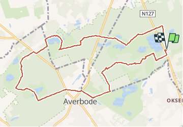
Trail Walking of 10.9 km to be discovered at Flanders, Limburg, Tessenderlo. This trail is proposed by Bart.Bervoets.
Description
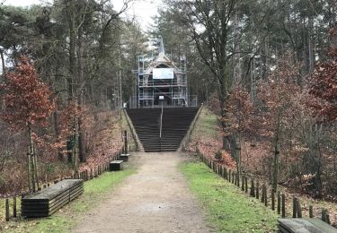
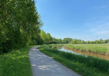
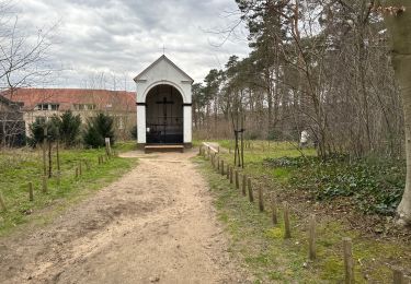
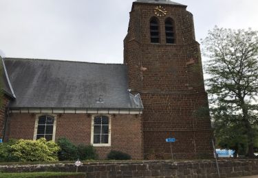
Sneeuwwandeling in Bos -en Heidegebied. Langs meerdere vennen en de abdij van Averbode.
Vertrek en aankomst : parking langs grote baan tussen Veerle en Okselaar.
Positioning
Country:
Belgium
Region :
Flanders
Department/Province :
Limburg
Municipality :
Tessenderlo
Location:
Tessenderlo
Start:(Dec)
Start:(UTM)
640841 ; 5656320 (31U) N.
Comments
Trails nearby
![Trail On foot Scherpenheuvel-Zichem - Demerbroeken Oranje bol - Photo](https://media.geolcdn.com/t/375/260/775e052a-ce6f-4462-9c7b-4e4daa1fa011.jpeg&format=jpg&maxdim=2)
![On foot On foot](https://static1.geolcdn.com/sitytour/trail-icons/100.png)
Demerbroeken Oranje bol
On foot
Easy
Scherpenheuvel-Zichem,
Flanders,
Flemish Brabant,
Belgium
![](/images/other/stat-length.png)
5.8 km | 6.4 km-effort
1h 27min
![](https://static1.geolcdn.com/siteimages/upload/files/16400158638029165_repeat_loop_refresh_sync_direction_icon.png)
Yes
![Trail On foot Tessenderlo - Asdonk Blauwe ruit - Photo](https://media.geolcdn.com/t/375/260/c599fae6-000e-4f9b-be4f-f8004ced1ebf.jpeg&format=jpg&maxdim=2)
![On foot On foot](https://static1.geolcdn.com/sitytour/trail-icons/100.png)
Asdonk Blauwe ruit
On foot
Easy
Tessenderlo,
Flanders,
Limburg,
Belgium
![](/images/other/stat-length.png)
4.3 km | 4.9 km-effort
1h 7min
![](https://static1.geolcdn.com/siteimages/upload/files/16400158638029165_repeat_loop_refresh_sync_direction_icon.png)
Yes
![Trail On foot Scherpenheuvel-Zichem - Demerbroeken Rode driehoek - Photo](https://media.geolcdn.com/t/375/260/b8ba7ae9-c0ac-4a35-8696-65f6c1b52038.jpeg&format=jpg&maxdim=2)
![On foot On foot](https://static1.geolcdn.com/sitytour/trail-icons/100.png)
Demerbroeken Rode driehoek
On foot
Easy
Scherpenheuvel-Zichem,
Flanders,
Flemish Brabant,
Belgium
![](/images/other/stat-length.png)
8.9 km | 10 km-effort
2h 16min
![](https://static1.geolcdn.com/siteimages/upload/files/16400158638029165_repeat_loop_refresh_sync_direction_icon.png)
Yes
![Trail On foot Tessenderlo - Asdonk Rode driehoek - Photo](https://media.geolcdn.com/t/375/260/c599fae6-000e-4f9b-be4f-f8004ced1ebf.jpeg&format=jpg&maxdim=2)
![On foot On foot](https://static1.geolcdn.com/sitytour/trail-icons/100.png)
Asdonk Rode driehoek
On foot
Easy
Tessenderlo,
Flanders,
Limburg,
Belgium
![](/images/other/stat-length.png)
8.6 km | 9.9 km-effort
2h 14min
![](https://static1.geolcdn.com/siteimages/upload/files/16400158638029165_repeat_loop_refresh_sync_direction_icon.png)
Yes
![Trail Walking Scherpenheuvel-Zichem - averbode 16,5 km - Photo](https://media.geolcdn.com/t/375/260/ext.jpg?maxdim=2&url=https%3A%2F%2Fservices.sitytrail.com%2FGeolivesWS%2FDownloadMedia.ashx%3FTrailID%3D1108116%26Media%3D20190209143100.jpg)
![Walking Walking](https://static1.geolcdn.com/sitytour/trail-icons/101.png)
averbode 16,5 km
Walking
Very easy
Scherpenheuvel-Zichem,
Flanders,
Flemish Brabant,
Belgium
![](/images/other/stat-length.png)
17.1 km | 19.6 km-effort
4h 15min
![](https://static1.geolcdn.com/siteimages/upload/files/16400158638029165_repeat_loop_refresh_sync_direction_icon.png)
Yes
![Trail Walking Scherpenheuvel-Zichem - S-GR Hageland : Testelt - Aarschot - Photo](https://media.geolcdn.com/t/375/260/4bbf69b0-9fae-4ef2-92ae-aca7d00c64c3.jpeg&format=jpg&maxdim=2)
![Walking Walking](https://static1.geolcdn.com/sitytour/trail-icons/101.png)
S-GR Hageland : Testelt - Aarschot
Walking
Medium
Scherpenheuvel-Zichem,
Flanders,
Flemish Brabant,
Belgium
![](/images/other/stat-length.png)
17.8 km | 20 km-effort
4h 37min
![](https://static1.geolcdn.com/siteimages/upload/files/16400158638029165_repeat_loop_refresh_sync_direction_icon.png)
No
![Trail Walking Scherpenheuvel-Zichem - Averbode Hertberg 17,1 km - Photo](https://media.geolcdn.com/t/375/260/523f3a4f-54f4-42d3-bdf4-8699c3a9b38a.jpg&format=jpg&maxdim=2)
![Walking Walking](https://static1.geolcdn.com/sitytour/trail-icons/101.png)
Averbode Hertberg 17,1 km
Walking
Medium
Scherpenheuvel-Zichem,
Flanders,
Flemish Brabant,
Belgium
![](/images/other/stat-length.png)
17.1 km | 19.7 km-effort
4h 52min
![](https://static1.geolcdn.com/siteimages/upload/files/16400158638029165_repeat_loop_refresh_sync_direction_icon.png)
Yes
![Trail On foot Scherpenheuvel-Zichem - Demerbroeken Blauwe ruit - Photo](https://media.geolcdn.com/t/375/260/8dda6c78-a391-4423-b3b3-92d225b48824.jpeg&format=jpg&maxdim=2)
![On foot On foot](https://static1.geolcdn.com/sitytour/trail-icons/100.png)
Demerbroeken Blauwe ruit
On foot
Easy
Scherpenheuvel-Zichem,
Flanders,
Flemish Brabant,
Belgium
![](/images/other/stat-length.png)
3.6 km | 4.2 km-effort
57min
![](https://static1.geolcdn.com/siteimages/upload/files/16400158638029165_repeat_loop_refresh_sync_direction_icon.png)
Yes
![Trail Walking Scherpenheuvel-Zichem - Testelt Averbode 24 km - Photo](https://media.geolcdn.com/t/375/260/ext.jpg?maxdim=2&url=https%3A%2F%2Fservices.sitytrail.com%2FGeolivesWS%2FDownloadMedia.ashx%3FTrailID%3D1036218%26Media%3D20180908155010.jpg)
![Walking Walking](https://static1.geolcdn.com/sitytour/trail-icons/101.png)
Testelt Averbode 24 km
Walking
Easy
Scherpenheuvel-Zichem,
Flanders,
Flemish Brabant,
Belgium
![](/images/other/stat-length.png)
25 km | 28 km-effort
5h 40min
![](https://static1.geolcdn.com/siteimages/upload/files/16400158638029165_repeat_loop_refresh_sync_direction_icon.png)
Yes