![](/images/other/stat-length.png)
![Trail On foot Serres-Morlaàs - 2021-02-08_18h29m06_M2-Serres-Morlaas 8 km - Photo](https://media.geolcdn.com/t/1900/400/ext.pjpeg?maxdim=2&url=https%3A%2F%2Fstatic1.geolcdn.com%2Fsiteimages%2Fupload%2Ffiles%2F1545311037marcheuse_200dpi.jpg)
2021-02-08_18h29m06_M2-Serres-Morlaas 8 km
mitch1952
User
![Length](/images/other/stat-length.png)
Length
8.1 km
![Max alt](https://static1.geolcdn.com/siteimages/upload/files/1508320355ic_sort_altitude_max_24dp.png)
Max alt
327 m
![Uphill gradient](https://static1.geolcdn.com/siteimages/upload/files/1508320355ic_sort_den_pos_24dp.png)
Uphill gradient
108 m
![Km-Effort](/images/other/stat-length.png)
Km-Effort
9.6 km
![Min alt](https://static1.geolcdn.com/siteimages/upload/files/1508320355ic_sort_altitude_min_24dp.png)
Min alt
246 m
![Downhill gradient](https://static1.geolcdn.com/siteimages/upload/files/1508320355ic_sort_den_neg_24dp.png)
Downhill gradient
107 m
![Boucle](https://static1.geolcdn.com/siteimages/upload/files/16400158638029165_repeat_loop_refresh_sync_direction_icon.png)
Boucle
Yes
Creation date :
2021-02-08 17:29:06.192
Updated on :
2022-06-07 13:59:28.857
![On foot](https://static1.geolcdn.com/sitytour/trail-icons/100.png)
2h10
Difficulty : Easy
![Scan this QR Code to open this trail in the SityTrail application](https://capi.geolives.com/qq0zvz2zws4bq2lad0pu/sitytour/trails/2664957/qr.png?size=200)
FREE GPS app for hiking
About
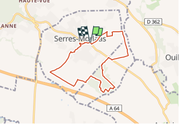
Trail On foot of 8.1 km to be discovered at New Aquitaine, Pyrénées-Atlantiques, Serres-Morlaàs. This trail is proposed by mitch1952.
Description
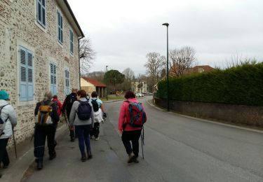
Très facile mais qqs flaques d'eau même par beau temps.
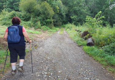
Pour le retour emprunter un chemin en herbe, qui montent entre les villas et où on découvre un jardin plein de sculptures en fer.
Positioning
Country:
France
Region :
New Aquitaine
Department/Province :
Pyrénées-Atlantiques
Municipality :
Serres-Morlaàs
Location:
Unknown
Start:(Dec)
Start:(UTM)
722479 ; 4800576 (30T) N.
Comments
Trails nearby
![Trail Walking Idron - Idron golf - Photo](https://media.geolcdn.com/t/375/260/ext.jpg?maxdim=2&url=https%3A%2F%2Fstatic1.geolcdn.com%2Fsiteimages%2Fupload%2Ffiles%2F1553511878bg_sport_marche.png)
![Walking Walking](https://static1.geolcdn.com/sitytour/trail-icons/101.png)
Idron golf
Walking
Very easy
(1)
Idron,
New Aquitaine,
Pyrénées-Atlantiques,
France
![](/images/other/stat-length.png)
3.3 km | 3.6 km-effort
48min
![](https://static1.geolcdn.com/siteimages/upload/files/16400158638029165_repeat_loop_refresh_sync_direction_icon.png)
Yes
![Trail sport Ouillon - MNS Ouillon - Photo](https://media.geolcdn.com/t/375/260/ext.jpg?maxdim=2&url=https%3A%2F%2Fsecurestorage.geolives.com%2Fsitytour%2Ftrail-bg%2Fdefault.jpg)
MNS Ouillon
sport
Very easy
(1)
Ouillon,
New Aquitaine,
Pyrénées-Atlantiques,
France
![](/images/other/stat-length.png)
4.9 km | 5.3 km-effort
Unknown
![](https://static1.geolcdn.com/siteimages/upload/files/16400158638029165_repeat_loop_refresh_sync_direction_icon.png)
Yes
![Trail On foot Saint-Jammes - BALISAGE GR653 A 2eme partie ABERE/ entrée de Morlaas /Pilar fait 2833880 - Photo](https://media.geolcdn.com/t/375/260/f993f3ce-6b4d-4b5a-bcb1-4f2620873f19.jpg&format=jpg&maxdim=2)
![On foot On foot](https://static1.geolcdn.com/sitytour/trail-icons/100.png)
BALISAGE GR653 A 2eme partie ABERE/ entrée de Morlaas /Pilar fait 2833880
On foot
Easy
Saint-Jammes,
New Aquitaine,
Pyrénées-Atlantiques,
France
![](/images/other/stat-length.png)
11.6 km | 13.8 km-effort
3h 5min
![](https://static1.geolcdn.com/siteimages/upload/files/16400158638029165_repeat_loop_refresh_sync_direction_icon.png)
No
![Trail Walking Idron - IDRON La Micheloise M2- - Photo](https://media.geolcdn.com/t/375/260/2bbf73de-0d3e-4644-8dda-998d80ada584.jpg&format=jpg&maxdim=2)
![Walking Walking](https://static1.geolcdn.com/sitytour/trail-icons/101.png)
IDRON La Micheloise M2-
Walking
Very easy
Idron,
New Aquitaine,
Pyrénées-Atlantiques,
France
![](/images/other/stat-length.png)
8.4 km | 9.8 km-effort
2h 20min
![](https://static1.geolcdn.com/siteimages/upload/files/16400158638029165_repeat_loop_refresh_sync_direction_icon.png)
Yes
![Trail Walking Serres-Morlaàs - SERRES MORLAAS-MNT-R - Photo](https://media.geolcdn.com/t/375/260/ext.jpg?maxdim=2&url=https%3A%2F%2Fstatic1.geolcdn.com%2Fsiteimages%2Fupload%2Ffiles%2F1553511878bg_sport_marche.png)
![Walking Walking](https://static1.geolcdn.com/sitytour/trail-icons/101.png)
SERRES MORLAAS-MNT-R
Walking
Easy
(1)
Serres-Morlaàs,
New Aquitaine,
Pyrénées-Atlantiques,
France
![](/images/other/stat-length.png)
4.6 km | 5.8 km-effort
1h 15min
![](https://static1.geolcdn.com/siteimages/upload/files/16400158638029165_repeat_loop_refresh_sync_direction_icon.png)
Yes
![Trail Walking Idron - IDRON avec Loulou sans palmes ni tuba - Photo](https://media.geolcdn.com/t/375/260/233f0820-9a44-4141-a58a-9a0c46ddcb62.jpg&format=jpg&maxdim=2)
![Walking Walking](https://static1.geolcdn.com/sitytour/trail-icons/101.png)
IDRON avec Loulou sans palmes ni tuba
Walking
Easy
Idron,
New Aquitaine,
Pyrénées-Atlantiques,
France
![](/images/other/stat-length.png)
3.4 km | 3.7 km-effort
58min
![](https://static1.geolcdn.com/siteimages/upload/files/16400158638029165_repeat_loop_refresh_sync_direction_icon.png)
Yes
![Trail Walking Morlaàs - MORLAAS du LEP au luy - Photo](https://media.geolcdn.com/t/375/260/35e40e20-bb5d-45a4-84e4-8d8455e72b82.jpg&format=jpg&maxdim=2)
![Walking Walking](https://static1.geolcdn.com/sitytour/trail-icons/101.png)
MORLAAS du LEP au luy
Walking
Medium
Morlaàs,
New Aquitaine,
Pyrénées-Atlantiques,
France
![](/images/other/stat-length.png)
9 km | 11.6 km-effort
2h 38min
![](https://static1.geolcdn.com/siteimages/upload/files/16400158638029165_repeat_loop_refresh_sync_direction_icon.png)
Yes
![Trail Walking Morlaàs - GR653. A 2eme partie faite le 3/06/2022 - Photo](https://media.geolcdn.com/t/375/260/f5cbd3c1-303d-4ec7-98c9-dde5d8d19849.jpg&format=jpg&maxdim=2)
![Walking Walking](https://static1.geolcdn.com/sitytour/trail-icons/101.png)
GR653. A 2eme partie faite le 3/06/2022
Walking
Medium
Morlaàs,
New Aquitaine,
Pyrénées-Atlantiques,
France
![](/images/other/stat-length.png)
6.5 km | 7 km-effort
2h 11min
![](https://static1.geolcdn.com/siteimages/upload/files/16400158638029165_repeat_loop_refresh_sync_direction_icon.png)
No
![Trail Walking Idron - IDRON avec un I comme inedit - Photo](https://media.geolcdn.com/t/375/260/10593ebb-10b7-406d-9321-e7633b60e9af.jpg&format=jpg&maxdim=2)
![Walking Walking](https://static1.geolcdn.com/sitytour/trail-icons/101.png)
IDRON avec un I comme inedit
Walking
Medium
Idron,
New Aquitaine,
Pyrénées-Atlantiques,
France
![](/images/other/stat-length.png)
8.9 km | 10.4 km-effort
2h 6min
![](https://static1.geolcdn.com/siteimages/upload/files/16400158638029165_repeat_loop_refresh_sync_direction_icon.png)
Yes