Trail Walking Bièvres - Petit tour de Bièvre - Photo

Petit tour de Bièvre

© OpenStreetMap contributors
Length
Length
13 km
Max alt
Max alt
178 m
Uphill gradient
Uphill gradient
240 m
Km-Effort
Km-Effort  
16 km
Min alt
Min alt
74 m
Downhill gradient
Downhill gradient
172 m
Boucle
Boucle
No
Creation date :
2021-02-07 13:36:17.054
Updated on :
2021-02-07 15:40:20.913

(0 Reviews)

Walking
Walking
2h00
Difficulty : Easy

Scan this QR Code to open this trail in the SityTrail application

FREE GPS app for hiking

Logo SityTrail SityTrail

IGN / Geographical institutes

Download SityTrail from the App Store Download SityTrail from Google Play

Logo SityTrail SityTrail World

The world is yours!

Download SityTrail from the App Store Download SityTrail from Google Play Download SityTrail on Huawei AppGallery

About

Trail Walking of 13 km to be discovered at Ile-de-France, Essonne, Bièvres. This trail is proposed by Sarah92130.

Description

Randonnée très variée sur un petit périmètre : forêt, rivière, monuments, vue sur la vallée de la Bièvre, étangs. La difficulté (une bonne côte) est concentrée au départ de la ballade. Bon à savoir :deux boulangeries ouvertes le dimanche après-midi midi près du parking pour le goûter des enfants (ou des grands ;-))

Elevation profile

Positioning

Country:
France
Region :
Ile-de-France
Department/Province :
Essonne
Municipality :
Bièvres
Location:
Unknown
Start:(UTM)
442243 ; 5400522 (31U) N.

Trails nearby

Trail Walking Jouy-en-Josas - GRP CV-IDF 2023 - Photo
Walking
clalaur

Walking

Difficult
(1)
Jouy-en-Josas, Ile-de-France, Yvelines, France
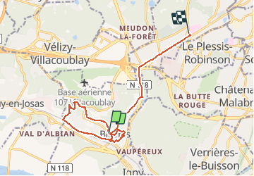
11.2 km | 14.5 km-effort
3h 17min
No
Trail Walking Bièvres - De Bièvres à Antony - Photo
Walking
tracegps

Walking

Medium
(1)
Bièvres, Ile-de-France, Essonne, France
11.9 km | 14 km-effort
3h 0min
No
Trail Walking Jouy-en-Josas - ferme viltain - Photo
Walking
papoune69

Walking

Very easy
(2)
Jouy-en-Josas, Ile-de-France, Yvelines, France
9 km | 10.1 km-effort
2h 13min
Yes
Trail Walking Verrières-le-Buisson - Sur les sentiers de découverte du Bois de Verrières - Photo
Walking
tracegps

Walking

Medium
(2)
Verrières-le-Buisson, Ile-de-France, Essonne, France
22 km | 27 km-effort
4h 40min
Yes
Trail Walking Sceaux - Les Hauts de Bièvre - Photo
Walking
tracegps

Walking

Difficult
(2)
Sceaux, Ile-de-France, Hauts-de-Seine, France
25 km | 30 km-effort
6h 0min
Yes
Trail Walking Bièvres - Autour de Bièvres - Photo
Walking
tracegps

Walking

Medium
(4)
Bièvres, Ile-de-France, Essonne, France
7.6 km | 9.4 km-effort
2h 30min
Yes
Trail Walking Clamart - Tour des etangs - Bois de Clamart et de Meudon - Photo
Walking
GUIDE
affinetataille

Walking

Easy
Clamart, Ile-de-France, Hauts-de-Seine, France
8 km | 9.9 km-effort
2h 16min
Yes
Trail Walking Vélizy-Villacoublay - Les forêts de Meudon et Versailles  - Photo
Walking
c.chehere

Walking

Easy
Vélizy-Villacoublay, Ile-de-France, Yvelines, France
14.5 km | 17.2 km-effort
3h 50min
Yes
Trail Walking Palaiseau - La Troche - Photo
Walking
c.chehere

Walking

Very difficult
Palaiseau, Ile-de-France, Essonne, France
16.5 km | 20 km-effort
4h 33min
No


Close
My subscriptions