![](/images/other/stat-length.png)
![Trail Walking Saint-Paul-de-Fenouillet - st Paul de fenouinlet / col lenty et retour - Photo](https://media.geolcdn.com/t/1900/400/281156ab-3036-4fe8-93da-4a2eaadc40df.jpg&format=pjpeg&maxdim=2)
st Paul de fenouinlet / col lenty et retour
Erius
User
![Length](/images/other/stat-length.png)
Length
9.6 km
![Max alt](https://static1.geolcdn.com/siteimages/upload/files/1508320355ic_sort_altitude_max_24dp.png)
Max alt
724 m
![Uphill gradient](https://static1.geolcdn.com/siteimages/upload/files/1508320355ic_sort_den_pos_24dp.png)
Uphill gradient
450 m
![Km-Effort](/images/other/stat-length.png)
Km-Effort
15.6 km
![Min alt](https://static1.geolcdn.com/siteimages/upload/files/1508320355ic_sort_altitude_min_24dp.png)
Min alt
278 m
![Downhill gradient](https://static1.geolcdn.com/siteimages/upload/files/1508320355ic_sort_den_neg_24dp.png)
Downhill gradient
452 m
![Boucle](https://static1.geolcdn.com/siteimages/upload/files/16400158638029165_repeat_loop_refresh_sync_direction_icon.png)
Boucle
Yes
Creation date :
2021-02-07 09:34:57.067
Updated on :
2021-02-07 14:48:38.782
![Walking](https://static1.geolcdn.com/sitytour/trail-icons/101.png)
2h59
Difficulty : Difficult
![Scan this QR Code to open this trail in the SityTrail application](https://capi.geolives.com/qq0zvz2zws4bq2lad0pu/sitytour/trails/2663476/qr.png?size=200)
FREE GPS app for hiking
About
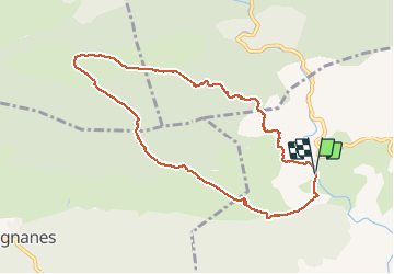
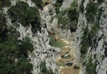
Trail Walking of 9.6 km to be discovered at Occitania, Pyrénées-Orientales, Saint-Paul-de-Fenouillet. This trail is proposed by Erius.
Description
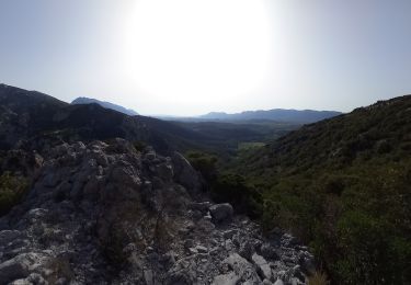
montee raide rochers sol glissant en cas de pluie récente.
forêt buis chêne
sur le plateau thym
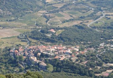
le retour est tranquille et domine la vallée vers foix
en ligne de mire st Paul et le canigou
Positioning
Country:
France
Region :
Occitania
Department/Province :
Pyrénées-Orientales
Municipality :
Saint-Paul-de-Fenouillet
Location:
Unknown
Start:(Dec)
Start:(UTM)
457528 ; 4742295 (31T) N.
Comments
Trails nearby
![Trail Walking Saint-Paul-de-Fenouillet - Ermitage de Galamus - Photo](https://media.geolcdn.com/t/375/260/46039162-6164-4640-a304-ccd455d5027d.jpg&format=jpg&maxdim=2)
![Walking Walking](https://static1.geolcdn.com/sitytour/trail-icons/101.png)
Ermitage de Galamus
Walking
Easy
Saint-Paul-de-Fenouillet,
Occitania,
Pyrénées-Orientales,
France
![](/images/other/stat-length.png)
1.3 km | 2.3 km-effort
26min
![](https://static1.geolcdn.com/siteimages/upload/files/16400158638029165_repeat_loop_refresh_sync_direction_icon.png)
Yes
![Trail Walking Saint-Paul-de-Fenouillet - La Quille - Photo](https://media.geolcdn.com/t/375/260/47f7336c-3219-4083-bfb3-c8b198d14d48.jpg&format=jpg&maxdim=2)
![Walking Walking](https://static1.geolcdn.com/sitytour/trail-icons/101.png)
La Quille
Walking
Very difficult
Saint-Paul-de-Fenouillet,
Occitania,
Pyrénées-Orientales,
France
![](/images/other/stat-length.png)
16.9 km | 29 km-effort
6h 23min
![](https://static1.geolcdn.com/siteimages/upload/files/16400158638029165_repeat_loop_refresh_sync_direction_icon.png)
No
![Trail Walking Saint-Paul-de-Fenouillet - Autour des gorges de Galamus - Photo](https://media.geolcdn.com/t/375/260/ebb1bc80-1a1f-4b07-90dd-5976415c2a9f.jpg&format=jpg&maxdim=2)
![Walking Walking](https://static1.geolcdn.com/sitytour/trail-icons/101.png)
Autour des gorges de Galamus
Walking
Very difficult
Saint-Paul-de-Fenouillet,
Occitania,
Pyrénées-Orientales,
France
![](/images/other/stat-length.png)
12.4 km | 22 km-effort
6h 28min
![](https://static1.geolcdn.com/siteimages/upload/files/16400158638029165_repeat_loop_refresh_sync_direction_icon.png)
Yes
![Trail Walking Prugnanes - roc paradet - Photo](https://media.geolcdn.com/t/375/260/f4e6fd12-f0ab-4601-9b76-44d15e72f3de.jpg&format=jpg&maxdim=2)
![Walking Walking](https://static1.geolcdn.com/sitytour/trail-icons/101.png)
roc paradet
Walking
Very difficult
Prugnanes,
Occitania,
Pyrénées-Orientales,
France
![](/images/other/stat-length.png)
11.3 km | 19.4 km-effort
5h 58min
![](https://static1.geolcdn.com/siteimages/upload/files/16400158638029165_repeat_loop_refresh_sync_direction_icon.png)
Yes
![Trail Walking Prugnanes - Prugnanes Roc Paradet - Photo](https://media.geolcdn.com/t/375/260/ext.jpg?maxdim=2&url=https%3A%2F%2Fservices.sitytrail.com%2FGeolivesWS%2FDownloadMedia.ashx%3FTrailID%3D327912%26Media%3Dfix__20140723095802.jpg)
![Walking Walking](https://static1.geolcdn.com/sitytour/trail-icons/101.png)
Prugnanes Roc Paradet
Walking
Medium
Prugnanes,
Occitania,
Pyrénées-Orientales,
France
![](/images/other/stat-length.png)
11.2 km | 19.4 km-effort
3h 56min
![](https://static1.geolcdn.com/siteimages/upload/files/16400158638029165_repeat_loop_refresh_sync_direction_icon.png)
Yes
![Trail Walking Saint-Paul-de-Fenouillet - Gorges galamus-Nissol_T - Photo](https://media.geolcdn.com/t/375/260/ext.jpg?maxdim=2&url=https%3A%2F%2Fservices.sitytrail.com%2FGeolivesWS%2FDownloadMedia.ashx%3FTrailID%3D306372%26Media%3Da7076bb5-3bf2-4c5a-a4d8-4346c03497ec.jpg)
![Walking Walking](https://static1.geolcdn.com/sitytour/trail-icons/101.png)
Gorges galamus-Nissol_T
Walking
Medium
Saint-Paul-de-Fenouillet,
Occitania,
Pyrénées-Orientales,
France
![](/images/other/stat-length.png)
13.8 km | 22 km-effort
4h 40min
![](https://static1.geolcdn.com/siteimages/upload/files/16400158638029165_repeat_loop_refresh_sync_direction_icon.png)
Yes
![Trail Walking Cubières-sur-Cinoble - Sentier Cathare - De Cubières à Duilhac sous Peyrepertuse - Photo](https://media.geolcdn.com/t/375/260/ext.jpg?maxdim=2&url=https%3A%2F%2Fservices.sitytrail.com%2FGeolivesWS%2FDownloadMedia.ashx%3FTrailID%3D106638%26Media%3D11248_6.jpg)
![Walking Walking](https://static1.geolcdn.com/sitytour/trail-icons/101.png)
Sentier Cathare - De Cubières à Duilhac sous Peyrepertuse
Walking
Difficult
Cubières-sur-Cinoble,
Occitania,
Aude,
France
![](/images/other/stat-length.png)
16.1 km | 23 km-effort
6h 30min
![](https://static1.geolcdn.com/siteimages/upload/files/16400158638029165_repeat_loop_refresh_sync_direction_icon.png)
No
![Trail Walking Camps-sur-l'Agly - Gorges de Galamus par Nissol - Photo](https://media.geolcdn.com/t/375/260/ext.jpg?maxdim=2&url=https%3A%2F%2Fservices.sitytrail.com%2FGeolivesWS%2FDownloadMedia.ashx%3FTrailID%3D103554%26Media%3D5803_6.jpg)
![Walking Walking](https://static1.geolcdn.com/sitytour/trail-icons/101.png)
Gorges de Galamus par Nissol
Walking
Difficult
(2)
Camps-sur-l'Agly,
Occitania,
Aude,
France
![](/images/other/stat-length.png)
14.9 km | 24 km-effort
5h 0min
![](https://static1.geolcdn.com/siteimages/upload/files/16400158638029165_repeat_loop_refresh_sync_direction_icon.png)
No
![Trail Walking Saint-Paul-de-Fenouillet - Gorges galamus - Photo](https://media.geolcdn.com/t/375/260/bcffc5c8-a228-45e3-afaa-dce84f23c131.jpg&format=jpg&maxdim=2)
![Walking Walking](https://static1.geolcdn.com/sitytour/trail-icons/101.png)
Gorges galamus
Walking
Saint-Paul-de-Fenouillet,
Occitania,
Pyrénées-Orientales,
France
![](/images/other/stat-length.png)
40 km | 84 km-effort
2h 54min
![](https://static1.geolcdn.com/siteimages/upload/files/16400158638029165_repeat_loop_refresh_sync_direction_icon.png)
No
thym