![](/images/other/stat-length.png)
![Trail Walking Les Moutiers-en-Retz - Polders de la Coupelasse et St-Cérans - Photo](https://media.geolcdn.com/t/1900/400/ext.pjpeg?maxdim=2&url=https%3A%2F%2Fstatic1.geolcdn.com%2Fsiteimages%2Fupload%2Ffiles%2F1553511878bg_sport_marche.png)
Polders de la Coupelasse et St-Cérans
neoroll44
User
![Length](/images/other/stat-length.png)
Length
8.8 km
![Max alt](https://static1.geolcdn.com/siteimages/upload/files/1508320355ic_sort_altitude_max_24dp.png)
Max alt
4 m
![Uphill gradient](https://static1.geolcdn.com/siteimages/upload/files/1508320355ic_sort_den_pos_24dp.png)
Uphill gradient
21 m
![Km-Effort](/images/other/stat-length.png)
Km-Effort
9 km
![Min alt](https://static1.geolcdn.com/siteimages/upload/files/1508320355ic_sort_altitude_min_24dp.png)
Min alt
-3 m
![Downhill gradient](https://static1.geolcdn.com/siteimages/upload/files/1508320355ic_sort_den_neg_24dp.png)
Downhill gradient
21 m
![Boucle](https://static1.geolcdn.com/siteimages/upload/files/16400158638029165_repeat_loop_refresh_sync_direction_icon.png)
Boucle
Yes
Creation date :
2021-02-06 20:54:05.862
Updated on :
2021-02-09 16:37:31.28
![Walking](https://static1.geolcdn.com/sitytour/trail-icons/101.png)
2h18
Difficulty : Medium
![Scan this QR Code to open this trail in the SityTrail application](https://capi.geolives.com/qq0zvz2zws4bq2lad0pu/sitytour/trails/2662804/qr.png?size=200)
FREE GPS app for hiking
About
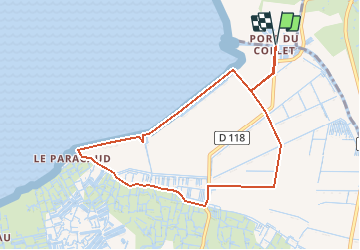
Trail Walking of 8.8 km to be discovered at Pays de la Loire, Loire-Atlantique, Les Moutiers-en-Retz. This trail is proposed by neoroll44.
Description
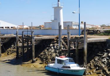
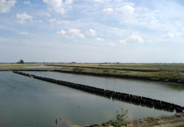
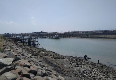
Depuis le port du Collet, suivre le GR et longer le polder de la Coupelasse.
Bifurquer à gauche vers la D118, puis tourner à droite et revenir par le polder de St Cérans.
Positioning
Country:
France
Region :
Pays de la Loire
Department/Province :
Loire-Atlantique
Municipality :
Les Moutiers-en-Retz
Location:
Unknown
Start:(Dec)
Start:(UTM)
577847 ; 5208913 (30T) N.
Comments
Trails nearby
![Trail Hybrid bike Bouin - Bouin-Boucle marais et digues - Photo](https://media.geolcdn.com/t/375/260/76a8df03-2986-44c5-9c04-b5c448f6a754.jpg&format=jpg&maxdim=2)
![Hybrid bike Hybrid bike](https://static1.geolcdn.com/sitytour/trail-icons/203.png)
Bouin-Boucle marais et digues
Hybrid bike
Very easy
Bouin,
Pays de la Loire,
Vendée,
France
![](/images/other/stat-length.png)
14.2 km | 14.6 km-effort
1h 29min
![](https://static1.geolcdn.com/siteimages/upload/files/16400158638029165_repeat_loop_refresh_sync_direction_icon.png)
Yes
![Trail On foot Villeneuve-en-Retz - PDIPR:1224 - Photo](https://media.geolcdn.com/t/375/260/1a57d417-9132-4bf4-870f-21ad0636d79e.jpeg&format=jpg&maxdim=2)
![On foot On foot](https://static1.geolcdn.com/sitytour/trail-icons/100.png)
PDIPR:1224
On foot
Easy
Villeneuve-en-Retz,
Pays de la Loire,
Loire-Atlantique,
France
![](/images/other/stat-length.png)
16.4 km | 17.8 km-effort
4h 2min
![](https://static1.geolcdn.com/siteimages/upload/files/16400158638029165_repeat_loop_refresh_sync_direction_icon.png)
No
![Trail On foot Bouin - Chemin des Oiseaux - Photo](https://media.geolcdn.com/t/375/260/afc4cdca-c735-43d5-92c0-996474eda780.jpeg&format=jpg&maxdim=2)
![On foot On foot](https://static1.geolcdn.com/sitytour/trail-icons/100.png)
Chemin des Oiseaux
On foot
Easy
Bouin,
Pays de la Loire,
Vendée,
France
![](/images/other/stat-length.png)
13.8 km | 14.2 km-effort
3h 13min
![](https://static1.geolcdn.com/siteimages/upload/files/16400158638029165_repeat_loop_refresh_sync_direction_icon.png)
No
![Trail On foot Les Moutiers-en-Retz - Le Collet - Photo](https://media.geolcdn.com/t/375/260/1a57d417-9132-4bf4-870f-21ad0636d79e.jpeg&format=jpg&maxdim=2)
![On foot On foot](https://static1.geolcdn.com/sitytour/trail-icons/100.png)
Le Collet
On foot
Easy
Les Moutiers-en-Retz,
Pays de la Loire,
Loire-Atlantique,
France
![](/images/other/stat-length.png)
9.9 km | 10.5 km-effort
2h 22min
![](https://static1.geolcdn.com/siteimages/upload/files/16400158638029165_repeat_loop_refresh_sync_direction_icon.png)
Yes
![Trail Walking Villeneuve-en-Retz - Bourgneuf - Photo](https://media.geolcdn.com/t/375/260/ext.jpg?maxdim=2&url=https%3A%2F%2Fservices.sitytrail.com%2FGeolivesWS%2FDownloadMedia.ashx%3FTrailID%3D242333%26Media%3D004523e4-4d0d-4608-bfa3-e711e62ed1cc.jpg)
![Walking Walking](https://static1.geolcdn.com/sitytour/trail-icons/101.png)
Bourgneuf
Walking
Medium
Villeneuve-en-Retz,
Pays de la Loire,
Loire-Atlantique,
France
![](/images/other/stat-length.png)
14.4 km | 15.5 km-effort
3h 20min
![](https://static1.geolcdn.com/siteimages/upload/files/16400158638029165_repeat_loop_refresh_sync_direction_icon.png)
Yes
![Trail Road bike Les Moutiers-en-Retz - 2023-06-25 port du collet -port des champs - port du bec A.R - Photo](https://media.geolcdn.com/t/375/260/239f987b-fb5d-4c97-a07a-46e1d6ee0353.jpg&format=jpg&maxdim=2)
![Road bike Road bike](https://static1.geolcdn.com/sitytour/trail-icons/201.png)
2023-06-25 port du collet -port des champs - port du bec A.R
Road bike
Medium
Les Moutiers-en-Retz,
Pays de la Loire,
Loire-Atlantique,
France
![](/images/other/stat-length.png)
37 km | 39 km-effort
2h 52min
![](https://static1.geolcdn.com/siteimages/upload/files/16400158638029165_repeat_loop_refresh_sync_direction_icon.png)
Yes
![Trail Walking Villeneuve-en-Retz - 2023-05-14 circuit des migrateurs - Bourgneuf en Retz - Villeneuve en Retz - Photo](https://media.geolcdn.com/t/375/260/1be5e16d-e40a-4440-a96a-f4180087ba32.jpg&format=jpg&maxdim=2)
![Walking Walking](https://static1.geolcdn.com/sitytour/trail-icons/101.png)
2023-05-14 circuit des migrateurs - Bourgneuf en Retz - Villeneuve en Retz
Walking
Easy
Villeneuve-en-Retz,
Pays de la Loire,
Loire-Atlantique,
France
![](/images/other/stat-length.png)
10.5 km | 11 km-effort
2h 23min
![](https://static1.geolcdn.com/siteimages/upload/files/16400158638029165_repeat_loop_refresh_sync_direction_icon.png)
Yes
![Trail Walking Villeneuve-en-Retz - Bourgneuf - Pornic - Photo](https://media.geolcdn.com/t/375/260/990b9ccf-eba1-4846-b79b-2e31a5fdc003.jpg&format=jpg&maxdim=2)
![Walking Walking](https://static1.geolcdn.com/sitytour/trail-icons/101.png)
Bourgneuf - Pornic
Walking
Medium
Villeneuve-en-Retz,
Pays de la Loire,
Loire-Atlantique,
France
![](/images/other/stat-length.png)
21 km | 23 km-effort
4h 15min
![](https://static1.geolcdn.com/siteimages/upload/files/16400158638029165_repeat_loop_refresh_sync_direction_icon.png)
No
![Trail Walking Les Moutiers-en-Retz - De Prigny à la Guérivière - Photo](https://media.geolcdn.com/t/375/260/732414e1-0d73-4bb4-8cbc-0e2adbd9a7b9.jpg&format=jpg&maxdim=2)
![Walking Walking](https://static1.geolcdn.com/sitytour/trail-icons/101.png)
De Prigny à la Guérivière
Walking
Easy
Les Moutiers-en-Retz,
Pays de la Loire,
Loire-Atlantique,
France
![](/images/other/stat-length.png)
7.8 km | 8.8 km-effort
2h 0min
![](https://static1.geolcdn.com/siteimages/upload/files/16400158638029165_repeat_loop_refresh_sync_direction_icon.png)
Yes