Trail  Le Broc - Bord Esteron: Chapelle Ste Marguerite - Photo

Bord Esteron: Chapelle Ste Marguerite

 Renefrt
Renefrt

User

© OpenStreetMap contributors
Length
Length
11.1 km
Max alt
Max alt
390 m
Uphill gradient
Uphill gradient
409 m
Km-Effort
Km-Effort  
16.6 km
Min alt
Min alt
124 m
Downhill gradient
Downhill gradient
415 m
Boucle
Boucle
Yes
Creation date :
2021-02-05 18:01:36.0
Updated on :
2021-02-05 18:01:39.501

(1 Reviews)


Scan this QR Code to open this trail in the SityTrail application

FREE GPS app for hiking

Logo SityTrail SityTrail

IGN / Geographical institutes

Download SityTrail from the App Store Download SityTrail from Google Play

Logo SityTrail SityTrail World

The world is yours!

Download SityTrail from the App Store Download SityTrail from Google Play Download SityTrail on Huawei AppGallery

About

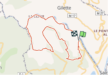
Trail of 11.1 km to be discovered at Provence-Alpes-Côte d'Azur, Maritime Alps, Le Broc. This trail is proposed by Renefrt.

Elevation profile

Positioning

Country:
France
Region :
Provence-Alpes-Côte d'Azur
Department/Province :
Maritime Alps
Municipality :
Le Broc
Location:
Unknown
Start:(Dec)
Start:(UTM)
353040 ; 4855304 (32T) N.

Comments

Please log in to post a review or rate the element


La faire dans ce sens, arrivé au parking après les barrières bien se diriger a droite de la maison chemin au ras de l'Esteron. Mon Garmin Etrex 35 m' a donné 16km et 377 m de dénivelé positif


Trails nearby

Trail On foot Bouyon - track - Photo
On foot
domi06

On foot

Medium
(1)
Bouyon, Provence-Alpes-Côte d'Azur, Maritime Alps, France
16 km | 29 km-effort
6h 0min
Yes
Trail Walking Le Broc - Mouton d'Annou depuis lac du broc réel - Photo
Walking
GUIDE
jouans

Walking

Very difficult
Le Broc, Provence-Alpes-Côte d'Azur, Maritime Alps, France
17 km | 30 km-effort
6h 52min
Yes
Trail Walking Utelle - Le Chaudan Madone Utelle réel - Photo
Walking
GUIDE
jouans

Walking

Very difficult
Utelle, Provence-Alpes-Côte d'Azur, Maritime Alps, France
19.6 km | 37 km-effort
5h 55min
Yes
Trail On foot Gilette - Tour du mont Lion - Photo
On foot
GUIDE+

On foot

Medium
Gilette, Provence-Alpes-Côte d'Azur, Maritime Alps, France
13.4 km | 25 km-effort
5h 44min
Yes
Trail On foot Carros - Les Balcons de Carros - Photo
On foot
GUIDE+

On foot

Easy
Carros, Provence-Alpes-Côte d'Azur, Maritime Alps, France
4.9 km | 9.1 km-effort
2h 4min
Yes
Trail On foot Bouyon - Gorges de l'Estéron - Photo
On foot
GUIDE+

On foot

Medium
Bouyon, Provence-Alpes-Côte d'Azur, Maritime Alps, France
12 km | 22 km-effort
5h 3min
Yes
Trail Walking Levens - Hike 2017 jour 1 - Photo
Walking
albert318

Walking

Very difficult
(1)
Levens, Provence-Alpes-Côte d'Azur, Maritime Alps, France
14.7 km | 29 km-effort
6h 27min
No
Trail Walking Le Broc - mouton d'anou depuis le broc - Photo
Walking
Michel06

Walking

Easy
(1)
Le Broc, Provence-Alpes-Côte d'Azur, Maritime Alps, France
14.3 km | 23 km-effort
5h 13min
Yes
Trail Walking Bonson - Plan du Var-Tourrette du Château  - Photo
Walking
ETMU5496

Walking

Difficult
Bonson, Provence-Alpes-Côte d'Azur, Maritime Alps, France
19.1 km | 35 km-effort
7h 50min
Yes


Close
My subscriptions