


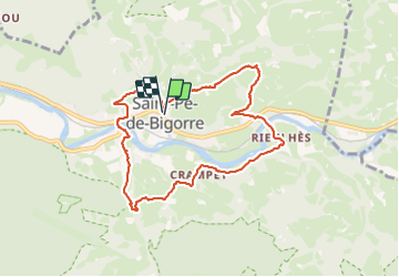

10.8 km | 13.8 km-effort

User GUIDE


FREE GPS app for hiking
 SityTrail
IGN / Geographical institutes
SityTrail World
The world is yours!
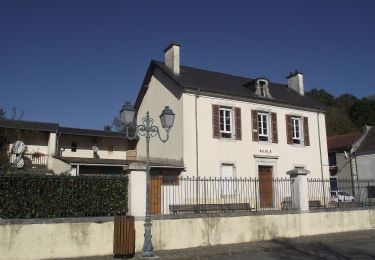
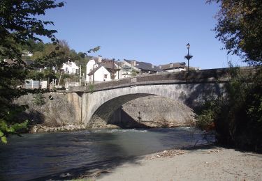
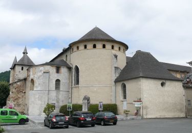
Trail Walking of 9 km to be discovered at Occitania, Hautespyrenees, Saint-Pé-de-Bigorre. This trail is proposed by marmotte65.
16 LPC au RDV 3 groupes constitues une belle balade à refaire mais avec la variante de la reco faite en décembre 2020 voir le N° ID 2621645
le temps indiqué ci-dessous est le temps effectif de marche 2h40 / 4h40 pauses comprises
coordonnée de depart N 43 06 12.0 W000 09 32.2
 "
data-pinterest-text="Pin it"
data-tweet-text="share on twitter"
data-facebook-share-url="https://www.sitytrail.com/en/trails/2661266-saintxpexdexbigorre--saint-pe-de-bigorre-et-ses-coteaux-g4--faite-avec-lpc-x2661266x/?photo=1#lg=1&slide=1"
data-twitter-share-url="https://www.sitytrail.com/en/trails/2661266-saintxpexdexbigorre--saint-pe-de-bigorre-et-ses-coteaux-g4--faite-avec-lpc-x2661266x/?photo=1#lg=1&slide=1"
data-googleplus-share-url="https://www.sitytrail.com/en/trails/2661266-saintxpexdexbigorre--saint-pe-de-bigorre-et-ses-coteaux-g4--faite-avec-lpc-x2661266x/?photo=1#lg=1&slide=1"
data-pinterest-share-url="https://www.sitytrail.com/en/trails/2661266-saintxpexdexbigorre--saint-pe-de-bigorre-et-ses-coteaux-g4--faite-avec-lpc-x2661266x/?photo=1#lg=1&slide=1">
"
data-pinterest-text="Pin it"
data-tweet-text="share on twitter"
data-facebook-share-url="https://www.sitytrail.com/en/trails/2661266-saintxpexdexbigorre--saint-pe-de-bigorre-et-ses-coteaux-g4--faite-avec-lpc-x2661266x/?photo=1#lg=1&slide=1"
data-twitter-share-url="https://www.sitytrail.com/en/trails/2661266-saintxpexdexbigorre--saint-pe-de-bigorre-et-ses-coteaux-g4--faite-avec-lpc-x2661266x/?photo=1#lg=1&slide=1"
data-googleplus-share-url="https://www.sitytrail.com/en/trails/2661266-saintxpexdexbigorre--saint-pe-de-bigorre-et-ses-coteaux-g4--faite-avec-lpc-x2661266x/?photo=1#lg=1&slide=1"
data-pinterest-share-url="https://www.sitytrail.com/en/trails/2661266-saintxpexdexbigorre--saint-pe-de-bigorre-et-ses-coteaux-g4--faite-avec-lpc-x2661266x/?photo=1#lg=1&slide=1">
 "
data-pinterest-text="Pin it"
data-tweet-text="share on twitter"
data-facebook-share-url="https://www.sitytrail.com/en/trails/2661266-saintxpexdexbigorre--saint-pe-de-bigorre-et-ses-coteaux-g4--faite-avec-lpc-x2661266x/?photo=2#lg=1&slide=2"
data-twitter-share-url="https://www.sitytrail.com/en/trails/2661266-saintxpexdexbigorre--saint-pe-de-bigorre-et-ses-coteaux-g4--faite-avec-lpc-x2661266x/?photo=2#lg=1&slide=2"
data-googleplus-share-url="https://www.sitytrail.com/en/trails/2661266-saintxpexdexbigorre--saint-pe-de-bigorre-et-ses-coteaux-g4--faite-avec-lpc-x2661266x/?photo=2#lg=1&slide=2"
data-pinterest-share-url="https://www.sitytrail.com/en/trails/2661266-saintxpexdexbigorre--saint-pe-de-bigorre-et-ses-coteaux-g4--faite-avec-lpc-x2661266x/?photo=2#lg=1&slide=2">
"
data-pinterest-text="Pin it"
data-tweet-text="share on twitter"
data-facebook-share-url="https://www.sitytrail.com/en/trails/2661266-saintxpexdexbigorre--saint-pe-de-bigorre-et-ses-coteaux-g4--faite-avec-lpc-x2661266x/?photo=2#lg=1&slide=2"
data-twitter-share-url="https://www.sitytrail.com/en/trails/2661266-saintxpexdexbigorre--saint-pe-de-bigorre-et-ses-coteaux-g4--faite-avec-lpc-x2661266x/?photo=2#lg=1&slide=2"
data-googleplus-share-url="https://www.sitytrail.com/en/trails/2661266-saintxpexdexbigorre--saint-pe-de-bigorre-et-ses-coteaux-g4--faite-avec-lpc-x2661266x/?photo=2#lg=1&slide=2"
data-pinterest-share-url="https://www.sitytrail.com/en/trails/2661266-saintxpexdexbigorre--saint-pe-de-bigorre-et-ses-coteaux-g4--faite-avec-lpc-x2661266x/?photo=2#lg=1&slide=2">
 "
data-pinterest-text="Pin it"
data-tweet-text="share on twitter"
data-facebook-share-url="https://www.sitytrail.com/en/trails/2661266-saintxpexdexbigorre--saint-pe-de-bigorre-et-ses-coteaux-g4--faite-avec-lpc-x2661266x/?photo=3#lg=1&slide=3"
data-twitter-share-url="https://www.sitytrail.com/en/trails/2661266-saintxpexdexbigorre--saint-pe-de-bigorre-et-ses-coteaux-g4--faite-avec-lpc-x2661266x/?photo=3#lg=1&slide=3"
data-googleplus-share-url="https://www.sitytrail.com/en/trails/2661266-saintxpexdexbigorre--saint-pe-de-bigorre-et-ses-coteaux-g4--faite-avec-lpc-x2661266x/?photo=3#lg=1&slide=3"
data-pinterest-share-url="https://www.sitytrail.com/en/trails/2661266-saintxpexdexbigorre--saint-pe-de-bigorre-et-ses-coteaux-g4--faite-avec-lpc-x2661266x/?photo=3#lg=1&slide=3">
"
data-pinterest-text="Pin it"
data-tweet-text="share on twitter"
data-facebook-share-url="https://www.sitytrail.com/en/trails/2661266-saintxpexdexbigorre--saint-pe-de-bigorre-et-ses-coteaux-g4--faite-avec-lpc-x2661266x/?photo=3#lg=1&slide=3"
data-twitter-share-url="https://www.sitytrail.com/en/trails/2661266-saintxpexdexbigorre--saint-pe-de-bigorre-et-ses-coteaux-g4--faite-avec-lpc-x2661266x/?photo=3#lg=1&slide=3"
data-googleplus-share-url="https://www.sitytrail.com/en/trails/2661266-saintxpexdexbigorre--saint-pe-de-bigorre-et-ses-coteaux-g4--faite-avec-lpc-x2661266x/?photo=3#lg=1&slide=3"
data-pinterest-share-url="https://www.sitytrail.com/en/trails/2661266-saintxpexdexbigorre--saint-pe-de-bigorre-et-ses-coteaux-g4--faite-avec-lpc-x2661266x/?photo=3#lg=1&slide=3">
 "
data-pinterest-text="Pin it"
data-tweet-text="share on twitter"
data-facebook-share-url="https://www.sitytrail.com/en/trails/2661266-saintxpexdexbigorre--saint-pe-de-bigorre-et-ses-coteaux-g4--faite-avec-lpc-x2661266x/?photo=4#lg=1&slide=4"
data-twitter-share-url="https://www.sitytrail.com/en/trails/2661266-saintxpexdexbigorre--saint-pe-de-bigorre-et-ses-coteaux-g4--faite-avec-lpc-x2661266x/?photo=4#lg=1&slide=4"
data-googleplus-share-url="https://www.sitytrail.com/en/trails/2661266-saintxpexdexbigorre--saint-pe-de-bigorre-et-ses-coteaux-g4--faite-avec-lpc-x2661266x/?photo=4#lg=1&slide=4"
data-pinterest-share-url="https://www.sitytrail.com/en/trails/2661266-saintxpexdexbigorre--saint-pe-de-bigorre-et-ses-coteaux-g4--faite-avec-lpc-x2661266x/?photo=4#lg=1&slide=4">
"
data-pinterest-text="Pin it"
data-tweet-text="share on twitter"
data-facebook-share-url="https://www.sitytrail.com/en/trails/2661266-saintxpexdexbigorre--saint-pe-de-bigorre-et-ses-coteaux-g4--faite-avec-lpc-x2661266x/?photo=4#lg=1&slide=4"
data-twitter-share-url="https://www.sitytrail.com/en/trails/2661266-saintxpexdexbigorre--saint-pe-de-bigorre-et-ses-coteaux-g4--faite-avec-lpc-x2661266x/?photo=4#lg=1&slide=4"
data-googleplus-share-url="https://www.sitytrail.com/en/trails/2661266-saintxpexdexbigorre--saint-pe-de-bigorre-et-ses-coteaux-g4--faite-avec-lpc-x2661266x/?photo=4#lg=1&slide=4"
data-pinterest-share-url="https://www.sitytrail.com/en/trails/2661266-saintxpexdexbigorre--saint-pe-de-bigorre-et-ses-coteaux-g4--faite-avec-lpc-x2661266x/?photo=4#lg=1&slide=4">
 "
data-pinterest-text="Pin it"
data-tweet-text="share on twitter"
data-facebook-share-url="https://www.sitytrail.com/en/trails/2661266-saintxpexdexbigorre--saint-pe-de-bigorre-et-ses-coteaux-g4--faite-avec-lpc-x2661266x/?photo=5#lg=1&slide=5"
data-twitter-share-url="https://www.sitytrail.com/en/trails/2661266-saintxpexdexbigorre--saint-pe-de-bigorre-et-ses-coteaux-g4--faite-avec-lpc-x2661266x/?photo=5#lg=1&slide=5"
data-googleplus-share-url="https://www.sitytrail.com/en/trails/2661266-saintxpexdexbigorre--saint-pe-de-bigorre-et-ses-coteaux-g4--faite-avec-lpc-x2661266x/?photo=5#lg=1&slide=5"
data-pinterest-share-url="https://www.sitytrail.com/en/trails/2661266-saintxpexdexbigorre--saint-pe-de-bigorre-et-ses-coteaux-g4--faite-avec-lpc-x2661266x/?photo=5#lg=1&slide=5">
"
data-pinterest-text="Pin it"
data-tweet-text="share on twitter"
data-facebook-share-url="https://www.sitytrail.com/en/trails/2661266-saintxpexdexbigorre--saint-pe-de-bigorre-et-ses-coteaux-g4--faite-avec-lpc-x2661266x/?photo=5#lg=1&slide=5"
data-twitter-share-url="https://www.sitytrail.com/en/trails/2661266-saintxpexdexbigorre--saint-pe-de-bigorre-et-ses-coteaux-g4--faite-avec-lpc-x2661266x/?photo=5#lg=1&slide=5"
data-googleplus-share-url="https://www.sitytrail.com/en/trails/2661266-saintxpexdexbigorre--saint-pe-de-bigorre-et-ses-coteaux-g4--faite-avec-lpc-x2661266x/?photo=5#lg=1&slide=5"
data-pinterest-share-url="https://www.sitytrail.com/en/trails/2661266-saintxpexdexbigorre--saint-pe-de-bigorre-et-ses-coteaux-g4--faite-avec-lpc-x2661266x/?photo=5#lg=1&slide=5">
 "
data-pinterest-text="Pin it"
data-tweet-text="share on twitter"
data-facebook-share-url="https://www.sitytrail.com/en/trails/2661266-saintxpexdexbigorre--saint-pe-de-bigorre-et-ses-coteaux-g4--faite-avec-lpc-x2661266x/?photo=6#lg=1&slide=6"
data-twitter-share-url="https://www.sitytrail.com/en/trails/2661266-saintxpexdexbigorre--saint-pe-de-bigorre-et-ses-coteaux-g4--faite-avec-lpc-x2661266x/?photo=6#lg=1&slide=6"
data-googleplus-share-url="https://www.sitytrail.com/en/trails/2661266-saintxpexdexbigorre--saint-pe-de-bigorre-et-ses-coteaux-g4--faite-avec-lpc-x2661266x/?photo=6#lg=1&slide=6"
data-pinterest-share-url="https://www.sitytrail.com/en/trails/2661266-saintxpexdexbigorre--saint-pe-de-bigorre-et-ses-coteaux-g4--faite-avec-lpc-x2661266x/?photo=6#lg=1&slide=6">
"
data-pinterest-text="Pin it"
data-tweet-text="share on twitter"
data-facebook-share-url="https://www.sitytrail.com/en/trails/2661266-saintxpexdexbigorre--saint-pe-de-bigorre-et-ses-coteaux-g4--faite-avec-lpc-x2661266x/?photo=6#lg=1&slide=6"
data-twitter-share-url="https://www.sitytrail.com/en/trails/2661266-saintxpexdexbigorre--saint-pe-de-bigorre-et-ses-coteaux-g4--faite-avec-lpc-x2661266x/?photo=6#lg=1&slide=6"
data-googleplus-share-url="https://www.sitytrail.com/en/trails/2661266-saintxpexdexbigorre--saint-pe-de-bigorre-et-ses-coteaux-g4--faite-avec-lpc-x2661266x/?photo=6#lg=1&slide=6"
data-pinterest-share-url="https://www.sitytrail.com/en/trails/2661266-saintxpexdexbigorre--saint-pe-de-bigorre-et-ses-coteaux-g4--faite-avec-lpc-x2661266x/?photo=6#lg=1&slide=6">
 "
data-pinterest-text="Pin it"
data-tweet-text="share on twitter"
data-facebook-share-url="https://www.sitytrail.com/en/trails/2661266-saintxpexdexbigorre--saint-pe-de-bigorre-et-ses-coteaux-g4--faite-avec-lpc-x2661266x/?photo=7#lg=1&slide=7"
data-twitter-share-url="https://www.sitytrail.com/en/trails/2661266-saintxpexdexbigorre--saint-pe-de-bigorre-et-ses-coteaux-g4--faite-avec-lpc-x2661266x/?photo=7#lg=1&slide=7"
data-googleplus-share-url="https://www.sitytrail.com/en/trails/2661266-saintxpexdexbigorre--saint-pe-de-bigorre-et-ses-coteaux-g4--faite-avec-lpc-x2661266x/?photo=7#lg=1&slide=7"
data-pinterest-share-url="https://www.sitytrail.com/en/trails/2661266-saintxpexdexbigorre--saint-pe-de-bigorre-et-ses-coteaux-g4--faite-avec-lpc-x2661266x/?photo=7#lg=1&slide=7">
"
data-pinterest-text="Pin it"
data-tweet-text="share on twitter"
data-facebook-share-url="https://www.sitytrail.com/en/trails/2661266-saintxpexdexbigorre--saint-pe-de-bigorre-et-ses-coteaux-g4--faite-avec-lpc-x2661266x/?photo=7#lg=1&slide=7"
data-twitter-share-url="https://www.sitytrail.com/en/trails/2661266-saintxpexdexbigorre--saint-pe-de-bigorre-et-ses-coteaux-g4--faite-avec-lpc-x2661266x/?photo=7#lg=1&slide=7"
data-googleplus-share-url="https://www.sitytrail.com/en/trails/2661266-saintxpexdexbigorre--saint-pe-de-bigorre-et-ses-coteaux-g4--faite-avec-lpc-x2661266x/?photo=7#lg=1&slide=7"
data-pinterest-share-url="https://www.sitytrail.com/en/trails/2661266-saintxpexdexbigorre--saint-pe-de-bigorre-et-ses-coteaux-g4--faite-avec-lpc-x2661266x/?photo=7#lg=1&slide=7">
 "
data-pinterest-text="Pin it"
data-tweet-text="share on twitter"
data-facebook-share-url="https://www.sitytrail.com/en/trails/2661266-saintxpexdexbigorre--saint-pe-de-bigorre-et-ses-coteaux-g4--faite-avec-lpc-x2661266x/?photo=8#lg=1&slide=8"
data-twitter-share-url="https://www.sitytrail.com/en/trails/2661266-saintxpexdexbigorre--saint-pe-de-bigorre-et-ses-coteaux-g4--faite-avec-lpc-x2661266x/?photo=8#lg=1&slide=8"
data-googleplus-share-url="https://www.sitytrail.com/en/trails/2661266-saintxpexdexbigorre--saint-pe-de-bigorre-et-ses-coteaux-g4--faite-avec-lpc-x2661266x/?photo=8#lg=1&slide=8"
data-pinterest-share-url="https://www.sitytrail.com/en/trails/2661266-saintxpexdexbigorre--saint-pe-de-bigorre-et-ses-coteaux-g4--faite-avec-lpc-x2661266x/?photo=8#lg=1&slide=8">
"
data-pinterest-text="Pin it"
data-tweet-text="share on twitter"
data-facebook-share-url="https://www.sitytrail.com/en/trails/2661266-saintxpexdexbigorre--saint-pe-de-bigorre-et-ses-coteaux-g4--faite-avec-lpc-x2661266x/?photo=8#lg=1&slide=8"
data-twitter-share-url="https://www.sitytrail.com/en/trails/2661266-saintxpexdexbigorre--saint-pe-de-bigorre-et-ses-coteaux-g4--faite-avec-lpc-x2661266x/?photo=8#lg=1&slide=8"
data-googleplus-share-url="https://www.sitytrail.com/en/trails/2661266-saintxpexdexbigorre--saint-pe-de-bigorre-et-ses-coteaux-g4--faite-avec-lpc-x2661266x/?photo=8#lg=1&slide=8"
data-pinterest-share-url="https://www.sitytrail.com/en/trails/2661266-saintxpexdexbigorre--saint-pe-de-bigorre-et-ses-coteaux-g4--faite-avec-lpc-x2661266x/?photo=8#lg=1&slide=8">
 "
data-pinterest-text="Pin it"
data-tweet-text="share on twitter"
data-facebook-share-url="https://www.sitytrail.com/en/trails/2661266-saintxpexdexbigorre--saint-pe-de-bigorre-et-ses-coteaux-g4--faite-avec-lpc-x2661266x/?photo=9#lg=1&slide=9"
data-twitter-share-url="https://www.sitytrail.com/en/trails/2661266-saintxpexdexbigorre--saint-pe-de-bigorre-et-ses-coteaux-g4--faite-avec-lpc-x2661266x/?photo=9#lg=1&slide=9"
data-googleplus-share-url="https://www.sitytrail.com/en/trails/2661266-saintxpexdexbigorre--saint-pe-de-bigorre-et-ses-coteaux-g4--faite-avec-lpc-x2661266x/?photo=9#lg=1&slide=9"
data-pinterest-share-url="https://www.sitytrail.com/en/trails/2661266-saintxpexdexbigorre--saint-pe-de-bigorre-et-ses-coteaux-g4--faite-avec-lpc-x2661266x/?photo=9#lg=1&slide=9">
"
data-pinterest-text="Pin it"
data-tweet-text="share on twitter"
data-facebook-share-url="https://www.sitytrail.com/en/trails/2661266-saintxpexdexbigorre--saint-pe-de-bigorre-et-ses-coteaux-g4--faite-avec-lpc-x2661266x/?photo=9#lg=1&slide=9"
data-twitter-share-url="https://www.sitytrail.com/en/trails/2661266-saintxpexdexbigorre--saint-pe-de-bigorre-et-ses-coteaux-g4--faite-avec-lpc-x2661266x/?photo=9#lg=1&slide=9"
data-googleplus-share-url="https://www.sitytrail.com/en/trails/2661266-saintxpexdexbigorre--saint-pe-de-bigorre-et-ses-coteaux-g4--faite-avec-lpc-x2661266x/?photo=9#lg=1&slide=9"
data-pinterest-share-url="https://www.sitytrail.com/en/trails/2661266-saintxpexdexbigorre--saint-pe-de-bigorre-et-ses-coteaux-g4--faite-avec-lpc-x2661266x/?photo=9#lg=1&slide=9">
 "
data-pinterest-text="Pin it"
data-tweet-text="share on twitter"
data-facebook-share-url="https://www.sitytrail.com/en/trails/2661266-saintxpexdexbigorre--saint-pe-de-bigorre-et-ses-coteaux-g4--faite-avec-lpc-x2661266x/?photo=10#lg=1&slide=10"
data-twitter-share-url="https://www.sitytrail.com/en/trails/2661266-saintxpexdexbigorre--saint-pe-de-bigorre-et-ses-coteaux-g4--faite-avec-lpc-x2661266x/?photo=10#lg=1&slide=10"
data-googleplus-share-url="https://www.sitytrail.com/en/trails/2661266-saintxpexdexbigorre--saint-pe-de-bigorre-et-ses-coteaux-g4--faite-avec-lpc-x2661266x/?photo=10#lg=1&slide=10"
data-pinterest-share-url="https://www.sitytrail.com/en/trails/2661266-saintxpexdexbigorre--saint-pe-de-bigorre-et-ses-coteaux-g4--faite-avec-lpc-x2661266x/?photo=10#lg=1&slide=10">
"
data-pinterest-text="Pin it"
data-tweet-text="share on twitter"
data-facebook-share-url="https://www.sitytrail.com/en/trails/2661266-saintxpexdexbigorre--saint-pe-de-bigorre-et-ses-coteaux-g4--faite-avec-lpc-x2661266x/?photo=10#lg=1&slide=10"
data-twitter-share-url="https://www.sitytrail.com/en/trails/2661266-saintxpexdexbigorre--saint-pe-de-bigorre-et-ses-coteaux-g4--faite-avec-lpc-x2661266x/?photo=10#lg=1&slide=10"
data-googleplus-share-url="https://www.sitytrail.com/en/trails/2661266-saintxpexdexbigorre--saint-pe-de-bigorre-et-ses-coteaux-g4--faite-avec-lpc-x2661266x/?photo=10#lg=1&slide=10"
data-pinterest-share-url="https://www.sitytrail.com/en/trails/2661266-saintxpexdexbigorre--saint-pe-de-bigorre-et-ses-coteaux-g4--faite-avec-lpc-x2661266x/?photo=10#lg=1&slide=10">
 "
data-pinterest-text="Pin it"
data-tweet-text="share on twitter"
data-facebook-share-url="https://www.sitytrail.com/en/trails/2661266-saintxpexdexbigorre--saint-pe-de-bigorre-et-ses-coteaux-g4--faite-avec-lpc-x2661266x/?photo=11#lg=1&slide=11"
data-twitter-share-url="https://www.sitytrail.com/en/trails/2661266-saintxpexdexbigorre--saint-pe-de-bigorre-et-ses-coteaux-g4--faite-avec-lpc-x2661266x/?photo=11#lg=1&slide=11"
data-googleplus-share-url="https://www.sitytrail.com/en/trails/2661266-saintxpexdexbigorre--saint-pe-de-bigorre-et-ses-coteaux-g4--faite-avec-lpc-x2661266x/?photo=11#lg=1&slide=11"
data-pinterest-share-url="https://www.sitytrail.com/en/trails/2661266-saintxpexdexbigorre--saint-pe-de-bigorre-et-ses-coteaux-g4--faite-avec-lpc-x2661266x/?photo=11#lg=1&slide=11">
"
data-pinterest-text="Pin it"
data-tweet-text="share on twitter"
data-facebook-share-url="https://www.sitytrail.com/en/trails/2661266-saintxpexdexbigorre--saint-pe-de-bigorre-et-ses-coteaux-g4--faite-avec-lpc-x2661266x/?photo=11#lg=1&slide=11"
data-twitter-share-url="https://www.sitytrail.com/en/trails/2661266-saintxpexdexbigorre--saint-pe-de-bigorre-et-ses-coteaux-g4--faite-avec-lpc-x2661266x/?photo=11#lg=1&slide=11"
data-googleplus-share-url="https://www.sitytrail.com/en/trails/2661266-saintxpexdexbigorre--saint-pe-de-bigorre-et-ses-coteaux-g4--faite-avec-lpc-x2661266x/?photo=11#lg=1&slide=11"
data-pinterest-share-url="https://www.sitytrail.com/en/trails/2661266-saintxpexdexbigorre--saint-pe-de-bigorre-et-ses-coteaux-g4--faite-avec-lpc-x2661266x/?photo=11#lg=1&slide=11">
 "
data-pinterest-text="Pin it"
data-tweet-text="share on twitter"
data-facebook-share-url="https://www.sitytrail.com/en/trails/2661266-saintxpexdexbigorre--saint-pe-de-bigorre-et-ses-coteaux-g4--faite-avec-lpc-x2661266x/?photo=12#lg=1&slide=12"
data-twitter-share-url="https://www.sitytrail.com/en/trails/2661266-saintxpexdexbigorre--saint-pe-de-bigorre-et-ses-coteaux-g4--faite-avec-lpc-x2661266x/?photo=12#lg=1&slide=12"
data-googleplus-share-url="https://www.sitytrail.com/en/trails/2661266-saintxpexdexbigorre--saint-pe-de-bigorre-et-ses-coteaux-g4--faite-avec-lpc-x2661266x/?photo=12#lg=1&slide=12"
data-pinterest-share-url="https://www.sitytrail.com/en/trails/2661266-saintxpexdexbigorre--saint-pe-de-bigorre-et-ses-coteaux-g4--faite-avec-lpc-x2661266x/?photo=12#lg=1&slide=12">
"
data-pinterest-text="Pin it"
data-tweet-text="share on twitter"
data-facebook-share-url="https://www.sitytrail.com/en/trails/2661266-saintxpexdexbigorre--saint-pe-de-bigorre-et-ses-coteaux-g4--faite-avec-lpc-x2661266x/?photo=12#lg=1&slide=12"
data-twitter-share-url="https://www.sitytrail.com/en/trails/2661266-saintxpexdexbigorre--saint-pe-de-bigorre-et-ses-coteaux-g4--faite-avec-lpc-x2661266x/?photo=12#lg=1&slide=12"
data-googleplus-share-url="https://www.sitytrail.com/en/trails/2661266-saintxpexdexbigorre--saint-pe-de-bigorre-et-ses-coteaux-g4--faite-avec-lpc-x2661266x/?photo=12#lg=1&slide=12"
data-pinterest-share-url="https://www.sitytrail.com/en/trails/2661266-saintxpexdexbigorre--saint-pe-de-bigorre-et-ses-coteaux-g4--faite-avec-lpc-x2661266x/?photo=12#lg=1&slide=12">
 "
data-pinterest-text="Pin it"
data-tweet-text="share on twitter"
data-facebook-share-url="https://www.sitytrail.com/en/trails/2661266-saintxpexdexbigorre--saint-pe-de-bigorre-et-ses-coteaux-g4--faite-avec-lpc-x2661266x/?photo=13#lg=1&slide=13"
data-twitter-share-url="https://www.sitytrail.com/en/trails/2661266-saintxpexdexbigorre--saint-pe-de-bigorre-et-ses-coteaux-g4--faite-avec-lpc-x2661266x/?photo=13#lg=1&slide=13"
data-googleplus-share-url="https://www.sitytrail.com/en/trails/2661266-saintxpexdexbigorre--saint-pe-de-bigorre-et-ses-coteaux-g4--faite-avec-lpc-x2661266x/?photo=13#lg=1&slide=13"
data-pinterest-share-url="https://www.sitytrail.com/en/trails/2661266-saintxpexdexbigorre--saint-pe-de-bigorre-et-ses-coteaux-g4--faite-avec-lpc-x2661266x/?photo=13#lg=1&slide=13">
"
data-pinterest-text="Pin it"
data-tweet-text="share on twitter"
data-facebook-share-url="https://www.sitytrail.com/en/trails/2661266-saintxpexdexbigorre--saint-pe-de-bigorre-et-ses-coteaux-g4--faite-avec-lpc-x2661266x/?photo=13#lg=1&slide=13"
data-twitter-share-url="https://www.sitytrail.com/en/trails/2661266-saintxpexdexbigorre--saint-pe-de-bigorre-et-ses-coteaux-g4--faite-avec-lpc-x2661266x/?photo=13#lg=1&slide=13"
data-googleplus-share-url="https://www.sitytrail.com/en/trails/2661266-saintxpexdexbigorre--saint-pe-de-bigorre-et-ses-coteaux-g4--faite-avec-lpc-x2661266x/?photo=13#lg=1&slide=13"
data-pinterest-share-url="https://www.sitytrail.com/en/trails/2661266-saintxpexdexbigorre--saint-pe-de-bigorre-et-ses-coteaux-g4--faite-avec-lpc-x2661266x/?photo=13#lg=1&slide=13">


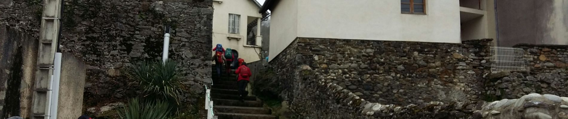
Walking
On foot
On foot
On foot
On foot
On foot

Walking

Walking
On foot