![](/images/other/stat-length.png)
![Trail Mountain bike Jullié - Les 2 roches en boucle depuis Jullié - Photo](https://media.geolcdn.com/t/1900/400/ext.pjpeg?maxdim=2&url=https%3A%2F%2Fstatic1.geolcdn.com%2Fsiteimages%2Fupload%2Ffiles%2F1524743154velo.jpg)
Les 2 roches en boucle depuis Jullié
Nicolas Bajard
User
![Length](/images/other/stat-length.png)
Length
36 km
![Max alt](https://static1.geolcdn.com/siteimages/upload/files/1508320355ic_sort_altitude_max_24dp.png)
Max alt
742 m
![Uphill gradient](https://static1.geolcdn.com/siteimages/upload/files/1508320355ic_sort_den_pos_24dp.png)
Uphill gradient
1431 m
![Km-Effort](/images/other/stat-length.png)
Km-Effort
55 km
![Min alt](https://static1.geolcdn.com/siteimages/upload/files/1508320355ic_sort_altitude_min_24dp.png)
Min alt
227 m
![Downhill gradient](https://static1.geolcdn.com/siteimages/upload/files/1508320355ic_sort_den_neg_24dp.png)
Downhill gradient
1413 m
![Boucle](https://static1.geolcdn.com/siteimages/upload/files/16400158638029165_repeat_loop_refresh_sync_direction_icon.png)
Boucle
Yes
Creation date :
2021-02-04 20:04:43.159
Updated on :
2021-02-05 18:38:16.026
![Mountain bike](https://static1.geolcdn.com/sitytour/trail-icons/202.png)
3h50
Difficulty : Very difficult
![Scan this QR Code to open this trail in the SityTrail application](https://capi.geolives.com/qq0zvz2zws4bq2lad0pu/sitytour/trails/2660851/qr.png?size=200)
FREE GPS app for hiking
About
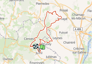
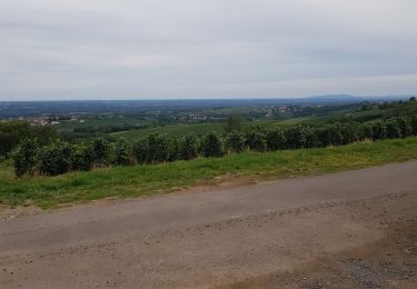
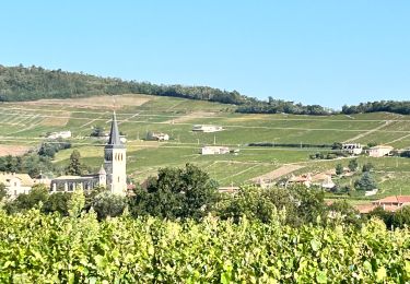
Trail Mountain bike of 36 km to be discovered at Auvergne-Rhône-Alpes, Rhône, Jullié. This trail is proposed by Nicolas Bajard.
Description
Départ de Jullié direction les crêtes par Gerbet. contour de la roche de Vergisson, puis cap au sud vers Solutré. Retour Sur Pruzilly.
on peut éviter la remontée sur la X du Plassy et Télégraphe, pour tracer directement du Bourg de Pruzilly vers Jullié.
Positioning
Country:
France
Region :
Auvergne-Rhône-Alpes
Department/Province :
Rhône
Municipality :
Jullié
Location:
Unknown
Start:(Dec)
Start:(UTM)
629337 ; 5122311 (31T) N.
Comments
Trails nearby
![Trail Walking Vauxrenard - Itinérant Beaujolais rouge étape 6 Foretal - Macon gare TGV - Photo](https://media.geolcdn.com/t/375/260/413cab1b-506e-4c3e-962c-5987ea1a88f6.jpg&format=jpg&maxdim=2)
![Walking Walking](https://static1.geolcdn.com/sitytour/trail-icons/101.png)
Itinérant Beaujolais rouge étape 6 Foretal - Macon gare TGV
Walking
Very difficult
Vauxrenard,
Auvergne-Rhône-Alpes,
Rhône,
France
![](/images/other/stat-length.png)
23 km | 28 km-effort
6h 26min
![](https://static1.geolcdn.com/siteimages/upload/files/16400158638029165_repeat_loop_refresh_sync_direction_icon.png)
No
![Trail Walking Vauxrenard - vauxrenard - Photo](https://media.geolcdn.com/t/375/260/ext.jpg?maxdim=2&url=https%3A%2F%2Fstatic1.geolcdn.com%2Fsiteimages%2Fupload%2Ffiles%2F1553511878bg_sport_marche.png)
![Walking Walking](https://static1.geolcdn.com/sitytour/trail-icons/101.png)
vauxrenard
Walking
Difficult
(1)
Vauxrenard,
Auvergne-Rhône-Alpes,
Rhône,
France
![](/images/other/stat-length.png)
21 km | 31 km-effort
5h 7min
![](https://static1.geolcdn.com/siteimages/upload/files/16400158638029165_repeat_loop_refresh_sync_direction_icon.png)
Yes
![Trail Walking Chénas - Chénas - Le Venet - Photo](https://media.geolcdn.com/t/375/260/d8ea6745-554d-47dd-be4a-fb50b3697e17.jpeg&format=jpg&maxdim=2)
![Walking Walking](https://static1.geolcdn.com/sitytour/trail-icons/101.png)
Chénas - Le Venet
Walking
Very easy
Chénas,
Auvergne-Rhône-Alpes,
Rhône,
France
![](/images/other/stat-length.png)
3.4 km | 4.5 km-effort
1h 1min
![](https://static1.geolcdn.com/siteimages/upload/files/16400158638029165_repeat_loop_refresh_sync_direction_icon.png)
Yes
![Trail Walking Leynes - LEYNES 71 - Photo](https://media.geolcdn.com/t/375/260/61b56629-d697-45a7-bb0d-bd0fe620434d.jpg&format=jpg&maxdim=2)
![Walking Walking](https://static1.geolcdn.com/sitytour/trail-icons/101.png)
LEYNES 71
Walking
Difficult
Leynes,
Bourgogne-Franche-Comté,
Saône-et-Loire,
France
![](/images/other/stat-length.png)
9.5 km | 12.7 km-effort
2h 38min
![](https://static1.geolcdn.com/siteimages/upload/files/16400158638029165_repeat_loop_refresh_sync_direction_icon.png)
Yes
![Trail Walking Cenves - cenves la madone - Photo](https://media.geolcdn.com/t/375/260/a381df5f-0cf9-4146-a04a-b176620d4d7d.jpg&format=jpg&maxdim=2)
![Walking Walking](https://static1.geolcdn.com/sitytour/trail-icons/101.png)
cenves la madone
Walking
Very difficult
Cenves,
Auvergne-Rhône-Alpes,
Rhône,
France
![](/images/other/stat-length.png)
16.6 km | 26 km-effort
6h 0min
![](https://static1.geolcdn.com/siteimages/upload/files/16400158638029165_repeat_loop_refresh_sync_direction_icon.png)
Yes
![Trail Walking Chasselas - Chasselas (Saône- et-Loire région Bourgogne) - Photo](https://media.geolcdn.com/t/375/260/a1e39a90-d3b1-40f6-b80a-42d8086a07ac.jpg&format=jpg&maxdim=2)
![Walking Walking](https://static1.geolcdn.com/sitytour/trail-icons/101.png)
Chasselas (Saône- et-Loire région Bourgogne)
Walking
Difficult
Chasselas,
Bourgogne-Franche-Comté,
Saône-et-Loire,
France
![](/images/other/stat-length.png)
15.1 km | 23 km-effort
5h 34min
![](https://static1.geolcdn.com/siteimages/upload/files/16400158638029165_repeat_loop_refresh_sync_direction_icon.png)
Yes
![Trail Walking Cenves - Cenves](https://media.geolcdn.com/t/375/260/e37d4c40-86a6-4702-8656-51d1279bf78a.jpeg&format=jpg&maxdim=2)
![Walking Walking](https://static1.geolcdn.com/sitytour/trail-icons/101.png)
Cenves "circuit des pentes" (14 km - D 643 m)
Walking
Difficult
Cenves,
Auvergne-Rhône-Alpes,
Rhône,
France
![](/images/other/stat-length.png)
14.2 km | 23 km-effort
5h 2min
![](https://static1.geolcdn.com/siteimages/upload/files/16400158638029165_repeat_loop_refresh_sync_direction_icon.png)
Yes
![Trail Running Juliénas - jour 1 CAP Jeanot - Photo](https://media.geolcdn.com/t/375/260/13a91d92-1c30-4881-aeb7-c1c040badea9.jpg&format=jpg&maxdim=2)
![Running Running](https://static1.geolcdn.com/sitytour/trail-icons/103.png)
jour 1 CAP Jeanot
Running
Very easy
Juliénas,
Auvergne-Rhône-Alpes,
Rhône,
France
![](/images/other/stat-length.png)
26 km | 38 km-effort
3h 41min
![](https://static1.geolcdn.com/siteimages/upload/files/16400158638029165_repeat_loop_refresh_sync_direction_icon.png)
No
![Trail Walking Chénas - Chenas - Le Venet (2) - Photo](https://media.geolcdn.com/t/375/260/84362a50-f819-4345-99da-3ae671607f38.jpeg&format=jpg&maxdim=2)
![Walking Walking](https://static1.geolcdn.com/sitytour/trail-icons/101.png)
Chenas - Le Venet (2)
Walking
Easy
Chénas,
Auvergne-Rhône-Alpes,
Rhône,
France
![](/images/other/stat-length.png)
5.7 km | 7.6 km-effort
1h 43min
![](https://static1.geolcdn.com/siteimages/upload/files/16400158638029165_repeat_loop_refresh_sync_direction_icon.png)
Yes