![](/images/other/stat-length.png)
![Trail Kiischpelt - 2021-02-02_19h23m09_Cirkwi-Escapardenne_Eislek_Trail_-_Etape_1_-_Kautenbach_-_Clervaux-2 - Photo](https://media.geolcdn.com/t/1900/400/ext.pjpeg?maxdim=2&url=https%3A%2F%2Fsecurestorage.geolives.com%2Fsitytour%2Ftrail-bg%2Fdefault.jpg)
2021-02-02_19h23m09_Cirkwi-Escapardenne_Eislek_Trail_-_Etape_1_-_Kautenbach_-_Clervaux-2
mariedelustin
User
![Length](/images/other/stat-length.png)
![Max alt](https://static1.geolcdn.com/siteimages/upload/files/1508320355ic_sort_altitude_max_24dp.png)
![Uphill gradient](https://static1.geolcdn.com/siteimages/upload/files/1508320355ic_sort_den_pos_24dp.png)
![Km-Effort](/images/other/stat-length.png)
![Min alt](https://static1.geolcdn.com/siteimages/upload/files/1508320355ic_sort_altitude_min_24dp.png)
![Downhill gradient](https://static1.geolcdn.com/siteimages/upload/files/1508320355ic_sort_den_neg_24dp.png)
![Boucle](https://static1.geolcdn.com/siteimages/upload/files/16400158638029165_repeat_loop_refresh_sync_direction_icon.png)
![Scan this QR Code to open this trail in the SityTrail application](https://capi.geolives.com/qq0zvz2zws4bq2lad0pu/sitytour/trails/2658834/qr.png?size=200)
FREE GPS app for hiking
About
Trail of 24 km to be discovered at Unknown, Canton Wiltz, Kiischpelt. This trail is proposed by mariedelustin.
Description
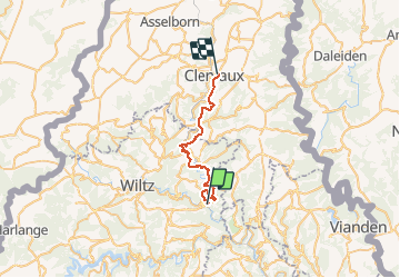
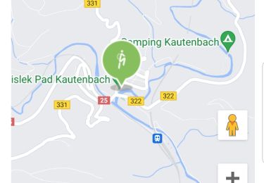
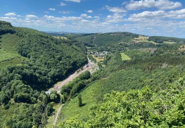
A Kautenbach et plus précisément au Park&Ride de la gare se trouve le point de départ de l’Escapardenne Eislek Trail. La randonnée débute avec une pente raide par l’ancien chemin destiné au bétail pour ensuite tourner sur les hauteurs en direction d’Alscheid. Après une descente vers le camping, la randonnée passe par le chemin des écrevisses afin de rejoindre la Schibberich avant de retomber dans la vallée. L’itinéraire continue en direction de Lellingen et débouche notamment sur un point de vu où vous pourrez admirer le Kischpelt. En ralliant le fond vallée, une escale dans l’authentique village de Lellingen est possible. Ensuite, la randonnée emprunte le chemin asphalté du côté gauche de la voie ferrée, passe par le rocher « Geeslay » pour rallier les villages de Wilwerwiltz et d’Enscherange. Après une montée sur le plateau près d’Enscherange, de magnifiques vues sur le Kiischpelt se présentent. En passant par les taillis près de la butte du « Walber », vous poursuivez votre chemin en direction de la vallée de l’Irbach. Enfin, la randonnée passe par le pont « Nol », où il est possible de rejoindre le village de Munshausen, pour finalement rejoindre la gare de Clervaux, arrivée de la première étape.
Positioning
Comments
Trails nearby
![Trail Walking Goesdorf - Autopedestres : Dahl - Photo](https://media.geolcdn.com/t/375/260/ext.jpg?maxdim=2&url=https%3A%2F%2Fstatic1.geolcdn.com%2Fsiteimages%2Fupload%2Ffiles%2F1553511878bg_sport_marche.png)
![Walking Walking](https://static1.geolcdn.com/sitytour/trail-icons/101.png)
Walking
![](/images/other/stat-length.png)
![](https://static1.geolcdn.com/siteimages/upload/files/16400158638029165_repeat_loop_refresh_sync_direction_icon.png)
![Trail Walking Bourscheid - Autopedestres : Bourscheid - Photo](https://media.geolcdn.com/t/375/260/ext.jpg?maxdim=2&url=https%3A%2F%2Fstatic1.geolcdn.com%2Fsiteimages%2Fupload%2Ffiles%2F1553511878bg_sport_marche.png)
![Walking Walking](https://static1.geolcdn.com/sitytour/trail-icons/101.png)
Walking
![](/images/other/stat-length.png)
![](https://static1.geolcdn.com/siteimages/upload/files/16400158638029165_repeat_loop_refresh_sync_direction_icon.png)
![Trail Walking Kiischpelt - eislek trail de Kautenbach à Troisvierges - Photo](https://media.geolcdn.com/t/375/260/fa22f2d8-d5f7-4d5a-bd3c-5a3522af9299.jpg&format=jpg&maxdim=2)
![Walking Walking](https://static1.geolcdn.com/sitytour/trail-icons/101.png)
Walking
![](/images/other/stat-length.png)
![](https://static1.geolcdn.com/siteimages/upload/files/16400158638029165_repeat_loop_refresh_sync_direction_icon.png)
![Trail Walking Kiischpelt - 2023-06-19_15h16m15_eislek-pad-lellingen-1 - Photo](https://media.geolcdn.com/t/375/260/b5d867db-7edb-46bc-9488-bc2835d5be2c.jpg&format=jpg&maxdim=2)
![Walking Walking](https://static1.geolcdn.com/sitytour/trail-icons/101.png)
Walking
![](/images/other/stat-length.png)
![](https://static1.geolcdn.com/siteimages/upload/files/16400158638029165_repeat_loop_refresh_sync_direction_icon.png)
![Trail Walking Kiischpelt - Enscherange 8,2 km - Photo](https://media.geolcdn.com/t/375/260/68f5dba6-bf4e-43e0-a8e3-925d34efebea.jpg&format=jpg&maxdim=2)
![Walking Walking](https://static1.geolcdn.com/sitytour/trail-icons/101.png)
Walking
![](/images/other/stat-length.png)
![](https://static1.geolcdn.com/siteimages/upload/files/16400158638029165_repeat_loop_refresh_sync_direction_icon.png)
![Trail Walking Kiischpelt - 2022-09-22_13h29m24_t62885235_eislek pad kautenbach (1) - Photo](https://media.geolcdn.com/t/375/260/0c0135b5-3869-4e5e-9de6-2c826fdc4a40.jpg&format=jpg&maxdim=2)
![Walking Walking](https://static1.geolcdn.com/sitytour/trail-icons/101.png)
Walking
![](/images/other/stat-length.png)
![](https://static1.geolcdn.com/siteimages/upload/files/16400158638029165_repeat_loop_refresh_sync_direction_icon.png)
![Trail Walking Bourscheid - 2022-09-22_13h10m58_t62880921_eislek pad bourscheid - Photo](https://media.geolcdn.com/t/375/260/22286de4-94ea-4b92-acbb-a4fc138a2ba8.jpg&format=jpg&maxdim=2)
![Walking Walking](https://static1.geolcdn.com/sitytour/trail-icons/101.png)
Walking
![](/images/other/stat-length.png)
![](https://static1.geolcdn.com/siteimages/upload/files/16400158638029165_repeat_loop_refresh_sync_direction_icon.png)
![Trail Walking Kiischpelt - Escapardenne Eisleck Trail: Kautenbach - Clervaux - Photo](https://media.geolcdn.com/t/375/260/86b391f6-6800-4c48-b33b-03a021b1a218.jpeg&format=jpg&maxdim=2)
![Walking Walking](https://static1.geolcdn.com/sitytour/trail-icons/101.png)
Walking
![](/images/other/stat-length.png)
![](https://static1.geolcdn.com/siteimages/upload/files/16400158638029165_repeat_loop_refresh_sync_direction_icon.png)
![Trail Walking Parc Hosingen - Escapardenne Lee Trail: Hoscheid - Kautenbach - Photo](https://media.geolcdn.com/t/375/260/8bf23a72-7eca-4436-91e5-2141dda4e2a9.jpeg&format=jpg&maxdim=2)
![Walking Walking](https://static1.geolcdn.com/sitytour/trail-icons/101.png)
Walking
![](/images/other/stat-length.png)
![](https://static1.geolcdn.com/siteimages/upload/files/16400158638029165_repeat_loop_refresh_sync_direction_icon.png)