![](/images/other/stat-length.png)
![Trail Walking Moret-Loing-et-Orvanne - Boucle Moret sur Loing - Montigny sur Loing + Forêt de Fontainebleau - Photo](https://media.geolcdn.com/t/1900/400/84f8eada-7062-461f-a65b-32d1ee356940.jpg&format=pjpeg&maxdim=2)
Boucle Moret sur Loing - Montigny sur Loing + Forêt de Fontainebleau
chessyca
User GUIDE
![Length](/images/other/stat-length.png)
Length
27 km
![Max alt](https://static1.geolcdn.com/siteimages/upload/files/1508320355ic_sort_altitude_max_24dp.png)
Max alt
147 m
![Uphill gradient](https://static1.geolcdn.com/siteimages/upload/files/1508320355ic_sort_den_pos_24dp.png)
Uphill gradient
341 m
![Km-Effort](/images/other/stat-length.png)
Km-Effort
32 km
![Min alt](https://static1.geolcdn.com/siteimages/upload/files/1508320355ic_sort_altitude_min_24dp.png)
Min alt
45 m
![Downhill gradient](https://static1.geolcdn.com/siteimages/upload/files/1508320355ic_sort_den_neg_24dp.png)
Downhill gradient
335 m
![Boucle](https://static1.geolcdn.com/siteimages/upload/files/16400158638029165_repeat_loop_refresh_sync_direction_icon.png)
Boucle
No
Creation date :
2021-02-01 07:44:36.968
Updated on :
2021-02-01 17:35:49.513
![Walking](https://static1.geolcdn.com/sitytour/trail-icons/101.png)
7h30
Difficulty : Very easy
![Scan this QR Code to open this trail in the SityTrail application](https://capi.geolives.com/qq0zvz2zws4bq2lad0pu/sitytour/trails/2657804/qr.png?size=200)
FREE GPS app for hiking
About
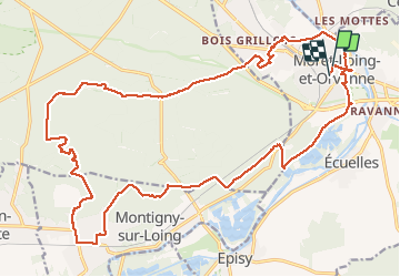
Trail Walking of 27 km to be discovered at Ile-de-France, Seine-et-Marne, Moret-Loing-et-Orvanne. This trail is proposed by chessyca.
Description
Superbe parcours mené par Jean Luc et Patrick avec des points de vues valant vraiment le détour, que ce soit en forêt ou en ville
Positioning
Country:
France
Region :
Ile-de-France
Department/Province :
Seine-et-Marne
Municipality :
Moret-Loing-et-Orvanne
Location:
Moret-sur-Loing
Start:(Dec)
Start:(UTM)
486272 ; 5357838 (31U) N.
Comments
Trails nearby
![Trail Walking Champagne-sur-Seine - GLM-150507 - Champagne - Photo](https://media.geolcdn.com/t/375/260/ext.jpg?maxdim=2&url=https%3A%2F%2Fservices.sitytrail.com%2FGeolivesWS%2FDownloadMedia.ashx%3FTrailID%3D417747%26Media%3Dcf3441e3-cd65-4b43-a868-e5ea57f18914.jpg)
![Walking Walking](https://static1.geolcdn.com/sitytour/trail-icons/101.png)
GLM-150507 - Champagne
Walking
Easy
(1)
Champagne-sur-Seine,
Ile-de-France,
Seine-et-Marne,
France
![](/images/other/stat-length.png)
17.3 km | 20 km-effort
4h 20min
![](https://static1.geolcdn.com/siteimages/upload/files/16400158638029165_repeat_loop_refresh_sync_direction_icon.png)
Yes
![Trail Walking Fontainebleau - Boucle 30 km Veni Venelles Vici - Photo](https://media.geolcdn.com/t/375/260/ext.jpg?maxdim=2&url=https%3A%2F%2Fstatic1.geolcdn.com%2Fsiteimages%2Fupload%2Ffiles%2F1553511878bg_sport_marche.png)
![Walking Walking](https://static1.geolcdn.com/sitytour/trail-icons/101.png)
Boucle 30 km Veni Venelles Vici
Walking
Very difficult
(1)
Fontainebleau,
Ile-de-France,
Seine-et-Marne,
France
![](/images/other/stat-length.png)
30 km | 35 km-effort
6h 0min
![](https://static1.geolcdn.com/siteimages/upload/files/16400158638029165_repeat_loop_refresh_sync_direction_icon.png)
No
![Trail Walking Fontainebleau - viennes carosses - Photo](https://media.geolcdn.com/t/375/260/9b54e644-4214-4411-b7b4-ea5a49e11005.jpg&format=jpg&maxdim=2)
![Walking Walking](https://static1.geolcdn.com/sitytour/trail-icons/101.png)
viennes carosses
Walking
Very easy
(2)
Fontainebleau,
Ile-de-France,
Seine-et-Marne,
France
![](/images/other/stat-length.png)
10.8 km | 14 km-effort
2h 50min
![](https://static1.geolcdn.com/siteimages/upload/files/16400158638029165_repeat_loop_refresh_sync_direction_icon.png)
Yes
![Trail Other activity Thomery - forêt de fontainebleau - Photo](https://media.geolcdn.com/t/375/260/ext.jpg?maxdim=2&url=https%3A%2F%2Fservices.sitytrail.com%2FGeolivesWS%2FDownloadMedia.ashx%3FTrailID%3D703736%26Media%3D20170223103030.jpg)
![Other activity Other activity](https://static1.geolcdn.com/sitytour/trail-icons/900.png)
forêt de fontainebleau
Other activity
Medium
(1)
Thomery,
Ile-de-France,
Seine-et-Marne,
France
![](/images/other/stat-length.png)
20 km | 23 km-effort
5h 40min
![](https://static1.geolcdn.com/siteimages/upload/files/16400158638029165_repeat_loop_refresh_sync_direction_icon.png)
Yes
![Trail Walking Fontainebleau - Boucle 30 km Thomery - Photo](https://media.geolcdn.com/t/375/260/0874c90c-8e55-44c8-845b-1a3f1ab9994c.jpg&format=jpg&maxdim=2)
![Walking Walking](https://static1.geolcdn.com/sitytour/trail-icons/101.png)
Boucle 30 km Thomery
Walking
Difficult
Fontainebleau,
Ile-de-France,
Seine-et-Marne,
France
![](/images/other/stat-length.png)
31 km | 36 km-effort
6h 8min
![](https://static1.geolcdn.com/siteimages/upload/files/16400158638029165_repeat_loop_refresh_sync_direction_icon.png)
Yes
![Trail Walking Champagne-sur-Seine - Boucle Champagne/ Seine - Moret - St Mammes - Thomery - Photo](https://media.geolcdn.com/t/375/260/a76c9969-6152-4085-be7d-0578611d1cc7.jpg&format=jpg&maxdim=2)
![Walking Walking](https://static1.geolcdn.com/sitytour/trail-icons/101.png)
Boucle Champagne/ Seine - Moret - St Mammes - Thomery
Walking
Easy
Champagne-sur-Seine,
Ile-de-France,
Seine-et-Marne,
France
![](/images/other/stat-length.png)
24 km | 27 km-effort
5h 15min
![](https://static1.geolcdn.com/siteimages/upload/files/16400158638029165_repeat_loop_refresh_sync_direction_icon.png)
Yes
![Trail On foot Moret-Loing-et-Orvanne - La basse vallée du Lunain version 30 km - Photo](https://media.geolcdn.com/t/375/260/7e9d55c6-78ba-44d4-861c-7056fde52aaa.jpg&format=jpg&maxdim=2)
![On foot On foot](https://static1.geolcdn.com/sitytour/trail-icons/100.png)
La basse vallée du Lunain version 30 km
On foot
Difficult
Moret-Loing-et-Orvanne,
Ile-de-France,
Seine-et-Marne,
France
![](/images/other/stat-length.png)
30 km | 34 km-effort
7h 39min
![](https://static1.geolcdn.com/siteimages/upload/files/16400158638029165_repeat_loop_refresh_sync_direction_icon.png)
Yes
![Trail On foot Fontainebleau - Sur les traces de Rosa Bonheur - Thomery - Photo](https://media.geolcdn.com/t/375/260/324d54be-66a3-49af-bf6e-2e2e4110383f.jpg&format=jpg&maxdim=2)
![On foot On foot](https://static1.geolcdn.com/sitytour/trail-icons/100.png)
Sur les traces de Rosa Bonheur - Thomery
On foot
Medium
Fontainebleau,
Ile-de-France,
Seine-et-Marne,
France
![](/images/other/stat-length.png)
30 km | 35 km-effort
7h 53min
![](https://static1.geolcdn.com/siteimages/upload/files/16400158638029165_repeat_loop_refresh_sync_direction_icon.png)
Yes
![Trail On foot Saint-Mammès - Batellerie et foret - Photo](https://media.geolcdn.com/t/375/260/51b649c2-1598-47b6-9a5e-d0492e6f7a35.jpeg&format=jpg&maxdim=2)
![On foot On foot](https://static1.geolcdn.com/sitytour/trail-icons/100.png)
Batellerie et foret
On foot
Easy
(1)
Saint-Mammès,
Ile-de-France,
Seine-et-Marne,
France
![](/images/other/stat-length.png)
8.6 km | 9.9 km-effort
2h 14min
![](https://static1.geolcdn.com/siteimages/upload/files/16400158638029165_repeat_loop_refresh_sync_direction_icon.png)
Yes