Trail Mountain bike Orpierre - Beaumont - Photo
© OpenStreetMap contributors
Length
Length
46 km
Max alt
Max alt
1461 m
Uphill gradient
Uphill gradient
1731 m
Km-Effort
Km-Effort  
69 km
Min alt
Min alt
598 m
Downhill gradient
Downhill gradient
1730 m
Boucle
Boucle
Yes
Creation date :
2019-02-25 19:45:36.997
Updated on :
2019-02-25 19:45:37.275

(0 Reviews)

Mountain bike
Mountain bike
4h18
Difficulty : Difficult

Scan this QR Code to open this trail in the SityTrail application

FREE GPS app for hiking

Logo SityTrail SityTrail

IGN / Geographical institutes

Download SityTrail from the App Store Download SityTrail from Google Play

Logo SityTrail SityTrail World

The world is yours!

Download SityTrail from the App Store Download SityTrail from Google Play Download SityTrail on Huawei AppGallery

About

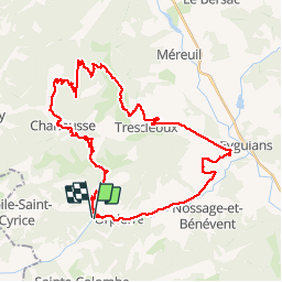
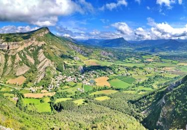
Trail Mountain bike of 46 km to be discovered at Provence-Alpes-Côte d'Azur, Hautes-Alpes, Orpierre. This trail is proposed by mzonzon05.

Description

Magnifique tour de VTT. Des difficultés à trouver le chemin au virage du sommet de charouille (bien guéter les fourrés sur la gauche !)
Nepas se tromper (comme moi) en montant au sommet de Beaumont ça rajoute de la distance pour rien. La descente par le GR est difficile et le GR n'est pas très bien entretenu hélas (éboulements non remis en état ...) penser à monter à Lagrand pour boire un coup et profiter de la vue (tant pis pour les cuisses !!) Pour éviter encore un peu la route on peut prendre le chemin noté sur l'IGN et correct entre les fermes Champ Jouvent et des Clots.

Elevation profile

Positioning

Country:
France
Region :
Provence-Alpes-Côte d'Azur
Department/Province :
Hautes-Alpes
Municipality :
Orpierre
Location:
Unknown
Start:(UTM)
713450 ; 4910227 (31T) N.

Trails nearby

Trail Walking Sainte-Colombe - st colombe la
Walking
margotte

Walking

Medium
Sainte-Colombe, Provence-Alpes-Côte d'Azur, Hautes-Alpes, France
11.6 km | 17.9 km-effort
3h 4min
Yes
Trail Walking Orpierre - rocher st Michel - Photo
Walking
margotte

Walking

Medium
Orpierre, Provence-Alpes-Côte d'Azur, Hautes-Alpes, France
9 km | 16 km-effort
3h 41min
Yes
Trail Walking Sainte-Colombe - catoyes  - Photo
Walking
céline BORLOZ

Walking

Very difficult
Sainte-Colombe, Provence-Alpes-Côte d'Azur, Hautes-Alpes, France
17 km | 27 km-effort
6h 26min
Yes
Trail Walking Sainte-Colombe - 100423 Plan de Cuques - Photo
Walking
mzonzon05

Walking

Difficult
Sainte-Colombe, Provence-Alpes-Côte d'Azur, Hautes-Alpes, France
11.7 km | 17.4 km-effort
3h 12min
No
Trail Walking Orpierre - 220822 La Louze - Photo
Walking
mzonzon05

Walking

Very difficult
Orpierre, Provence-Alpes-Côte d'Azur, Hautes-Alpes, France
12.5 km | 19.4 km-effort
2h 42min
Yes
Trail Walking Sainte-Colombe - SAINTE COLOMBE , les Bègues,  autour des versants du Céans o l - Photo
Walking
RobinMicheline

Walking

Medium
Sainte-Colombe, Provence-Alpes-Côte d'Azur, Hautes-Alpes, France
11.3 km | 17.3 km-effort
3h 9min
Yes
Trail Walking Trescléoux - Le Suillet via Le Rocher Pointu au Départ de Trescléoux - Photo
Walking
PapouBertrand

Walking

Very difficult
Trescléoux, Provence-Alpes-Côte d'Azur, Hautes-Alpes, France
13.2 km | 25 km-effort
6h 20min
Yes
Trail Walking Sainte-Colombe - SAINTE COLOMBE . 05 . Pas de Sainte  Colombe o m s - Photo
Walking
RobinMicheline

Walking

Medium
Sainte-Colombe, Provence-Alpes-Côte d'Azur, Hautes-Alpes, France
8 km | 13.3 km-effort
2h 56min
Yes
Trail Walking Trescléoux - TRESCLEOUX Les granges de la montagne o s  - Photo
Walking
RobinMicheline

Walking

Medium
(1)
Trescléoux, Provence-Alpes-Côte d'Azur, Hautes-Alpes, France
9.5 km | 16.6 km-effort
2h 54min
Yes


Close
My subscriptions