Trail Walking Trancault - Trancault rando linéaire - Photo

Trancault rando linéaire

© OpenStreetMap contributors
Length
Length
26 km
Max alt
Max alt
135 m
Uphill gradient
Uphill gradient
147 m
Km-Effort
Km-Effort  
28 km
Min alt
Min alt
87 m
Downhill gradient
Downhill gradient
116 m
Boucle
Boucle
No
Creation date :
2021-01-29 17:10:47.582
Updated on :
2021-01-29 17:11:48.607

(0 Reviews)

Walking
Walking
6h18
Difficulty : Very difficult

Scan this QR Code to open this trail in the SityTrail application

FREE GPS app for hiking

Logo SityTrail SityTrail

IGN / Geographical institutes

Download SityTrail from the App Store Download SityTrail from Google Play

Logo SityTrail SityTrail World

The world is yours!

Download SityTrail from the App Store Download SityTrail from Google Play Download SityTrail on Huawei AppGallery

About

Trail Walking of 26 km to be discovered at Grand Est, Aube, Trancault. This trail is proposed by Jean CORBERON.

Description

Parcours linéaire prévu en mars 2021

Elevation profile

Positioning

Country:
France
Region :
Grand Est
Department/Province :
Aube
Municipality :
Trancault
Location:
Unknown
Start:(UTM)
539800 ; 5357865 (31U) N.

Trails nearby

Trail Walking Saint-Maurice-aux-Riches-Hommes - Forêt de Vauluisant (Dolmens de Trainel + Grotte) - Photo
Walking
Daneel-89

Walking

Easy
(1)
Saint-Maurice-aux-Riches-Hommes, Bourgogne-Franche-Comté, Yonne, France
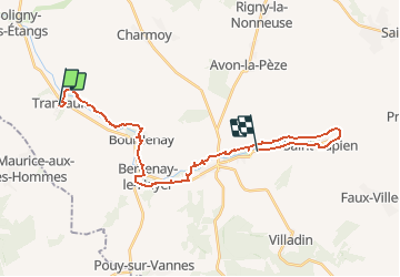
6.5 km | 8 km-effort
2h 0min
Yes
Trail Walking Saint-Maurice-aux-Riches-Hommes - forêt Vauluisant  - Photo
Walking
Domi1956

Walking

Very difficult
Saint-Maurice-aux-Riches-Hommes, Bourgogne-Franche-Comté, Yonne, France
17.3 km | 21 km-effort
5h 38min
Yes


Close
My subscriptions