Trail Walking Les Ulis - randonnée Philippe Della Santa  - Photo

randonnée Philippe Della Santa

© OpenStreetMap contributors
Length
Length
4.6 km
Max alt
Max alt
155 m
Uphill gradient
Uphill gradient
78 m
Km-Effort
Km-Effort  
5.4 km
Min alt
Min alt
95 m
Downhill gradient
Downhill gradient
22 m
Boucle
Boucle
No
Creation date :
2021-01-27 14:47:20.962
Updated on :
2021-01-27 19:24:39.787

(0 Reviews)

Walking
Walking
1h53
Difficulty : Very easy

Scan this QR Code to open this trail in the SityTrail application

FREE GPS app for hiking

Logo SityTrail SityTrail

IGN / Geographical institutes

Download SityTrail from the App Store Download SityTrail from Google Play

Logo SityTrail SityTrail World

The world is yours!

Download SityTrail from the App Store Download SityTrail from Google Play Download SityTrail on Huawei AppGallery

About

Trail Walking of 4.6 km to be discovered at Ile-de-France, Essonne, Les Ulis. This trail is proposed by Philippe Della Santa 2131 00 9.

Elevation profile

Positioning

Country:
France
Region :
Ile-de-France
Department/Province :
Essonne
Municipality :
Les Ulis
Location:
Unknown
Start:(UTM)
438594 ; 5393823 (31U) N.

Trails nearby

Trail Walking Gif-sur-Yvette - _Gif sur Yvette, une ville à la campagne - Photo
Walking
GUIDE+

Walking

Medium
(3)
Gif-sur-Yvette, Ile-de-France, Essonne, France
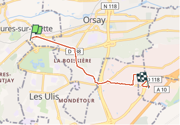
8.6 km | 10.5 km-effort
2h 0min
Yes
Trail Walking Palaiseau - De Lozere à Gif sur Yvette - Photo
Walking
tracegps

Walking

Medium
(1)
Palaiseau, Ile-de-France, Essonne, France
21 km | 28 km-effort
5h 0min
Yes
Trail Walking Gometz-le-Châtel - Autour de Gometz le Châtel - Photo
Walking
tracegps

Walking

Medium
(1)
Gometz-le-Châtel, Ile-de-France, Essonne, France
7.8 km | 10.6 km-effort
2h 30min
Yes
Trail Walking Bures-sur-Yvette - PR 9 Fauvettes - Photo
Walking
JacquesTB

Walking

Very easy
(1)
Bures-sur-Yvette, Ile-de-France, Essonne, France
6.6 km | 8.5 km-effort
2h 3min
Yes
Trail Walking Orsay - Le long de l yvette - Photo
Walking
philou91

Walking

Very easy
(1)
Orsay, Ile-de-France, Essonne, France
8.5 km | 9.4 km-effort
2h 43min
Yes
Trail Walking Orsay - Orsay Campus - Photo
Walking
tracegps

Walking

Medium
(1)
Orsay, Ile-de-France, Essonne, France
10.9 km | 13.3 km-effort
3h 30min
Yes
Trail Walking Igny - tour du plateau de Saclay V2 - Photo
Walking
Jean Pierre Parent

Walking

Very difficult
(1)
Igny, Ile-de-France, Essonne, France
21 km | 25 km-effort
5h 36min
Yes
Trail Walking Gometz-le-Châtel - Gometz-le-Chatel.11022024 - Photo
Walking
aucamus

Walking

Medium
(1)
Gometz-le-Châtel, Ile-de-France, Essonne, France
17.9 km | 24 km-effort
5h 28min
Yes
Trail Walking Gif-sur-Yvette - Boucle Gif Sur Yvette 20 km - 370 mètres dénivelés - Photo
Walking
GUIDE
chessyca

Walking

Easy
Gif-sur-Yvette, Ile-de-France, Essonne, France
21 km | 27 km-effort
5h 5min
Yes


Close
My subscriptions