![](/images/other/stat-length.png)
Boucle Peillon - Peille - St Martin de Peille
aris
User
![Length](/images/other/stat-length.png)
Length
15.2 km
![Max alt](https://static1.geolcdn.com/siteimages/upload/files/1508320355ic_sort_altitude_max_24dp.png)
Max alt
840 m
![Uphill gradient](https://static1.geolcdn.com/siteimages/upload/files/1508320355ic_sort_den_pos_24dp.png)
Uphill gradient
729 m
![Km-Effort](/images/other/stat-length.png)
Km-Effort
25 km
![Min alt](https://static1.geolcdn.com/siteimages/upload/files/1508320355ic_sort_altitude_min_24dp.png)
Min alt
351 m
![Downhill gradient](https://static1.geolcdn.com/siteimages/upload/files/1508320355ic_sort_den_neg_24dp.png)
Downhill gradient
731 m
![Boucle](https://static1.geolcdn.com/siteimages/upload/files/16400158638029165_repeat_loop_refresh_sync_direction_icon.png)
Boucle
Yes
Creation date :
2021-01-24 08:41:38.679
Updated on :
2021-01-25 12:53:26.485
![Walking](https://static1.geolcdn.com/sitytour/trail-icons/101.png)
7h31
Difficulty : Medium
![Scan this QR Code to open this trail in the SityTrail application](https://capi.geolives.com/qq0zvz2zws4bq2lad0pu/sitytour/trails/2650044/qr.png?size=200)
FREE GPS app for hiking
About
Trail Walking of 15.2 km to be discovered at Provence-Alpes-Côte d'Azur, Maritime Alps, Peillon. This trail is proposed by aris.
Description
Boucle au départ de Peillon. Trajet facile, belles vues sur les villages de Peille et Peillon, le Mt Agel. Et plus loin le Cheiron et le Mounier enneigés.
Positioning
Country:
France
Region :
Provence-Alpes-Côte d'Azur
Department/Province :
Maritime Alps
Municipality :
Peillon
Location:
Unknown
Start:(Dec)
Start:(UTM)
369735 ; 4848603 (32T) N.
Comments
Trails nearby
![Trail Walking Peillon - Via Alpina - R161: Peillon > Monaco - Place du Palais - Photo](https://media.geolcdn.com/t/375/260/ext.jpg?maxdim=2&url=https%3A%2F%2Fservices.sitytrail.com%2FGeolivesWS%2FDownloadMedia.ashx%3FTrailID%3D109722%26Media%3D4434_1.jpg)
![Walking Walking](https://static1.geolcdn.com/sitytour/trail-icons/101.png)
Via Alpina - R161: Peillon > Monaco - Place du Palais
Walking
Medium
(2)
Peillon,
Provence-Alpes-Côte d'Azur,
Maritime Alps,
France
![](/images/other/stat-length.png)
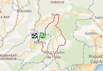
10.3 km | 16.7 km-effort
2h 49min
![](https://static1.geolcdn.com/siteimages/upload/files/16400158638029165_repeat_loop_refresh_sync_direction_icon.png)
No
![Trail Walking Cantaron - Cantaron : Monts Macaron et Ubac par Levens Tourette réelle - Photo](https://media.geolcdn.com/t/375/260/60da6868-ad90-4803-993b-f92b5b64ec1d.jpg&format=jpg&maxdim=2)
![Walking Walking](https://static1.geolcdn.com/sitytour/trail-icons/101.png)
Cantaron : Monts Macaron et Ubac par Levens Tourette réelle
Walking
Very difficult
Cantaron,
Provence-Alpes-Côte d'Azur,
Maritime Alps,
France
![](/images/other/stat-length.png)
19.7 km | 35 km-effort
7h 57min
![](https://static1.geolcdn.com/siteimages/upload/files/16400158638029165_repeat_loop_refresh_sync_direction_icon.png)
Yes
![Trail On foot Peille - Cime de Baudon - Photo](https://media.geolcdn.com/t/375/260/9fe230af-c31e-48d2-a797-a81c449946d4.jpeg&format=jpg&maxdim=2)
![On foot On foot](https://static1.geolcdn.com/sitytour/trail-icons/100.png)
Cime de Baudon
On foot
Easy
Peille,
Provence-Alpes-Côte d'Azur,
Maritime Alps,
France
![](/images/other/stat-length.png)
7 km | 14.7 km-effort
3h 20min
![](https://static1.geolcdn.com/siteimages/upload/files/16400158638029165_repeat_loop_refresh_sync_direction_icon.png)
Yes
![Trail Walking Gorbio - Gorbio-Circuit des Cabanelles 31-10-2016 - Photo](https://media.geolcdn.com/t/375/260/ext.jpg?maxdim=2&url=https%3A%2F%2Fstatic1.geolcdn.com%2Fsiteimages%2Fupload%2Ffiles%2F1553511878bg_sport_marche.png)
![Walking Walking](https://static1.geolcdn.com/sitytour/trail-icons/101.png)
Gorbio-Circuit des Cabanelles 31-10-2016
Walking
Medium
(1)
Gorbio,
Provence-Alpes-Côte d'Azur,
Maritime Alps,
France
![](/images/other/stat-length.png)
10.8 km | 21 km-effort
3h 51min
![](https://static1.geolcdn.com/siteimages/upload/files/16400158638029165_repeat_loop_refresh_sync_direction_icon.png)
Yes
![Trail Other activity La Turbie - fort de la Revere - Photo](https://media.geolcdn.com/t/375/260/ext.jpg?maxdim=2&url=https%3A%2F%2Fstatic1.geolcdn.com%2Fsiteimages%2Fupload%2Ffiles%2F1545311037marcheuse_200dpi.jpg)
![Other activity Other activity](https://static1.geolcdn.com/sitytour/trail-icons/900.png)
fort de la Revere
Other activity
Very easy
(1)
La Turbie,
Provence-Alpes-Côte d'Azur,
Maritime Alps,
France
![](/images/other/stat-length.png)
8.4 km | 12 km-effort
1h 37min
![](https://static1.geolcdn.com/siteimages/upload/files/16400158638029165_repeat_loop_refresh_sync_direction_icon.png)
Yes
![Trail Walking Èze - eze 221213 - Photo](https://media.geolcdn.com/t/375/260/ext.jpg?maxdim=2&url=https%3A%2F%2Fstatic1.geolcdn.com%2Fsiteimages%2Fupload%2Ffiles%2F1553511878bg_sport_marche.png)
![Walking Walking](https://static1.geolcdn.com/sitytour/trail-icons/101.png)
eze 221213
Walking
Medium
(1)
Èze,
Provence-Alpes-Côte d'Azur,
Maritime Alps,
France
![](/images/other/stat-length.png)
9.9 km | 14.7 km-effort
2h 4min
![](https://static1.geolcdn.com/siteimages/upload/files/16400158638029165_repeat_loop_refresh_sync_direction_icon.png)
Yes
![Trail Walking Peille - Cime de Baudon - Photo](https://media.geolcdn.com/t/375/260/ext.jpg?maxdim=2&url=https%3A%2F%2Fstatic1.geolcdn.com%2Fsiteimages%2Fupload%2Ffiles%2F1553511878bg_sport_marche.png)
![Walking Walking](https://static1.geolcdn.com/sitytour/trail-icons/101.png)
Cime de Baudon
Walking
Medium
(1)
Peille,
Provence-Alpes-Côte d'Azur,
Maritime Alps,
France
![](/images/other/stat-length.png)
7.8 km | 15.7 km-effort
4h 15min
![](https://static1.geolcdn.com/siteimages/upload/files/16400158638029165_repeat_loop_refresh_sync_direction_icon.png)
Yes
![Trail Walking La Turbie - fort de la Revère - Photo](https://media.geolcdn.com/t/375/260/36809e70-ffd8-40f7-a525-eff2dd28c3a4.jpg&format=jpg&maxdim=2)
![Walking Walking](https://static1.geolcdn.com/sitytour/trail-icons/101.png)
fort de la Revère
Walking
Easy
La Turbie,
Provence-Alpes-Côte d'Azur,
Maritime Alps,
France
![](/images/other/stat-length.png)
8.6 km | 12.4 km-effort
2h 41min
![](https://static1.geolcdn.com/siteimages/upload/files/16400158638029165_repeat_loop_refresh_sync_direction_icon.png)
Yes
![Trail sport Peillon - Haut de Peillln - Photo](https://media.geolcdn.com/t/375/260/c4005846-76a0-402e-9b7f-3e1d660015db.jpg&format=jpg&maxdim=2)
Haut de Peillln
sport
Very easy
Peillon,
Provence-Alpes-Côte d'Azur,
Maritime Alps,
France
![](/images/other/stat-length.png)
6.8 km | 10.2 km-effort
Unknown
![](https://static1.geolcdn.com/siteimages/upload/files/16400158638029165_repeat_loop_refresh_sync_direction_icon.png)
Yes