Trail On foot Servon - JC 18 - 19.87km - boissy saint leger - Servon Ouest - Photo

JC 18 - 19.87km - boissy saint leger - Servon Ouest

Club randonnées SERVON

© OpenStreetMap contributors
Length
Length
20 km
Max alt
Max alt
105 m
Uphill gradient
Uphill gradient
148 m
Km-Effort
Km-Effort  
22 km
Min alt
Min alt
64 m
Downhill gradient
Downhill gradient
150 m
Boucle
Boucle
Yes
Creation date :
2021-01-19 13:42:28.049
Updated on :
2023-10-10 16:32:02.226

(2 Reviews)

On foot
On foot
5h02
Difficulty : Difficult

Scan this QR Code to open this trail in the SityTrail application

FREE GPS app for hiking

Logo SityTrail SityTrail

IGN / Geographical institutes

Download SityTrail from the App Store Download SityTrail from Google Play

Logo SityTrail SityTrail World

The world is yours!

Download SityTrail from the App Store Download SityTrail from Google Play Download SityTrail on Huawei AppGallery

About

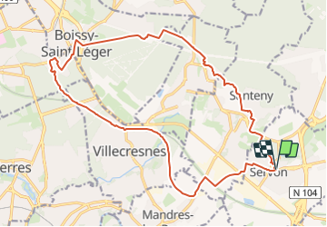
Trail On foot of 20 km to be discovered at Ile-de-France, Seine-et-Marne, Servon. This trail is proposed by Les 1000 pattes.

Description

Départ Mairie de Servon

Elevation profile

Positioning

Country:
France
Region :
Ile-de-France
Department/Province :
Seine-et-Marne
Municipality :
Servon
Location:
Unknown
Start:(UTM)
469738 ; 5395995 (31U) N.

Comments

Please log in to post a review or rate the element


Trails nearby

Trail On foot Marolles-en-Brie - L 48 Les Bagaudes et parcours sportif de Sucy 5,7 km - Photo
On foot

On foot

Easy
(5)
Marolles-en-Brie, Ile-de-France, Val-de-Marne, France
8.4 km | 9.2 km-effort
2h 5min
Yes
Trail On foot Lésigny - L 14 5.5 km boucle autour de L'orée de lésigny - Photo
On foot

On foot

Easy
(5)
Lésigny, Ile-de-France, Seine-et-Marne, France
8 km | 8.6 km-effort
1h 56min
Yes
Trail On foot Villecresnes - L 20  boucle golf villecresnes et ancienne voie de chemin de fer - Photo
On foot

On foot

Easy
(6)
Villecresnes, Ile-de-France, Val-de-Marne, France
7.7 km | 8.9 km-effort
2h 0min
Yes
Trail On foot Servon - nom_fic (49) - Photo
On foot

On foot

Easy
(6)
Servon, Ile-de-France, Seine-et-Marne, France
8.8 km | 9.9 km-effort
2h 14min
Yes
Trail Walking Boussy-Saint-Antoine - GRP CV-IDF 04 - Photo
Walking
clalaur

Walking

Difficult
(1)
Boussy-Saint-Antoine, Ile-de-France, Essonne, France
16.8 km | 18.6 km-effort
4h 13min
No
Trail Walking Marolles-en-Brie - GRP CV-IDF 05 - Photo
Walking
clalaur

Walking

Difficult
(1)
Marolles-en-Brie, Ile-de-France, Val-de-Marne, France
13.5 km | 15.2 km-effort
3h 27min
No
Trail Walking Mandres-les-Roses - J 26 Mandres, Boussy , Brunoy le chemin des fresques  - Photo
Walking

Walking

Medium
(2)
Mandres-les-Roses, Ile-de-France, Val-de-Marne, France
12.2 km | 13.8 km-effort
3h 7min
Yes
Trail On foot Servon - J 01  11.97 km  les 5 châteaux  - Photo
On foot

On foot

Medium
(1)
Servon, Ile-de-France, Seine-et-Marne, France
11.7 km | 13.2 km-effort
3h 3min
Yes
Trail On foot Servon - R 04 - 8 km -  Servon, Santeny, Servon - Photo
On foot

On foot

Very difficult
(4)
Servon, Ile-de-France, Seine-et-Marne, France
7.9 km | 9.1 km-effort
2h 3min
Yes


Close
My subscriptions