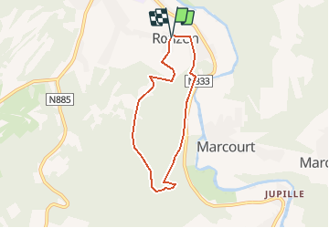
![](/images/other/stat-length.png)
![Trail Walking Rendeux - Montaigu - Photo](https://media.geolcdn.com/t/1900/400/ext.pjpeg?maxdim=2&url=https%3A%2F%2Fservices.sitytrail.com%2FGeolivesWS%2FDownloadMedia.ashx%3FTrailID%3D264121%26Media%3De6783db9-1bdf-46f4-876d-878e9e4b81fa.jpg)
Montaigu
RandoTFE
User
![Length](/images/other/stat-length.png)
Length
5.5 km
![Max alt](https://static1.geolcdn.com/siteimages/upload/files/1508320355ic_sort_altitude_max_24dp.png)
Max alt
394 m
![Uphill gradient](https://static1.geolcdn.com/siteimages/upload/files/1508320355ic_sort_den_pos_24dp.png)
Uphill gradient
183 m
![Km-Effort](/images/other/stat-length.png)
Km-Effort
8 km
![Min alt](https://static1.geolcdn.com/siteimages/upload/files/1508320355ic_sort_altitude_min_24dp.png)
Min alt
221 m
![Downhill gradient](https://static1.geolcdn.com/siteimages/upload/files/1508320355ic_sort_den_neg_24dp.png)
Downhill gradient
181 m
![Boucle](https://static1.geolcdn.com/siteimages/upload/files/16400158638029165_repeat_loop_refresh_sync_direction_icon.png)
Boucle
Yes
Creation date :
2014-12-10 00:00:00.0
Updated on :
2014-12-10 00:00:00.0
![Walking](https://static1.geolcdn.com/sitytour/trail-icons/101.png)
--
Difficulty : Easy
![Scan this QR Code to open this trail in the SityTrail application](https://capi.geolives.com/qq0zvz2zws4bq2lad0pu/sitytour/trails/264121/qr.png?size=200)
FREE GPS app for hiking
About
Trail Walking of 5.5 km to be discovered at Wallonia, Luxembourg, Rendeux. This trail is proposed by RandoTFE.
Description
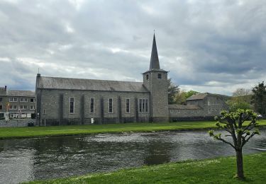
La Maison du Tourisme du Pays d'Ourthe et Aisne a le plaisir de vous présenter ce circuit thématique, orienté autour du culte de Saint Thibaut et de ses points de vue. Durant le parcours de ce dernier, vous les mystères qui habitent ce lieu emblématique.
Positioning
Country:
Belgium
Region :
Wallonia
Department/Province :
Luxembourg
Municipality :
Rendeux
Location:
Rendeux
Start:(Dec)
Start:(UTM)
679493 ; 5566999 (31U) N.
Comments
Trails nearby
![Trail Walking Érezée - rando amonines 26/10/2020 - Photo](https://media.geolcdn.com/t/375/260/1ff4a8e3-55b5-4447-9981-776e07faa610.jpg&format=jpg&maxdim=2)
![Walking Walking](https://static1.geolcdn.com/sitytour/trail-icons/101.png)
rando amonines 26/10/2020
Walking
Medium
(1)
Érezée,
Wallonia,
Luxembourg,
Belgium
![](/images/other/stat-length.png)
13.3 km | 18 km-effort
3h 2min
![](https://static1.geolcdn.com/siteimages/upload/files/16400158638029165_repeat_loop_refresh_sync_direction_icon.png)
Yes
![Trail Walking Rendeux - Arboretum et Ourthe - Photo](https://media.geolcdn.com/t/375/260/114fab54-a809-4035-a129-83d982caf499.jpg&format=jpg&maxdim=2)
![Walking Walking](https://static1.geolcdn.com/sitytour/trail-icons/101.png)
Arboretum et Ourthe
Walking
Medium
(4)
Rendeux,
Wallonia,
Luxembourg,
Belgium
![](/images/other/stat-length.png)
9 km | 12 km-effort
3h 15min
![](https://static1.geolcdn.com/siteimages/upload/files/16400158638029165_repeat_loop_refresh_sync_direction_icon.png)
Yes
![Trail Walking Rendeux - hodister - Photo](https://media.geolcdn.com/t/375/260/e73fbed5-6ae2-4bd7-8844-cc4756518ef2.jpg&format=jpg&maxdim=2)
![Walking Walking](https://static1.geolcdn.com/sitytour/trail-icons/101.png)
hodister
Walking
Easy
(1)
Rendeux,
Wallonia,
Luxembourg,
Belgium
![](/images/other/stat-length.png)
8.8 km | 11.5 km-effort
3h 39min
![](https://static1.geolcdn.com/siteimages/upload/files/16400158638029165_repeat_loop_refresh_sync_direction_icon.png)
Yes
![Trail Walking Rendeux - promenade de lourthe - Photo](https://media.geolcdn.com/t/375/260/ext.jpg?maxdim=2&url=https%3A%2F%2Fservices.sitytrail.com%2FGeolivesWS%2FDownloadMedia.ashx%3FTrailID%3D338833%26Media%3Dfix__20140824184151.jpg)
![Walking Walking](https://static1.geolcdn.com/sitytour/trail-icons/101.png)
promenade de lourthe
Walking
Difficult
(3)
Rendeux,
Wallonia,
Luxembourg,
Belgium
![](/images/other/stat-length.png)
8.1 km | 11 km-effort
2h 35min
![](https://static1.geolcdn.com/siteimages/upload/files/16400158638029165_repeat_loop_refresh_sync_direction_icon.png)
Yes
![Trail Walking Hotton - De werpin a werpin via Trinal - Photo](https://media.geolcdn.com/t/375/260/ext.jpg?maxdim=2&url=https%3A%2F%2Fservices.sitytrail.com%2FGeolivesWS%2FDownloadMedia.ashx%3FTrailID%3D225931%26Media%3Dfix__20131007161453.jpg)
![Walking Walking](https://static1.geolcdn.com/sitytour/trail-icons/101.png)
De werpin a werpin via Trinal
Walking
Easy
(1)
Hotton,
Wallonia,
Luxembourg,
Belgium
![](/images/other/stat-length.png)
9.3 km | 12.4 km-effort
2h 38min
![](https://static1.geolcdn.com/siteimages/upload/files/16400158638029165_repeat_loop_refresh_sync_direction_icon.png)
Yes
![Trail Walking Hotton - 20241015 - TOTEMUS HOTTON - 5.4 Km - Photo](https://media.geolcdn.com/t/375/260/d43cf3cd-7fde-4960-b7e9-583dcb543dfc.jpeg&format=jpg&maxdim=2)
![Walking Walking](https://static1.geolcdn.com/sitytour/trail-icons/101.png)
20241015 - TOTEMUS HOTTON - 5.4 Km
Walking
Medium
Hotton,
Wallonia,
Luxembourg,
Belgium
![](/images/other/stat-length.png)
5.4 km | 6.8 km-effort
2h 19min
![](https://static1.geolcdn.com/siteimages/upload/files/16400158638029165_repeat_loop_refresh_sync_direction_icon.png)
Yes
![Trail sport Hotton - 2024-07-29_09h57m47_gpxfile - Photo](https://media.geolcdn.com/t/375/260/ext.jpg?maxdim=2&url=https%3A%2F%2Fsecurestorage.geolives.com%2Fsitytour%2Ftrail-bg%2Fdefault.jpg)
2024-07-29_09h57m47_gpxfile
sport
Very easy
(1)
Hotton,
Wallonia,
Luxembourg,
Belgium
![](/images/other/stat-length.png)
9.3 km | 13 km-effort
Unknown
![](https://static1.geolcdn.com/siteimages/upload/files/16400158638029165_repeat_loop_refresh_sync_direction_icon.png)
Yes
![Trail Walking Hotton - Balade à Hotton - Photo](https://media.geolcdn.com/t/375/260/768efbbe-c567-45b1-bd57-69176b5f50b6.jpeg&format=jpg&maxdim=2)
![Walking Walking](https://static1.geolcdn.com/sitytour/trail-icons/101.png)
Balade à Hotton
Walking
Medium
Hotton,
Wallonia,
Luxembourg,
Belgium
![](/images/other/stat-length.png)
7.1 km | 8.9 km-effort
2h 0min
![](https://static1.geolcdn.com/siteimages/upload/files/16400158638029165_repeat_loop_refresh_sync_direction_icon.png)
No