![](/images/other/stat-length.png)
![Trail Walking Orban - Orban Sentier des Crêtes modifié. - Photo](https://media.geolcdn.com/t/1900/400/ext.pjpeg?maxdim=2&url=https%3A%2F%2Fstatic1.geolcdn.com%2Fsiteimages%2Fupload%2Ffiles%2F1553511878bg_sport_marche.png)
Orban Sentier des Crêtes modifié.
jpipacific
User
![Length](/images/other/stat-length.png)
Length
8.1 km
![Max alt](https://static1.geolcdn.com/siteimages/upload/files/1508320355ic_sort_altitude_max_24dp.png)
Max alt
249 m
![Uphill gradient](https://static1.geolcdn.com/siteimages/upload/files/1508320355ic_sort_den_pos_24dp.png)
Uphill gradient
154 m
![Km-Effort](/images/other/stat-length.png)
Km-Effort
10.1 km
![Min alt](https://static1.geolcdn.com/siteimages/upload/files/1508320355ic_sort_altitude_min_24dp.png)
Min alt
200 m
![Downhill gradient](https://static1.geolcdn.com/siteimages/upload/files/1508320355ic_sort_den_neg_24dp.png)
Downhill gradient
154 m
![Boucle](https://static1.geolcdn.com/siteimages/upload/files/16400158638029165_repeat_loop_refresh_sync_direction_icon.png)
Boucle
Yes
Creation date :
2021-01-13 09:36:17.382
Updated on :
2021-01-13 14:39:28.087
![Walking](https://static1.geolcdn.com/sitytour/trail-icons/101.png)
2h00
Difficulty : Easy
![Scan this QR Code to open this trail in the SityTrail application](https://capi.geolives.com/qq0zvz2zws4bq2lad0pu/sitytour/trails/2639802/qr.png?size=200)
FREE GPS app for hiking
About
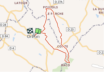
Trail Walking of 8.1 km to be discovered at Occitania, Tarn, Orban. This trail is proposed by jpipacific.
Description
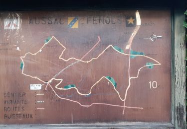
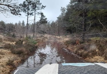
Sentier des crêtes modifié afin de ne pas passer au milieu de la ferme des Escrabins aux multiples chiens laissés en liberté et pas spécialement sympathiques.
Ce tracé est plus sécurisant et est bien agréable
Positioning
Country:
France
Region :
Occitania
Department/Province :
Tarn
Municipality :
Orban
Location:
Unknown
Start:(Dec)
Start:(UTM)
426304 ; 4854799 (31T) N.
Comments
Trails nearby
![Moto cross Moto cross](https://static1.geolcdn.com/sitytour/trail-icons/406.png)
Balade à Bozouls
Moto cross
Medium
Aussac,
Occitania,
Tarn,
France
![](/images/other/stat-length.png)
379 km | 465 km-effort
7h 37min
![](https://static1.geolcdn.com/siteimages/upload/files/16400158638029165_repeat_loop_refresh_sync_direction_icon.png)
No
![Walking Walking](https://static1.geolcdn.com/sitytour/trail-icons/101.png)
Pouzols chemin d'agros variante
Walking
Medium
Poulan-Pouzols,
Occitania,
Tarn,
France
![](/images/other/stat-length.png)
7.9 km | 9.3 km-effort
2h 0min
![](https://static1.geolcdn.com/siteimages/upload/files/16400158638029165_repeat_loop_refresh_sync_direction_icon.png)
Yes
![Trail Moto cross Fénols - La route des seigneurs et chateaux Aveyronnais - Photo](https://media.geolcdn.com/t/375/260/cc55bc8b-c631-4d92-a303-1c1fc25e23b1.jpg&format=jpg&maxdim=2)
![Moto cross Moto cross](https://static1.geolcdn.com/sitytour/trail-icons/406.png)
La route des seigneurs et chateaux Aveyronnais
Moto cross
Easy
Fénols,
Occitania,
Tarn,
France
![](/images/other/stat-length.png)
269 km | 328 km-effort
7h 0min
![](https://static1.geolcdn.com/siteimages/upload/files/16400158638029165_repeat_loop_refresh_sync_direction_icon.png)
Yes
![Trail Walking Orban - SityTrail - 3061378 - orban-chemin-des-cretes - Photo](https://media.geolcdn.com/t/375/260/26a0c344-fd25-47d2-a26d-446f19e423e5.jpg&format=jpg&maxdim=2)
![Walking Walking](https://static1.geolcdn.com/sitytour/trail-icons/101.png)
SityTrail - 3061378 - orban-chemin-des-cretes
Walking
Medium
Orban,
Occitania,
Tarn,
France
![](/images/other/stat-length.png)
5.9 km | 7.5 km-effort
1h 42min
![](https://static1.geolcdn.com/siteimages/upload/files/16400158638029165_repeat_loop_refresh_sync_direction_icon.png)
Yes
![Trail 4x4 Fénols - Vabre Anglés Parc du haut Languedoc - Photo](https://media.geolcdn.com/t/375/260/efe61901-ab29-4794-b72e-2a76a5d8cb95.jpeg&format=jpg&maxdim=2)
![4x4 4x4](https://static1.geolcdn.com/sitytour/trail-icons/403.png)
Vabre Anglés Parc du haut Languedoc
4x4
Medium
Fénols,
Occitania,
Tarn,
France
![](/images/other/stat-length.png)
181 km | 243 km-effort
7h 43min
![](https://static1.geolcdn.com/siteimages/upload/files/16400158638029165_repeat_loop_refresh_sync_direction_icon.png)
No
![Trail Mountain bike Rouffiac - Circuit du Puech de Mourens - Rouffiac - Photo](https://media.geolcdn.com/t/375/260/ext.jpg?maxdim=2&url=https%3A%2F%2Fservices.sitytrail.com%2FGeolivesWS%2FDownloadMedia.ashx%3FTrailID%3D104295%26Media%3D7522_3.jpg)
![Mountain bike Mountain bike](https://static1.geolcdn.com/sitytour/trail-icons/202.png)
Circuit du Puech de Mourens - Rouffiac
Mountain bike
Easy
Rouffiac,
Occitania,
Tarn,
France
![](/images/other/stat-length.png)
9.5 km | 11.8 km-effort
45min
![](https://static1.geolcdn.com/siteimages/upload/files/16400158638029165_repeat_loop_refresh_sync_direction_icon.png)
Yes
![Trail Walking Rouffiac - Circuit du Puech de Mourens - Rouffiac - Photo](https://media.geolcdn.com/t/375/260/ext.jpg?maxdim=2&url=https%3A%2F%2Fservices.sitytrail.com%2FGeolivesWS%2FDownloadMedia.ashx%3FTrailID%3D104294%26Media%3D7522_3.jpg)
![Walking Walking](https://static1.geolcdn.com/sitytour/trail-icons/101.png)
Circuit du Puech de Mourens - Rouffiac
Walking
Medium
(1)
Rouffiac,
Occitania,
Tarn,
France
![](/images/other/stat-length.png)
9.5 km | 11.8 km-effort
2h 19min
![](https://static1.geolcdn.com/siteimages/upload/files/16400158638029165_repeat_loop_refresh_sync_direction_icon.png)
Yes
![Walking Walking](https://static1.geolcdn.com/sitytour/trail-icons/101.png)
La Martinié Aussac Fenols
Walking
Easy
Aussac,
Occitania,
Tarn,
France
![](/images/other/stat-length.png)
7.8 km | 9.5 km-effort
2h 9min
![](https://static1.geolcdn.com/siteimages/upload/files/16400158638029165_repeat_loop_refresh_sync_direction_icon.png)
Yes
![Trail Walking Aussac - Aussac Fenols - Photo](https://media.geolcdn.com/t/375/260/7e85484a-811f-4fa2-9f42-bd4ceb8f983c.jpg&format=jpg&maxdim=2)
![Walking Walking](https://static1.geolcdn.com/sitytour/trail-icons/101.png)