![](/images/other/stat-length.png)
![Trail Walking Welkenraedt - Henri-Chapelle - La Clouse - Cimetière Américain - Gulpen - Bois de Hees - Photo](https://media.geolcdn.com/t/1900/400/ext.pjpeg?maxdim=2&url=https%3A%2F%2Fstatic1.geolcdn.com%2Fsiteimages%2Fupload%2Ffiles%2F1553511878bg_sport_marche.png)
Henri-Chapelle - La Clouse - Cimetière Américain - Gulpen - Bois de Hees
emoreau
User
![Length](/images/other/stat-length.png)
Length
11.2 km
![Max alt](https://static1.geolcdn.com/siteimages/upload/files/1508320355ic_sort_altitude_max_24dp.png)
Max alt
353 m
![Uphill gradient](https://static1.geolcdn.com/siteimages/upload/files/1508320355ic_sort_den_pos_24dp.png)
Uphill gradient
203 m
![Km-Effort](/images/other/stat-length.png)
Km-Effort
13.9 km
![Min alt](https://static1.geolcdn.com/siteimages/upload/files/1508320355ic_sort_altitude_min_24dp.png)
Min alt
254 m
![Downhill gradient](https://static1.geolcdn.com/siteimages/upload/files/1508320355ic_sort_den_neg_24dp.png)
Downhill gradient
202 m
![Boucle](https://static1.geolcdn.com/siteimages/upload/files/16400158638029165_repeat_loop_refresh_sync_direction_icon.png)
Boucle
Yes
Creation date :
2021-01-10 12:42:12.074
Updated on :
2021-01-11 19:56:28.666
![Walking](https://static1.geolcdn.com/sitytour/trail-icons/101.png)
3h46
Difficulty : Very easy
![Scan this QR Code to open this trail in the SityTrail application](https://capi.geolives.com/qq0zvz2zws4bq2lad0pu/sitytour/trails/2638658/qr.png?size=200)
FREE GPS app for hiking
About
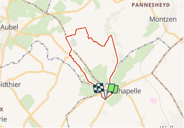
Trail Walking of 11.2 km to be discovered at Wallonia, Liège, Welkenraedt. This trail is proposed by emoreau.
Description
Belle promenade avec panorama sur le pays de Herve, visite du cimetière Américain de Henri-Chapelle, descente sur la vallée de la Gulpen puis retour en suivant la lisière du bois de Hees.
Positioning
Country:
Belgium
Region :
Wallonia
Department/Province :
Liège
Municipality :
Welkenraedt
Location:
Henri-Chapelle
Start:(Dec)
Start:(UTM)
706574 ; 5617553 (31U) N.
Comments
Trails nearby
![Trail Walking Thimister-Clermont - Froidthier - Photo](https://media.geolcdn.com/t/375/260/ext.jpg?maxdim=2&url=https%3A%2F%2Fmedia.geolcdn.com%2Ff%2F9142f7fe-feb5-4533-8005-65992f1c4338.jpg)
![Walking Walking](https://static1.geolcdn.com/sitytour/trail-icons/101.png)
Froidthier
Walking
Easy
(1)
Thimister-Clermont,
Wallonia,
Liège,
Belgium
![](/images/other/stat-length.png)
6.6 km | 7.9 km-effort
1h 48min
![](https://static1.geolcdn.com/siteimages/upload/files/16400158638029165_repeat_loop_refresh_sync_direction_icon.png)
Yes
![Trail Walking Baelen - Baelen - Eupen 🎄🎅 - Membach - Photo](https://media.geolcdn.com/t/375/260/ext.jpg?maxdim=2&url=https%3A%2F%2Fmedia.geolcdn.com%2Ff%2Fd50227a7-424d-470e-90d5-87ebd384de36.jpg)
![Walking Walking](https://static1.geolcdn.com/sitytour/trail-icons/101.png)
Baelen - Eupen 🎄🎅 - Membach
Walking
Easy
(1)
Baelen,
Wallonia,
Liège,
Belgium
![](/images/other/stat-length.png)
13.3 km | 15.6 km-effort
3h 32min
![](https://static1.geolcdn.com/siteimages/upload/files/16400158638029165_repeat_loop_refresh_sync_direction_icon.png)
Yes
![Trail Walking Plombières - 20220428 - Bois de Hess 6.7 Km - Photo](https://media.geolcdn.com/t/375/260/ext.jpg?maxdim=2&url=https%3A%2F%2Fmedia.geolcdn.com%2Ff%2Fa5b9728a-379a-44f7-9b32-760730404ded.JPG)
![Walking Walking](https://static1.geolcdn.com/sitytour/trail-icons/101.png)
20220428 - Bois de Hess 6.7 Km
Walking
Medium
(1)
Plombières,
Wallonia,
Liège,
Belgium
![](/images/other/stat-length.png)
6.7 km | 8.4 km-effort
3h 11min
![](https://static1.geolcdn.com/siteimages/upload/files/16400158638029165_repeat_loop_refresh_sync_direction_icon.png)
Yes
![Trail Walking Lontzen - 2021-05-03_18h55m44_herbesthal - Photo](https://media.geolcdn.com/t/375/260/ext.jpg?maxdim=2&url=https%3A%2F%2Fmedia.geolcdn.com%2Ff%2Ff329bf39-b33b-4890-a8af-1e7d956ba015.jpg)
![Walking Walking](https://static1.geolcdn.com/sitytour/trail-icons/101.png)
2021-05-03_18h55m44_herbesthal
Walking
Easy
(2)
Lontzen,
Wallonia,
Liège,
Belgium
![](/images/other/stat-length.png)
13.4 km | 15.8 km-effort
3h 35min
![](https://static1.geolcdn.com/siteimages/upload/files/16400158638029165_repeat_loop_refresh_sync_direction_icon.png)
Yes
![Trail Walking Aubel - RB-Lg-04 - Raccourci - À travers le bocage aubelois - Photo](https://media.geolcdn.com/t/375/260/ext.jpg?maxdim=2&url=https%3A%2F%2Fservices.sitytrail.com%2FGeolivesWS%2FDownloadMedia.ashx%3FTrailID%3D209393%26Media%3D9ac6c0af-9a08-4948-b5d5-06a09e8ba132.jpg)
![Walking Walking](https://static1.geolcdn.com/sitytour/trail-icons/101.png)
RB-Lg-04 - Raccourci - À travers le bocage aubelois
Walking
Medium
(3)
Aubel,
Wallonia,
Liège,
Belgium
![](/images/other/stat-length.png)
17.1 km | 22 km-effort
4h 50min
![](https://static1.geolcdn.com/siteimages/upload/files/16400158638029165_repeat_loop_refresh_sync_direction_icon.png)
Yes
![Trail Mountain bike Aubel - 10942068-VTT AUBEL 10 MAI 2020 58 KMS - Photo](https://media.geolcdn.com/t/375/260/ext.jpg?maxdim=2&url=https%3A%2F%2Fmedia.geolcdn.com%2Ff%2Fdb368aa7-ef51-4c2a-90d2-a8cae2117bc2.jpg)
![Mountain bike Mountain bike](https://static1.geolcdn.com/sitytour/trail-icons/202.png)
10942068-VTT AUBEL 10 MAI 2020 58 KMS
Mountain bike
Very difficult
(2)
Aubel,
Wallonia,
Liège,
Belgium
![](/images/other/stat-length.png)
42 km | 55 km-effort
5h 8min
![](https://static1.geolcdn.com/siteimages/upload/files/16400158638029165_repeat_loop_refresh_sync_direction_icon.png)
Yes
![Trail Walking Aubel - Aubel, Tossem, Helestrop - Photo](https://media.geolcdn.com/t/375/260/ext.jpg?maxdim=2&url=https%3A%2F%2Fservices.sitytrail.com%2FGeolivesWS%2FDownloadMedia.ashx%3FTrailID%3D643850%26Media%3D20161009164230.jpg)
![Walking Walking](https://static1.geolcdn.com/sitytour/trail-icons/101.png)
Aubel, Tossem, Helestrop
Walking
Very easy
(1)
Aubel,
Wallonia,
Liège,
Belgium
![](/images/other/stat-length.png)
9.9 km | 12 km-effort
2h 44min
![](https://static1.geolcdn.com/siteimages/upload/files/16400158638029165_repeat_loop_refresh_sync_direction_icon.png)
Yes
![Trail Walking Welkenraedt - Promenade des deux Châteaux (5km) - Photo](https://media.geolcdn.com/t/375/260/ext.jpg?maxdim=2&url=https%3A%2F%2Fstatic1.geolcdn.com%2Fsiteimages%2Fupload%2Ffiles%2F1553511878bg_sport_marche.png)
![Walking Walking](https://static1.geolcdn.com/sitytour/trail-icons/101.png)
Promenade des deux Châteaux (5km)
Walking
Very easy
(2)
Welkenraedt,
Wallonia,
Liège,
Belgium
![](/images/other/stat-length.png)
5.4 km | 6 km-effort
Unknown
![](https://static1.geolcdn.com/siteimages/upload/files/16400158638029165_repeat_loop_refresh_sync_direction_icon.png)
Yes
![Trail Walking Thimister-Clermont - 12km froidthier crawhez oct23 à faire - Photo](https://media.geolcdn.com/t/375/260/ext.jpg?maxdim=2&url=https%3A%2F%2Fstatic1.geolcdn.com%2Fsiteimages%2Fupload%2Ffiles%2F1553511878bg_sport_marche.png)
![Walking Walking](https://static1.geolcdn.com/sitytour/trail-icons/101.png)
12km froidthier crawhez oct23 à faire
Walking
Difficult
(1)
Thimister-Clermont,
Wallonia,
Liège,
Belgium
![](/images/other/stat-length.png)
11.9 km | 14.4 km-effort
3h 17min
![](https://static1.geolcdn.com/siteimages/upload/files/16400158638029165_repeat_loop_refresh_sync_direction_icon.png)
Yes