Trail On foot Drap - 12425242-track-1610378986-622 - Photo

12425242-track-1610378986-622

 Renefrt
Renefrt

User

© OpenStreetMap contributors
Length
Length
8.8 km
Max alt
Max alt
552 m
Uphill gradient
Uphill gradient
394 m
Km-Effort
Km-Effort  
14 km
Min alt
Min alt
274 m
Downhill gradient
Downhill gradient
394 m
Boucle
Boucle
Yes
Creation date :
2021-01-11 15:30:08.0
Updated on :
2021-01-18 11:08:08.346

(0 Reviews)

On foot
On foot
--
Difficulty : Medium

Scan this QR Code to open this trail in the SityTrail application

FREE GPS app for hiking

Logo SityTrail SityTrail

IGN / Geographical institutes

Download SityTrail from the App Store Download SityTrail from Google Play

Logo SityTrail SityTrail World

The world is yours!

Download SityTrail from the App Store Download SityTrail from Google Play Download SityTrail on Huawei AppGallery

About

Trail On foot of 8.8 km to be discovered at Provence-Alpes-Côte d'Azur, Maritime Alps, Drap. This trail is proposed by Renefrt.

Description

Le kilometrage me semble pas bon je dirais plus 11 Km.
Peut se faire au départ de Laghet.

Elevation profile

Positioning

Country:
France
Region :
Provence-Alpes-Côte d'Azur
Department/Province :
Maritime Alps
Municipality :
Drap
Location:
Unknown
Start:(Dec)
Start:(UTM)
366635 ; 4845661 (32T) N.

Trails nearby

Trail Walking Peillon - Via Alpina - R161: Peillon > Monaco - Place du Palais - Photo
Walking
tracegps

Walking

Medium
(2)
Peillon, Provence-Alpes-Côte d'Azur, Maritime Alps, France
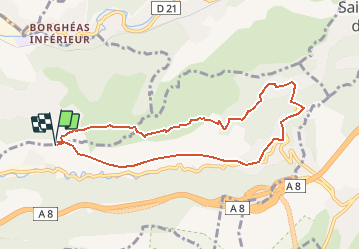
10.3 km | 16.7 km-effort
2h 49min
No
Trail Walking Cantaron - Cantaron : Monts Macaron et Ubac  par Levens Tourette réelle - Photo
Walking
GUIDE
jouans

Walking

Very difficult
Cantaron, Provence-Alpes-Côte d'Azur, Maritime Alps, France
19.7 km | 35 km-effort
7h 57min
Yes
Trail Walking Cap-d'Ail - Nice Cap d'Ail en train et retour par les cretes - Photo
Walking
GUIDE
jouans

Walking

Very difficult
Cap-d'Ail, Provence-Alpes-Côte d'Azur, Maritime Alps, France
23 km | 36 km-effort
8h 6min
No
Trail On foot Èze - Circuit du mont Bastide - Photo
On foot
GUIDE+

On foot

Easy
Èze, Provence-Alpes-Côte d'Azur, Maritime Alps, France
7 km | 14.7 km-effort
3h 20min
Yes
Trail Walking Èze - Mont Bastide, sentier de Nietzsche - Photo
Walking
PEBREJOSIANE

Walking

Easy
(1)
Èze, Provence-Alpes-Côte d'Azur, Maritime Alps, France
7.2 km | 15.1 km-effort
3h 15min
Yes
Trail Other activity La Turbie - fort de la Revere  - Photo
Other activity
juleyann

Other activity

Very easy
(1)
La Turbie, Provence-Alpes-Côte d'Azur, Maritime Alps, France
8.4 km | 12 km-effort
1h 37min
Yes
Trail Walking Èze - eze 221213 - Photo
Walking
legios84

Walking

Medium
(1)
Èze, Provence-Alpes-Côte d'Azur, Maritime Alps, France
9.9 km | 14.7 km-effort
2h 4min
Yes
Trail Walking Cap-d'Ail - 06 cap d ail tête de 🐕 01.06.24 - Photo
Walking
GUIDE
randodyssée

Walking

Medium
Cap-d'Ail, Provence-Alpes-Côte d'Azur, Maritime Alps, France
15.3 km | 24 km-effort
6h 55min
Yes
Trail sport Peillon - Haut de Peillln - Photo
sport
jwo47

sport

Very easy
Peillon, Provence-Alpes-Côte d'Azur, Maritime Alps, France
6.8 km | 10.2 km-effort
Unknown
Yes


Close
My subscriptions