Trail Walking Nailhac - Chassaignas La Chapelle St Jean 12km - Photo

Chassaignas La Chapelle St Jean 12km

 YV24
YV24

User

© OpenStreetMap contributors
Length
Length
11.9 km
Max alt
Max alt
352 m
Uphill gradient
Uphill gradient
246 m
Km-Effort
Km-Effort  
15.2 km
Min alt
Min alt
239 m
Downhill gradient
Downhill gradient
241 m
Boucle
Boucle
Yes
Creation date :
2014-12-10 00:00:00.0
Updated on :
2014-12-10 00:00:00.0

(0 Reviews)

Walking
Walking
3h16
Difficulty : Easy

Scan this QR Code to open this trail in the SityTrail application

FREE GPS app for hiking

Logo SityTrail SityTrail

IGN / Geographical institutes

Download SityTrail from the App Store Download SityTrail from Google Play

Logo SityTrail SityTrail World

The world is yours!

Download SityTrail from the App Store Download SityTrail from Google Play Download SityTrail on Huawei AppGallery

About

Trail Walking of 11.9 km to be discovered at New Aquitaine, Dordogne, Nailhac. This trail is proposed by YV24.

Description

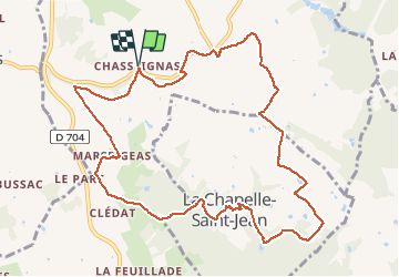
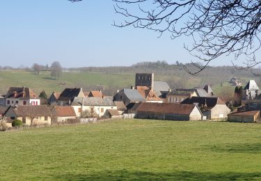
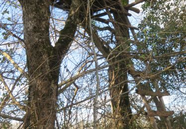
PDIP boucle de la Chapelle St Jean AU DEPART du lieu dit de Chassaignas ou (Chasseignas, suivant les cartes)Avril 2014 : Bien tracée et panneautée, qqs rares balises manquantes, Vallonnée, variée, agréable. Pas mal d'ornières : à éviter après des pluies intenses ou durables. Belles vues et maisons restaurées.

Elevation profile

Positioning

Country:
France
Region :
New Aquitaine
Department/Province :
Dordogne
Municipality :
Nailhac
Location:
Unknown
Start:(UTM)
354582 ; 5007970 (31T) N.

Trails nearby

Trail Walking Nailhac - Boucle de Nailhac  - Photo
Walking
swp648

Walking

Easy
Nailhac, New Aquitaine, Dordogne, France
11.7 km | 14.9 km-effort
2h 54min
Yes
Trail Walking Granges-d'Ans - Paysage et nature depuis Granges-d’Ans - Photo
Walking
houbart

Walking

Difficult
Granges-d'Ans, New Aquitaine, Dordogne, France
11.8 km | 15 km-effort
3h 24min
Yes
Trail Mountain bike La Chapelle-Saint-Jean - La Chapelle Saint Jean - Photo
Mountain bike
heyoka

Mountain bike

Easy
La Chapelle-Saint-Jean, New Aquitaine, Dordogne, France
11.7 km | 14.7 km-effort
3h 20min
No
Trail Walking Granges-d'Ans - track - Photo
Walking
swp648

Walking

Difficult
Granges-d'Ans, New Aquitaine, Dordogne, France
11 km | 14 km-effort
3h 11min
Yes
Trail Mountain bike La Chapelle-Saint-Jean - 2 - Photo
Mountain bike
christophe binet

Mountain bike

Very difficult
La Chapelle-Saint-Jean, New Aquitaine, Dordogne, France
41 km | 52 km-effort
1h 47min
No
Trail Walking Châtres - boucle chatres - Photo
Walking
fab0202

Walking

Easy
(1)
Châtres, New Aquitaine, Dordogne, France
10.9 km | 14.7 km-effort
2h 42min
Yes
Trail On foot Nailhac - Nailhac Noix allongée 11km - Photo
On foot
YV24

On foot

Easy
(2)
Nailhac, New Aquitaine, Dordogne, France
11.1 km | 14.2 km-effort
Unknown
Yes
Trail Walking Saint-Rabier - chateau coderc - Photo
Walking
personono

Walking

Easy
Saint-Rabier, New Aquitaine, Dordogne, France
7.1 km | 9 km-effort
1h 52min
Yes
Trail Walking Saint-Rabier - Gd Coderc Grange d'Ans 12 km - Photo
Walking
YV24

Walking

Easy
Saint-Rabier, New Aquitaine, Dordogne, France
11.7 km | 15.5 km-effort
3h 18min
Yes


Close
My subscriptions