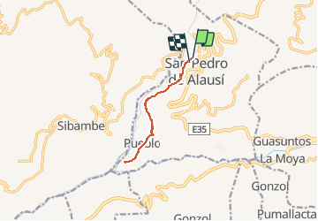
Trail Walking Alausí - Nariz del diablo - Photo

Nariz del diablo

 gildascb
gildascb

User

© OpenStreetMap contributors
Length
Length
13.5 km
Max alt
Max alt
2349 m
Uphill gradient
Uphill gradient
542 m
Km-Effort
Km-Effort  
21 km
Min alt
Min alt
2186 m
Downhill gradient
Downhill gradient
548 m
Boucle
Boucle
No
Creation date :
2021-01-01 13:56:59.168
Updated on :
2021-02-22 03:11:33.065

(0 Reviews)

Walking
Walking
4h29
Difficulty : Medium

Scan this QR Code to open this trail in the SityTrail application

FREE GPS app for hiking

Logo SityTrail SityTrail

IGN / Geographical institutes

Download SityTrail from the App Store Download SityTrail from Google Play

Logo SityTrail SityTrail World

The world is yours!

Download SityTrail from the App Store Download SityTrail from Google Play Download SityTrail on Huawei AppGallery

About

Trail Walking of 13.5 km to be discovered at Chimborazo, Alausí, Alausí. This trail is proposed by gildascb.

Description

Saliendo del "Community Hostel" de Alausí, esta caminata atraviesa la ciudad y llega al extremo de Nariz del Diablo. Absolutamente preciosa.

Puntos de vistas espectaculares, particularmente cuando llegamos a la "Nariz del Diablo" sobre el valle abajo. Estatua de un Condor.

Elevation profile

Photos

Positioning

Country:
Ecuador
Region :
Chimborazo
Department/Province :
Alausí
Municipality :
Alausí
Location:
Unknown
Start:(UTM)
739472 ; 9756617 (17M) S.

Trails nearby


Close
My subscriptions