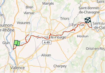
![](/images/other/stat-length.png)
![Trail Cycle Châteauneuf-sur-Isère - Cirkwi-VVV_de_la_Vallée_de_l_Isère - Photo](https://media.geolcdn.com/t/1900/400/ext.pjpeg?maxdim=2&url=https%3A%2F%2Fstatic1.geolcdn.com%2Fsiteimages%2Fupload%2Ffiles%2F1524743154velo.jpg)
Cirkwi-VVV_de_la_Vallée_de_l_Isère
JackyCouturier
User
![Length](/images/other/stat-length.png)
![Max alt](https://static1.geolcdn.com/siteimages/upload/files/1508320355ic_sort_altitude_max_24dp.png)
![Uphill gradient](https://static1.geolcdn.com/siteimages/upload/files/1508320355ic_sort_den_pos_24dp.png)
![Km-Effort](/images/other/stat-length.png)
![Min alt](https://static1.geolcdn.com/siteimages/upload/files/1508320355ic_sort_altitude_min_24dp.png)
![Downhill gradient](https://static1.geolcdn.com/siteimages/upload/files/1508320355ic_sort_den_neg_24dp.png)
![Boucle](https://static1.geolcdn.com/siteimages/upload/files/16400158638029165_repeat_loop_refresh_sync_direction_icon.png)
![Cycle](https://static1.geolcdn.com/sitytour/trail-icons/200.png)
--
Difficulty : Unknown
![Scan this QR Code to open this trail in the SityTrail application](https://capi.geolives.com/qq0zvz2zws4bq2lad0pu/sitytour/trails/2628998/qr.png?size=200)
FREE GPS app for hiking
About
Trail Cycle of 52 km to be discovered at Auvergne-Rhône-Alpes, Drôme, Châteauneuf-sur-Isère. This trail is proposed by JackyCouturier.
Description
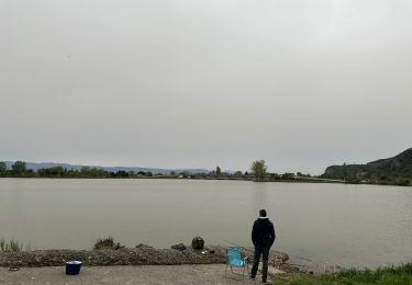
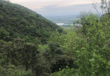
Véloroute Voie Verte qui reliera la Haute-Savoie à la Drôme. Au départ de St Nazaire-en-Royans, 42 kilomètres traversent la Drôme des Collines avant de rejoindre le Rhône et la ViaRhôna, au lieu dit le Saut des chèvres à Châteauneuf-sur-Isère. Elle est inscrite au schéma national des véloroutes et voies vertes (itinéraire V63). En sortie sportive ou familiale, la VVV s’adresse aux marcheurs, aux cyclistes, aux rollers et sur certaines parties, aux randonneurs à chevaux. Le parcours alterne entre véloroutes, portions partagées avec les véhicules motorisés, et voies vertes, pistes réservées aux modes de déplacements doux. En plus des voies longeant l’Isère, trois passerelles sont construites pour franchir la rivière et circuler d’une rive à l’autre... Celles de Bourg de Péage/Romans-sur-Isère et du Port d’Ouvey entre Saint Paul-lès-Romans et Eymeux sont déjà praticables. La dernière à La Vanelle, entre Châteauneuf-sur-Isère et Granges-lès-Beaumont, s'achève. Le 17 novembre 2013, le Département de la Drôme inaugure officiellement la VVV VI avec l'organisation d'une grande journée festive pour l'itinéraire drômois. Ces ouvrages métalliques d’une portée totale de 152 mètres et d’une largeur de voie de 3,50 mètres, seront ouverts aux piétons, aux deux-roues non motorisés et aux cavaliers, pied à terre pour passer de l’une à l’autre des rives de l’Isère. Pour le tracé, l'itinéraire drômois passe par Saint-Nazaire-en-Royans, la Baume-d'Hostun, Eymeux, St-Paul-les-Romans, Bourg-de-Péage, Romans, Granges-les-Beaumont et Châteauneuf-sur-Isère.
Positioning
Comments
Trails nearby
![Trail Walking Cornas - De Cornas à la Borne - Photo](https://media.geolcdn.com/t/375/260/ext.jpg?maxdim=2&url=https%3A%2F%2Fstatic1.geolcdn.com%2Fsiteimages%2Fupload%2Ffiles%2F1553511878bg_sport_marche.png)
![Walking Walking](https://static1.geolcdn.com/sitytour/trail-icons/101.png)
Walking
![](/images/other/stat-length.png)
![](https://static1.geolcdn.com/siteimages/upload/files/16400158638029165_repeat_loop_refresh_sync_direction_icon.png)
![Trail sport La Roche-de-Glun - La Roche de Glun rando école - Photo](https://media.geolcdn.com/t/375/260/14103185-af7c-4184-a361-727e1c54abde.jpg&format=jpg&maxdim=2)
sport
![](/images/other/stat-length.png)
![](https://static1.geolcdn.com/siteimages/upload/files/16400158638029165_repeat_loop_refresh_sync_direction_icon.png)
![Trail Walking Saint-Péray - St Peray - Photo](https://media.geolcdn.com/t/375/260/f4637115-cc7a-4f13-bfda-10680f079d1e.jpg&format=jpg&maxdim=2)
![Walking Walking](https://static1.geolcdn.com/sitytour/trail-icons/101.png)
Walking
![](/images/other/stat-length.png)
![](https://static1.geolcdn.com/siteimages/upload/files/16400158638029165_repeat_loop_refresh_sync_direction_icon.png)
![Trail Walking Glun - Glun Ardèche - Photo](https://media.geolcdn.com/t/375/260/15e2c3d0-85bf-45f6-beb3-128f5eb9c8d6.jpg&format=jpg&maxdim=2)
![Walking Walking](https://static1.geolcdn.com/sitytour/trail-icons/101.png)
Walking
![](/images/other/stat-length.png)
![](https://static1.geolcdn.com/siteimages/upload/files/16400158638029165_repeat_loop_refresh_sync_direction_icon.png)
![Trail Walking Saint-Péray - saint peray - Photo](https://media.geolcdn.com/t/375/260/0ac7a899-a3f6-43d8-8e6c-a6c828bfc257.jpg&format=jpg&maxdim=2)
![Walking Walking](https://static1.geolcdn.com/sitytour/trail-icons/101.png)
Walking
![](/images/other/stat-length.png)
![](https://static1.geolcdn.com/siteimages/upload/files/16400158638029165_repeat_loop_refresh_sync_direction_icon.png)
![Trail Walking Glun - st romain de lerps - Photo](https://media.geolcdn.com/t/375/260/77e36de0-b224-43b6-aa37-f7f40889cf17.jpg&format=jpg&maxdim=2)
![Walking Walking](https://static1.geolcdn.com/sitytour/trail-icons/101.png)
Walking
![](/images/other/stat-length.png)
![](https://static1.geolcdn.com/siteimages/upload/files/16400158638029165_repeat_loop_refresh_sync_direction_icon.png)
![Trail Walking Cornas - Cornas - Photo](https://media.geolcdn.com/t/375/260/f0250971-e271-436c-97ad-fc975b5f18ef.jpg&format=jpg&maxdim=2)
![Walking Walking](https://static1.geolcdn.com/sitytour/trail-icons/101.png)
Walking
![](/images/other/stat-length.png)
![](https://static1.geolcdn.com/siteimages/upload/files/16400158638029165_repeat_loop_refresh_sync_direction_icon.png)
![Trail Horseback riding Saint-Romain-de-Lerps - SityTrail - J3 Ardèche mardi 6 juin 2023 - Photo](https://media.geolcdn.com/t/375/260/ext.jpg?maxdim=2&url=https%3A%2F%2Fstatic1.geolcdn.com%2Fsiteimages%2Fupload%2Ffiles%2F1524743154cheval.jpg)
![Horseback riding Horseback riding](https://static1.geolcdn.com/sitytour/trail-icons/301.png)
Horseback riding
![](/images/other/stat-length.png)
![](https://static1.geolcdn.com/siteimages/upload/files/16400158638029165_repeat_loop_refresh_sync_direction_icon.png)
![Trail Walking Cornas - Cornas ors - Photo](https://media.geolcdn.com/t/375/260/993f839a-865f-4525-ad4f-54fa45eece60.jpg&format=jpg&maxdim=2)
![Walking Walking](https://static1.geolcdn.com/sitytour/trail-icons/101.png)
Walking
![](/images/other/stat-length.png)
![](https://static1.geolcdn.com/siteimages/upload/files/16400158638029165_repeat_loop_refresh_sync_direction_icon.png)