Trail Walking Lapugnoy - Bois de Roquelaure 5.1 km - Photo

Bois de Roquelaure 5.1 km

© OpenStreetMap contributors
Length
Length
5.1 km
Max alt
Max alt
85 m
Uphill gradient
Uphill gradient
88 m
Km-Effort
Km-Effort  
6.3 km
Min alt
Min alt
46 m
Downhill gradient
Downhill gradient
88 m
Boucle
Boucle
Yes
Creation date :
2020-12-30 17:12:49.781
Updated on :
2020-12-30 17:21:23.449

(1 Reviews)

Walking
Walking
1h23
Difficulty : Medium

Scan this QR Code to open this trail in the SityTrail application

FREE GPS app for hiking

Logo SityTrail SityTrail

IGN / Geographical institutes

Download SityTrail from the App Store Download SityTrail from Google Play

Logo SityTrail SityTrail World

The world is yours!

Download SityTrail from the App Store Download SityTrail from Google Play Download SityTrail on Huawei AppGallery

About

Trail Walking of 5.1 km to be discovered at Hauts-de-France, Pas-de-Calais, Lapugnoy. This trail is proposed by Blourouce.

Elevation profile

Positioning

Country:
France
Region :
Hauts-de-France
Department/Province :
Pas-de-Calais
Municipality :
Lapugnoy
Location:
Unknown
Start:(UTM)
467933 ; 5596848 (31U) N.

Comments

Please log in to post a review or rate the element


Un très beau parcours, réalisé au lever du jour. J'ai eu la chance de croiser plusieurs chevreuils. magnifique. Merci pour le partage.


Trails nearby

Trail Walking Fouquières-lès-Béthune - Le sentier des 2 riviéres -  Fouquières lez Béthune - Photo
Walking
tracegps

Walking

Medium
Fouquières-lès-Béthune, Hauts-de-France, Pas-de-Calais, France
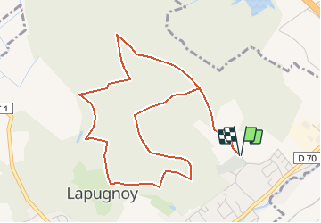
8.2 km | 8.9 km-effort
2h 4min
Yes
Trail Walking Lapugnoy - Le sentier d'Ecques -  Lapugnoy - Photo
Walking
tracegps

Walking

Medium
(3)
Lapugnoy, Hauts-de-France, Pas-de-Calais, France
12.1 km | 14.1 km-effort
3h 0min
Yes
Trail Walking Fouquereuil - Fouquereuil  8.1 km  - Photo
Walking
Blourouce

Walking

Medium
Fouquereuil, Hauts-de-France, Pas-de-Calais, France
7.8 km | 8.9 km-effort
2h 8min
Yes
Trail Mountain bike Annezin - Rando Busnes départ Annezin  - Photo
Mountain bike
tracegps

Mountain bike

Medium
Annezin, Hauts-de-France, Pas-de-Calais, France
45 km | 49 km-effort
3h 0min
Yes
Trail Walking Bruay-la-Buissière - Bois des dames - Photo
Walking
pseudokool

Walking

Medium
Bruay-la-Buissière, Hauts-de-France, Pas-de-Calais, France
13.7 km | 16.3 km-effort
2h 20min
Yes
Trail On foot Gonnehem - Sir J2 - Photo
On foot
l.b62

On foot

Easy
Gonnehem, Hauts-de-France, Pas-de-Calais, France
5.6 km | 5.9 km-effort
1h 20min
Yes
Trail Walking Gonnehem - randonnée Sire J - Photo
Walking
l.b62

Walking

Medium
Gonnehem, Hauts-de-France, Pas-de-Calais, France
10.9 km | 11.5 km-effort
2h 36min
Yes
Trail Walking Lillers - Lillers et le bois de Busnettes - Photo
Walking
BrassensJC

Walking

Easy
Lillers, Hauts-de-France, Pas-de-Calais, France
14.1 km | 14.9 km-effort
4h 0min
Yes
Trail Walking Lapugnoy - SityTrail - Le sentier d'Ecques -  Lapugnoy - Photo
Walking
Blourouce

Walking

Difficult
Lapugnoy, Hauts-de-France, Pas-de-Calais, France
11.9 km | 13.8 km-effort
3h 9min
Yes


Close
My subscriptions