Trail Hunting Fargues-sur-Ourbise - chasse avec Philippe  - Photo
 ptickt
ptickt

User

© OpenStreetMap contributors
Length
Length
5.9 km
Max alt
Max alt
177 m
Uphill gradient
Uphill gradient
72 m
Km-Effort
Km-Effort  
6.8 km
Min alt
Min alt
132 m
Downhill gradient
Downhill gradient
73 m
Boucle
Boucle
Yes
Creation date :
2020-12-27 07:41:46.767
Updated on :
2020-12-27 10:27:20.337

(0 Reviews)

Hunting
Hunting
2h45
Difficulty : Easy

Scan this QR Code to open this trail in the SityTrail application

FREE GPS app for hiking

Logo SityTrail SityTrail

IGN / Geographical institutes

Download SityTrail from the App Store Download SityTrail from Google Play

Logo SityTrail SityTrail World

The world is yours!

Download SityTrail from the App Store Download SityTrail from Google Play Download SityTrail on Huawei AppGallery

About

Trail Hunting of 5.9 km to be discovered at New Aquitaine, Lot-et-Garonne, Fargues-sur-Ourbise. This trail is proposed by ptickt.

Description

chasse à la bécasse

Elevation profile

Positioning

Country:
France
Region :
New Aquitaine
Department/Province :
Lot-et-Garonne
Municipality :
Fargues-sur-Ourbise
Location:
Unknown
Start:(UTM)
276673 ; 4901941 (31T) N.

Trails nearby

Trail On foot Xaintrailles - Xaintrailles, la balade du château - 4.7 km - Photo
On foot
GUIDE+

On foot

Easy
Xaintrailles, New Aquitaine, Lot-et-Garonne, France
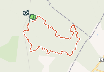
4.6 km | 5.9 km-effort
1h 19min
Yes
Trail On foot Pompiey - De Xaintrailles à Pompiey, lectures de paysage - 10.7 km - Photo
On foot
GUIDE+

On foot

Easy
Pompiey, New Aquitaine, Lot-et-Garonne, France
11.6 km | 14.7 km-effort
3h 20min
Yes
Trail On foot Fargues-sur-Ourbise - Fargues-sur-Ourbise, une île en forêt - 11.7 km - Photo
On foot
GUIDE+

On foot

Easy
Fargues-sur-Ourbise, New Aquitaine, Lot-et-Garonne, France
9.9 km | 11.2 km-effort
2h 32min
No
Trail Walking Pompiey - Randonnée Pompiey-Xaintrailles-lac de Lalague-Pompiey - Photo
Walking
Forsans

Walking

Easy
Pompiey, New Aquitaine, Lot-et-Garonne, France
14.8 km | 18.3 km-effort
4h 36min
Yes
Trail On foot Fargues-sur-Ourbise - Fargues-sur-Ourbise - La forêt domaniale de Campet - 5.5 km - Photo
On foot
GUIDE+

On foot

Easy
Fargues-sur-Ourbise, New Aquitaine, Lot-et-Garonne, France
5.3 km | 6 km-effort
1h 22min
Yes
Trail On foot Caubeyres - Caubeyres, la fontaine bouillonnante - 10.7 km - Photo
On foot
GUIDE+

On foot

Easy
Caubeyres, New Aquitaine, Lot-et-Garonne, France
10.2 km | 12.8 km-effort
2h 54min
Yes
Trail On foot Damazan - Saint-Pierre-de-Buzet, la randonnée du Cap-du-Bosc - 12 km - Photo
On foot
GUIDE+

On foot

Easy
Damazan, New Aquitaine, Lot-et-Garonne, France
14.1 km | 19 km-effort
4h 19min
Yes
Trail On foot Xaintrailles - Ambrus, la balade forestière de Pelane - 7.3 km - Photo
On foot
GUIDE+

On foot

Easy
Xaintrailles, New Aquitaine, Lot-et-Garonne, France
7.1 km | 8.8 km-effort
1h 59min
Yes
Trail On foot Xaintrailles - Ambrus, promenade vers le vignoble de Padère - 9.5 km - Photo
On foot
GUIDE+

On foot

Easy
Xaintrailles, New Aquitaine, Lot-et-Garonne, France
5.1 km | 6.1 km-effort
1h 23min
No


Close
My subscriptions