Trail On foot Gehée - Randonnée - boucle bleue - Géhée - Photo

Randonnée - boucle bleue - Géhée

© OpenStreetMap contributors
Length
Length
5.2 km
Max alt
Max alt
164 m
Uphill gradient
Uphill gradient
75 m
Km-Effort
Km-Effort  
6.2 km
Min alt
Min alt
124 m
Downhill gradient
Downhill gradient
76 m
Boucle
Boucle
Yes
Creation date :
2020-12-26 09:11:31.179
Updated on :
2020-12-26 09:21:06.348

(0 Reviews)

On foot
On foot
1h30
Difficulty : Easy

Scan this QR Code to open this trail in the SityTrail application

FREE GPS app for hiking

Logo SityTrail SityTrail

IGN / Geographical institutes

Download SityTrail from the App Store Download SityTrail from Google Play

Logo SityTrail SityTrail World

The world is yours!

Download SityTrail from the App Store Download SityTrail from Google Play Download SityTrail on Huawei AppGallery

About

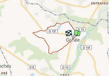
Trail On foot of 5.2 km to be discovered at Centre-Loire Valley, Indre, Gehée. This trail is proposed by Fredrando64.

Description

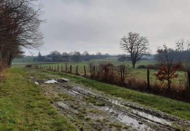
Sentier balisé en bleu au départ de l'église de Géhée.
Totalisant 5km et arpentant de jolis chemins avec des forêts, des champs, des points de vue sur la campagne alentour.
Quelques portions de route mais de faible durée et sur route pas/peu passagère.

Elevation profile

Positioning

Country:
France
Region :
Centre-Loire Valley
Department/Province :
Indre
Municipality :
Gehée
Location:
Unknown
Start:(UTM)
386211 ; 5211513 (31T) N.

Trails nearby

Trail On foot Gehée - Randonnée - boucle jaune - Géhée - Photo
On foot
Fredrando64

On foot

Easy
Gehée, Centre-Loire Valley, Indre, France
10.5 km | 12.1 km-effort
2h 45min
Yes
Trail Horseback riding Langé - boucle marchaisiere / la boutelaie / le marchais/plaineffe - Photo
Horseback riding
Gwen Bonneau

Horseback riding

Easy
Langé, Centre-Loire Valley, Indre, France
7.2 km | 8 km-effort
1h 2min
No


Close
My subscriptions