![](/images/other/stat-length.png)
![Trail Walking Duranus - Cime de Roccassièra depuis l'Engarvin - Photo](https://media.geolcdn.com/t/1900/400/ext.pjpeg?maxdim=2&url=https%3A%2F%2Fservices.sitytrail.com%2FGeolivesWS%2FDownloadMedia.ashx%3FTrailID%3D262036%26Media%3Dfix__20140330144337.jpg)
Cime de Roccassièra depuis l'Engarvin
boboazur
User
![Length](/images/other/stat-length.png)
Length
16.1 km
![Max alt](https://static1.geolcdn.com/siteimages/upload/files/1508320355ic_sort_altitude_max_24dp.png)
Max alt
1483 m
![Uphill gradient](https://static1.geolcdn.com/siteimages/upload/files/1508320355ic_sort_den_pos_24dp.png)
Uphill gradient
894 m
![Km-Effort](/images/other/stat-length.png)
Km-Effort
28 km
![Min alt](https://static1.geolcdn.com/siteimages/upload/files/1508320355ic_sort_altitude_min_24dp.png)
Min alt
703 m
![Downhill gradient](https://static1.geolcdn.com/siteimages/upload/files/1508320355ic_sort_den_neg_24dp.png)
Downhill gradient
893 m
![Boucle](https://static1.geolcdn.com/siteimages/upload/files/16400158638029165_repeat_loop_refresh_sync_direction_icon.png)
Boucle
Yes
Creation date :
2014-12-10 00:00:00.0
Updated on :
2014-12-10 00:00:00.0
![Walking](https://static1.geolcdn.com/sitytour/trail-icons/101.png)
6h59
Difficulty : Medium
![Scan this QR Code to open this trail in the SityTrail application](https://capi.geolives.com/qq0zvz2zws4bq2lad0pu/sitytour/trails/262036/qr.png?size=200)
FREE GPS app for hiking
About
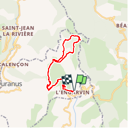
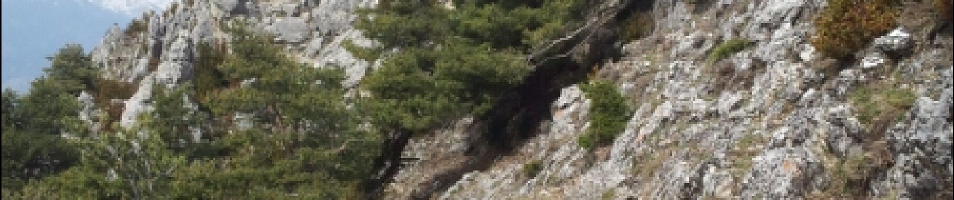
Trail Walking of 16.1 km to be discovered at Provence-Alpes-Côte d'Azur, Maritime Alps, Duranus. This trail is proposed by boboazur.
Description
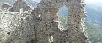
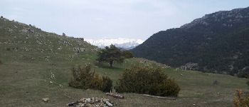
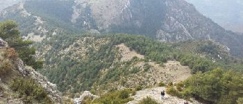
Très belle rando au départ de l'Engarvin, petit hameau apres Coarraze en venant de Nice. Montée en passant par les Ruines de Rocca Sparviera, puis la Cime de Roccassiera d'où l'on jouit d'une vue à 360° mer et cimes du Mercantour.
Positioning
Country:
France
Region :
Provence-Alpes-Côte d'Azur
Department/Province :
Maritime Alps
Municipality :
Duranus
Location:
Unknown
Start:(Dec)
Start:(UTM)
363784 ; 4861069 (32T) N.
Comments
Trails nearby
![Trail Walking Utelle - Le Brec d'Utelle 1604m 19-04-22 - Photo](https://media.geolcdn.com/t/375/260/f3263017-78d2-4ab0-b769-f83aa3feee5d.jpg&format=jpg&maxdim=2)
![Walking Walking](https://static1.geolcdn.com/sitytour/trail-icons/101.png)
Le Brec d'Utelle 1604m 19-04-22
Walking
Medium
Utelle,
Provence-Alpes-Côte d'Azur,
Maritime Alps,
France
![](/images/other/stat-length.png)
11.2 km | 22 km-effort
4h 15min
![](https://static1.geolcdn.com/siteimages/upload/files/16400158638029165_repeat_loop_refresh_sync_direction_icon.png)
Yes
![Trail On foot Lucéram - Circuit du Grand Braus - Photo](https://media.geolcdn.com/t/375/260/4bf0d9dd-6921-4e02-9a25-877c427da130.jpeg&format=jpg&maxdim=2)
![On foot On foot](https://static1.geolcdn.com/sitytour/trail-icons/100.png)
Circuit du Grand Braus
On foot
Easy
Lucéram,
Provence-Alpes-Côte d'Azur,
Maritime Alps,
France
![](/images/other/stat-length.png)
9.9 km | 18.6 km-effort
4h 13min
![](https://static1.geolcdn.com/siteimages/upload/files/16400158638029165_repeat_loop_refresh_sync_direction_icon.png)
Yes
![Trail On foot Coaraze - Rocca Sparvièra - Photo](https://media.geolcdn.com/t/375/260/b70c2ec2-277e-4b66-a927-a7ae11b9ea3a.jpeg&format=jpg&maxdim=2)
![On foot On foot](https://static1.geolcdn.com/sitytour/trail-icons/100.png)
Rocca Sparvièra
On foot
Easy
Coaraze,
Provence-Alpes-Côte d'Azur,
Maritime Alps,
France
![](/images/other/stat-length.png)
10.5 km | 17.6 km-effort
3h 59min
![](https://static1.geolcdn.com/siteimages/upload/files/16400158638029165_repeat_loop_refresh_sync_direction_icon.png)
Yes
![Trail Walking Duranus - Rocca Sparviera Rocca Siera - Photo](https://media.geolcdn.com/t/375/260/cfa7ac61-c812-43a1-a04c-577e01c4a8ee.jpg&format=jpg&maxdim=2)
![Walking Walking](https://static1.geolcdn.com/sitytour/trail-icons/101.png)
Rocca Sparviera Rocca Siera
Walking
Very difficult
Duranus,
Provence-Alpes-Côte d'Azur,
Maritime Alps,
France
![](/images/other/stat-length.png)
16 km | 28 km-effort
6h 18min
![](https://static1.geolcdn.com/siteimages/upload/files/16400158638029165_repeat_loop_refresh_sync_direction_icon.png)
Yes
![Trail Walking Coaraze - Rocca Spavierra - Photo](https://media.geolcdn.com/t/375/260/ext.jpg?maxdim=2&url=https%3A%2F%2Fstatic1.geolcdn.com%2Fsiteimages%2Fupload%2Ffiles%2F1553511878bg_sport_marche.png)
![Walking Walking](https://static1.geolcdn.com/sitytour/trail-icons/101.png)
Rocca Spavierra
Walking
Medium
(1)
Coaraze,
Provence-Alpes-Côte d'Azur,
Maritime Alps,
France
![](/images/other/stat-length.png)
11.6 km | 19.6 km-effort
4h 6min
![](https://static1.geolcdn.com/siteimages/upload/files/16400158638029165_repeat_loop_refresh_sync_direction_icon.png)
Yes
![Trail Walking Utelle - Utelle, Brec d'Utelle - Photo](https://media.geolcdn.com/t/375/260/7d826307-5252-4f94-914a-8eefe923eff9.jpg&format=jpg&maxdim=2)
![Walking Walking](https://static1.geolcdn.com/sitytour/trail-icons/101.png)
Utelle, Brec d'Utelle
Walking
Very difficult
(1)
Utelle,
Provence-Alpes-Côte d'Azur,
Maritime Alps,
France
![](/images/other/stat-length.png)
11.2 km | 22 km-effort
4h 59min
![](https://static1.geolcdn.com/siteimages/upload/files/16400158638029165_repeat_loop_refresh_sync_direction_icon.png)
Yes
![Trail Walking Levens - Crête du Férion 1412m 17-04-22 - Photo](https://media.geolcdn.com/t/375/260/d630ef2c-0149-421b-9b71-c0805c57034c.jpg&format=jpg&maxdim=2)
![Walking Walking](https://static1.geolcdn.com/sitytour/trail-icons/101.png)
Crête du Férion 1412m 17-04-22
Walking
Medium
Levens,
Provence-Alpes-Côte d'Azur,
Maritime Alps,
France
![](/images/other/stat-length.png)
12 km | 22 km-effort
4h 30min
![](https://static1.geolcdn.com/siteimages/upload/files/16400158638029165_repeat_loop_refresh_sync_direction_icon.png)
Yes
![Trail On foot Levens - Crête du Férion - Photo](https://media.geolcdn.com/t/375/260/d2999666-b0d9-4a97-b6d4-103e7aa801ec.jpeg&format=jpg&maxdim=2)
![On foot On foot](https://static1.geolcdn.com/sitytour/trail-icons/100.png)
Crête du Férion
On foot
Medium
Levens,
Provence-Alpes-Côte d'Azur,
Maritime Alps,
France
![](/images/other/stat-length.png)
13 km | 24 km-effort
5h 26min
![](https://static1.geolcdn.com/siteimages/upload/files/16400158638029165_repeat_loop_refresh_sync_direction_icon.png)
Yes
![Trail On foot Utelle - Brec d'Utelle - Photo](https://media.geolcdn.com/t/375/260/fca2a9ca-c206-4e1f-8947-7d439ea79496.jpeg&format=jpg&maxdim=2)
![On foot On foot](https://static1.geolcdn.com/sitytour/trail-icons/100.png)
Brec d'Utelle
On foot
Medium
Utelle,
Provence-Alpes-Côte d'Azur,
Maritime Alps,
France
![](/images/other/stat-length.png)
11.2 km | 22 km-effort
5h 2min
![](https://static1.geolcdn.com/siteimages/upload/files/16400158638029165_repeat_loop_refresh_sync_direction_icon.png)
Yes