Trail Walking Cras - Au dessus vallée du Vers 18 Km - Photo

Au dessus vallée du Vers 18 Km

 fxhedon
fxhedon

User

© OpenStreetMap contributors
Length
Length
39 km
Max alt
Max alt
408 m
Uphill gradient
Uphill gradient
670 m
Km-Effort
Km-Effort  
48 km
Min alt
Min alt
119 m
Downhill gradient
Downhill gradient
711 m
Boucle
Boucle
No
Creation date :
2020-12-12 11:01:20.0
Updated on :
2020-12-13 08:25:53.557

(0 Reviews)

Walking
Walking
4h00
Difficulty : Unknown

Scan this QR Code to open this trail in the SityTrail application

FREE GPS app for hiking

Logo SityTrail SityTrail

IGN / Geographical institutes

Download SityTrail from the App Store Download SityTrail from Google Play

Logo SityTrail SityTrail World

The world is yours!

Download SityTrail from the App Store Download SityTrail from Google Play Download SityTrail on Huawei AppGallery

About

Trail Walking of 39 km to be discovered at Occitania, Lot, Cras. This trail is proposed by fxhedon.

Description

Belle randonnée sur le causse et la vallée du Vers

Elevation profile

Positioning

Country:
France
Region :
Occitania
Department/Province :
Lot
Municipality :
Cras
Location:
Unknown
Start:(UTM)
385342 ; 4932627 (31T) N.

Trails nearby

Trail Walking Les Pechs-du-Vers - Saint Martin - Lauzès2-12656076 - Photo
Walking
houbart

Walking

Very difficult
(1)
Les Pechs-du-Vers, Occitania, Lot, France
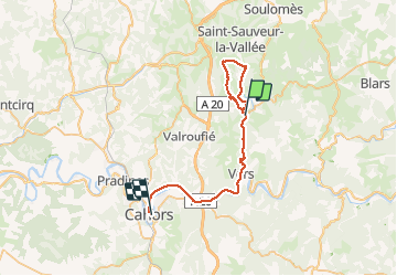
13.6 km | 19 km-effort
4h 19min
Yes
Trail Walking Saint-Géry-Vers - Vers merlan pech picou - Photo
Walking
GUIDE
antignacs

Walking

Very easy
Saint-Géry-Vers, Occitania, Lot, France
10.2 km | 13.5 km-effort
2h 13min
No
Trail Walking Sabadel-Lauzès - Lentillac mas de Pouchou  - Photo
Walking
GUIDE
antignacs

Walking

Very easy
Sabadel-Lauzès, Occitania, Lot, France
12.4 km | 15.8 km-effort
2h 47min
Yes
Trail Walking Cras - boucle mossoronniere oppidum murcens vallée de la rose - Photo
Walking
Glurps

Walking

Difficult
Cras, Occitania, Lot, France
18.4 km | 25 km-effort
6h 25min
Yes
Trail Walking Cabrerets - Merlan c - Photo
Walking
GUIDE
antignacs

Walking

Very easy
Cabrerets, Occitania, Lot, France
12 km | 14.4 km-effort
2h 33min
Yes
Trail Walking Cras - Guillot Gironde Cras Murcens  - Photo
Walking
GUIDE
antignacs

Walking

Easy
Cras, Occitania, Lot, France
14 km | 19.3 km-effort
3h 16min
Yes
Trail Walking Francoulès - Francoules  - Photo
Walking
GUIDE
antignacs

Walking

Very easy
Francoulès, Occitania, Lot, France
9 km | 11.9 km-effort
1h 57min
Yes
Trail Walking Cras - guillotine bout de la côté - Photo
Walking
GUIDE
antignacs

Walking

Very easy
Cras, Occitania, Lot, France
7.1 km | 9.5 km-effort
1h 45min
Yes
Trail Mountain bike Cras - 2022-07-04_13h02m11_La Boucle du Vers en Géocaching - Photo
Mountain bike
sebcar

Mountain bike

Difficult
Cras, Occitania, Lot, France
30 km | 38 km-effort
2h 36min
Yes


Close
My subscriptions