Trail Walking Val de Bagnes - YHH040 Verbier - Saas-Fee (1er jour) - Photo

YHH040 Verbier - Saas-Fee (1er jour)

© OpenStreetMap contributors
Length
Length
3.4 km
Max alt
Max alt
2436 m
Uphill gradient
Uphill gradient
245 m
Km-Effort
Km-Effort  
5.9 km
Min alt
Min alt
2185 m
Downhill gradient
Downhill gradient
8 m
Boucle
Boucle
No
Creation date :
2015-04-15 00:00:00.0
Updated on :
2015-04-15 00:00:00.0

(0 Reviews)

Walking
Walking
1h00
Difficulty : Easy

Scan this QR Code to open this trail in the SityTrail application

FREE GPS app for hiking

Logo SityTrail SityTrail

IGN / Geographical institutes

Download SityTrail from the App Store Download SityTrail from Google Play

Logo SityTrail SityTrail World

The world is yours!

Download SityTrail from the App Store Download SityTrail from Google Play Download SityTrail on Huawei AppGallery

About

Trail Walking of 3.4 km to be discovered at Valais/Wallis, Entremont, Val de Bagnes. This trail is proposed by yveshumbert.

Description

On commence la marche à l’arrivée des télécabines des Ruinettes.
Pour se rendre à la cabane Mt-Fort, on suit le bisse pendant un bon moment avant d’entreprendre une courte montée pour arriver à la cabane

Elevation profile

Points of interest

Point of interest Val de Bagnes - Télécabine des Ruinettes - Photo
yveshumbert
Point of interest Val de Bagnes - Cabane du Mt Fort - Photo
yveshumbert
VAL DE BAGNES 

Positioning

Country:
Switzerland
Region :
Valais/Wallis
Department/Province :
Entremont
Municipality :
Val de Bagnes
Location:
Unknown
Start:(UTM)
364946 ; 5105647 (32T) N.

Trails nearby

Trail Walking Nendaz - lac Cleuson - cabane St Laurent - Photo
Walking
dalla.anthony

Walking

Medium
(2)
Nendaz, Valais/Wallis, Conthey, Switzerland
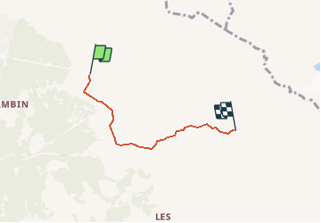
19.3 km | 32 km-effort
6h 37min
Yes
Trail On foot Val de Bagnes - Ancien Bisse du Levron - Photo
On foot
GUIDE+

On foot

Easy
Val de Bagnes, Valais/Wallis, Entremont, Switzerland
10.7 km | 13.4 km-effort
3h 2min
No
Trail On foot Val de Bagnes - Col Termin-Louvie - Photo
On foot
GUIDE+

On foot

Easy
Val de Bagnes, Valais/Wallis, Entremont, Switzerland
3.8 km | 6.3 km-effort
1h 25min
No
Trail Walking Val de Bagnes - La Haute Route : J2 - Photo
Walking
Greg813

Walking

Difficult
Val de Bagnes, Valais/Wallis, Entremont, Switzerland
12.4 km | 21 km-effort
3h 37min
No
Trail On foot Val de Bagnes - Promenade de la Dranse - Photo
On foot
GUIDE+

On foot

Easy
Val de Bagnes, Valais/Wallis, Entremont, Switzerland
7.1 km | 9.4 km-effort
2h 8min
No
Trail On foot Val de Bagnes - Bruson - Moay - Photo
On foot
GUIDE+

On foot

Easy
Val de Bagnes, Valais/Wallis, Entremont, Switzerland
3.6 km | 10 km-effort
2h 16min
No
Trail Walking Val de Bagnes - CHX ZRMT Étape 4 de Cabane de Louvie à Cabane de Prafleuri - Photo
Walking
jeff2

Walking

Medium
Val de Bagnes, Valais/Wallis, Entremont, Switzerland
12.3 km | 25 km-effort
5h 28min
No
Trail Walking Riddes - Croix de Coeur - Pierre Avoi - Photo
Walking
jptritten

Walking

Medium
(2)
Riddes, Valais/Wallis, Martigny, Switzerland
6.4 km | 10.9 km-effort
2h 26min
Yes
Trail sport Nendaz - 20240911 Siviez dent de Nendaz - Photo
sport
ThonyM

sport

Very easy
Nendaz, Valais/Wallis, Conthey, Switzerland
15.2 km | 28 km-effort
Unknown
Yes


Close
My subscriptions